Logo 468x120

2023 Tropical Weather

Messages
535
Reaction score
474
Location
Northern Europe
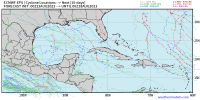
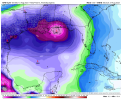
Interestingly, both Dora and the current waves in the Atlantic face similarly dry, low-shear environments, along with brisk easterlies, yet the former is thriving while the latter are struggling. Visible and water-vapour imagery reveal extensive stratocumulus beside Dora and the Atlantic waves, indicating stable air, yet for some reason only only Dora is thriving. I must be honest: I am more than a little surprised.

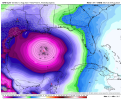
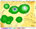
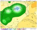
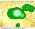
Re: future TC genesis in the Atlantic: the EPS, GEFS, and the Canadian (GEM) model seem to indicate that the earliest potential development is on 15 August, in association with a wave that bypasses the Cabo Verde islands. This wave would likely take about six days to traverse the Atlantic. By 20 August, as mentioned previously, the EPS indicates a threatening steering current.

My personal hypothesis: if this season is to feature potential threats to the CONUS, it must show signs of activity in the MDR by mid-August, at the latest. So this upcoming wave will be very significant. If it develops, it could pose a potentially significant threat to the CONUS, based on climatology. If not, it will serve as a bellwether, highlighting a hostile background-state.

If it does not develop, then the rest of the season will likely struggle to overcome +ENSO, the warm subtropics, and a shift toward a seaward steering current.
 
Messages
535
Reaction score
474
Location
Northern Europe
2023-Dora-CPAC-1.jpg


Dora is the Pacific’s version of Irma (2017) and is beginning to resemble other long-lived Category-5 Pacific cyclones such as Typhoons Rita (1978) and Ioke (2006). The system looks as impressive as it did three days ago, yet looks to maintain or increase its intensity for the foreseeable future. Of course, Dora is far from the first Pacific hurricane to maintain Category-4+ status for an extended period of time: Fico (1978) and John (1994) similarly did so, along with other examples. Nevertheless, by all measures Dora is an extremely impressive system, and fortunately is the best kind of cyclone: an intense, seagoing long-tracker. As I mentioned previously, moreover, in common with similar systems, Dora has likely being underestimated, in large part owing to its compact size, and has likely maintained Category-5—or, at the very least, high-end Category-4—status for three consecutive days, given its largely-unchanged presentation on satellite imagery. Even periodic ERCs seem to have exerted very little influence on its real-time intensity, nor have copious amounts of low-to-mid-level dry air. In all respects Dora is outstanding.
 
Messages
535
Reaction score
474
Location
Northern Europe
This is why I'm concerned.
While the steering and climatology would normally be disconcerting, the global ensembles are actually bearish on development. During the same timeframe (15–20 August) the models show a train of hurricanes in the E/CPAC, while lacking a similarly concentrated area in the Atlantic. We could see two or even three hurricanes in the Pacific yet not even a TS in the Atlantic through late August. Also, as mentioned, steering currents usually persist for only a week or so. At this stage a significant upturn in TC activity over the MDR seems unlikely prior to the first week of September. In the meantime guidance such as the EPS shows a landfall-friendly pattern within a week or so of 20 August. If no system were present during this timeframe, then a week’s delay would increase the likelihood of a shift in the pattern, resulting in less of a risk to the CONUS. Later on El Niño will become more of a factor as well. So I remain skeptical about the prospects of TC development and significant landfalls, but we shall see.
 
Last edited:

Taylor Campbell

Moderator
Moderator
PerryW Project Supporter
Messages
2,138
Reaction score
2,242
Location
Wedowee, AL
Special Affiliations
  1. SKYWARN® Volunteer
This is why I'm concerned.

The watching starts now in the east Atlantic. Multiple global models have jumped on board with development. I'm on the lookout for a disturbance near the Leeward Islands by next Friday, the 18th.
 

Taylor Campbell

Moderator
Moderator
PerryW Project Supporter
Messages
2,138
Reaction score
2,242
Location
Wedowee, AL
Special Affiliations
  1. SKYWARN® Volunteer
Satellite shows a significantly disturbed balance of low level convergence and upper level divergence at 10N/20W.
 

JPWX

Member
Messages
1,583
Reaction score
4,302
Location
Smithville MS
I would expect NHC to start monitoring a wave or something by next weekend at the very least. Everything is lining for the next 5 weeks to be a conga line so to speak of tropical systems.
 

JPWX

Member
Messages
1,583
Reaction score
4,302
Location
Smithville MS
The fact we have both the GFS Operational, the GFS Ensemble, and the Euro Ensemble hinting at a strong hurricane in the Gulf late month (roughly around August 27th) really says a lot. Plus given that the Gulf has a history of 24 major hurricanes between August 15th to 31st going back to 1851 also gives precedence. We shall see, but seems at least a strong tropical system is on the table in the Gulf going forward.
 

Attachments

  • eps_cyclones_gulf_360 (2).png
    eps_cyclones_gulf_360 (2).png
    142.8 KB · Views: 0
  • gefs_cyclones_gulf_360 (2).png
    gefs_cyclones_gulf_360 (2).png
    202.8 KB · Views: 0
  • gefs_cyclones_gulf_360 (1).png
    gefs_cyclones_gulf_360 (1).png
    223.1 KB · Views: 0
  • gfs-deterministic-gulf-mslp_norm_anom-3267200.png
    gfs-deterministic-gulf-mslp_norm_anom-3267200.png
    127.6 KB · Views: 0
  • gfs-deterministic-gulf-mslp_norm_anom-3094400.png
    gfs-deterministic-gulf-mslp_norm_anom-3094400.png
    122.6 KB · Views: 0
  • ecmwf-ensemble-avg-gulf-mslp_ens_min-3051200 (1).png
    ecmwf-ensemble-avg-gulf-mslp_ens_min-3051200 (1).png
    125.3 KB · Views: 0
  • gfs-ensemble-all-avg-gulf-mslp_ens_min-3288800.png
    gfs-ensemble-all-avg-gulf-mslp_ens_min-3288800.png
    112.7 KB · Views: 0
  • gfs-ensemble-all-avg-gulf-mslp_ens_min-3245600.png
    gfs-ensemble-all-avg-gulf-mslp_ens_min-3245600.png
    112.9 KB · Views: 0

Taylor Campbell

Moderator
Moderator
PerryW Project Supporter
Messages
2,138
Reaction score
2,242
Location
Wedowee, AL
Special Affiliations
  1. SKYWARN® Volunteer
Satellite shows a significantly disturbed balance of low level convergence and upper level divergence at 10N/20W.
This initial assessment area remains concentrated and has shifted south and west to near 10N/28W.
 

JPWX

Member
Messages
1,583
Reaction score
4,302
Location
Smithville MS
Hurricane Dora in the Pacific, I thought there was a Hurricane Dora that hit the Florida east cost in the 1960s and was bad enough to be retired. Am I remembering wrong?
Nope. Dora hit in 1964 as a category 4 on North Florida from the Atlantic side. It was retired and replaced with Donna which was then retired and replaced with Dolly.
 
Back
Top