Austin Dawg
Member
I'd really like to know who thought it was a good idea to go ahead with the Padres games in San Diego and the Post Malone concert at Glen Helen...
")
Follow along with the video below to see how to install our site as a web app on your home screen.
Note: This feature may not be available in some browsers.
I'd really like to know who thought it was a good idea to go ahead with the Padres games in San Diego and the Post Malone concert at Glen Helen...

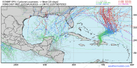
We're lucky the GOM system won't be staying out over water for very long.The Atlantic is BUSY! We have Tropical Storm Emily, Frank, and Gert out there now.
Invest 91L in the Gulf of Mexico has a likely probability of becoming a named storm before hitting southern Texas tomorrow morning.
Invest 92L in the Eastern Atlantic has a likely probability of becoming a named system.
Yeah. I don't expect there to be much if any significant noticeable change in water temperatures after this moves through. If it were a slow mover, that would be a different story.We're lucky the GOM system won't be staying out over water for very long.

More from the same source:“They seem to be naming storms a lot more than they used to,” said Frank, who directed the hurricane center from 1974 to 1987 and is now chief meteorologist for KHOU-TV. “This year (2007—ed.), I would put at least four storms in a very questionable category, and maybe even six.” … their central pressure — another measure of intensity — suggested they actually remained depressions or were non-tropical systems. … Insurance companies use…trends to set homeowners’ rates. … Before satellites, scientists had few ways to tell the difference between tropical systems and non-tropical storms. As a result, some non-tropical storms probably were named.
Simply look at storms like Harold and other “shorties” and compare with previous tropical storms from the 1980s and early ‘90s. These systems are basically glorified tropical waves whose gale-force winds are related to transient convection and most likely do not reflect sustained, one-minute values at standard elevation over water, much less land. Unfortunately, our rather scanty records are becoming even less reliable due to changes in standards for classification since the late ‘90s. Given that HURDAT is used to assign insurance-premiums, artificial changes should be quite alarming.He states that the first six tropical storms this year would not have been counted in his time. Nowadays the NHC rushes to name a storm, simply based on wind speeds. His team would have waited until the central pressure dropped to confirm that it really was a tropical storm and not just a thunderstorm. This often explains why named storms are often so short-lasting now.

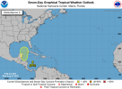
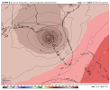
3. Northwestern Caribbean Sea:
A broad area of low pressure, originating along the East Pacific
coast of Central America, is forecast to move into northwestern
Caribbean Sea by this weekend. Some gradual development of this
system is possible thereafter into early next week, and a tropical
depression could form while it moves slowly northward, entering the
eastern Gulf of Mexico.
* Formation chance through 48 hours...low...10 percent.
* Formation chance through 7 days...medium...50 percent.