
Navigation
Install the app
How to install the app on iOS
Follow along with the video below to see how to install our site as a web app on your home screen.
Note: This feature may not be available in some browsers.
More options
-
Welcome to TalkWeather! We see you lurking around TalkWeather! Take the extra step and join us today to view attachments, see less ads and maybe even join the discussion. CLICK TO JOIN TALKWEATHER
You are using an out of date browser. It may not display this or other websites correctly.
You should upgrade or use an alternative browser.
You should upgrade or use an alternative browser.
2023 Tropical Weather
- Thread starter JBishopwx
- Start date

akt1985
Member
Will we have any Hurricane Barbie memes now that Tropical Storm Margot was just named?
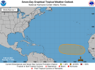
This is pretty, but the two centers are still rather distant. Does this proximity have anything to do with the challenges of forecasting Margot's future or is that from something else?
...forecasts from those models indicate that their deterministic model solutions are part of a wide spectrum of possible tracks for Margot. The ECMWF track ensemble, for instance, has approximately 27 degrees of latitude spread between members at 120 h. We don't have a clear reason to favor any one solution at this time, so the NHC forecast is near the multi-model consensus. It is possible that large track adjustments will be needed to future NHC forecasts.
akt1985
Member
Anyone seeing another system behind Lee threatening New England? I’m going to Boston in a couple of weeks and hate to have to cancel due to Lee or whatever might come behind it.
- Moderator
- #226
Anyone seeing another system behind Lee threatening New England? I’m going to Boston in a couple of weeks and hate to have to cancel due to Lee or whatever might come behind it.
There is a system behind Lee (Invest 97L) that models forecast to become a strong to major hurricane, but with a lot of indications that it’ll remain out to sea.
- Thread starter
- #227
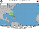
Okay, the current discussion helps. It doesn't sound like Lee has any direct effect.This is pretty, but the two centers are still rather distant. Does this proximity have anything to do with the challenges of forecasting Margot's future or is that from something else?
A general northward motion should continue over the next day or so before the track forecast becomes very challenging. Margot will then become caught in weak steering currents, with the global models showing a blocking ridge developing to the north of the cyclone by late week into the weekend. There remain notable differences between the GFS and ECMWF with regards to the strength and position of this ridge, which has large implications in the longer-range track of Margot, but there has been some tightening of the model consensus since this morning. This supports the storm making a gradual clockwise loop between 36-72 hrs as the ridge initially builds north of the cyclone and then slides off to the east. By 120 hrs, the storm will likely begin accelerating off to the northeast as it gets picked up by the westerlies, but the overall track forecast confidence remains low given the model spread late in the forecast period....
- Moderator
- #229
So with the major pattern shift coming up with a western central US trough and the ridge heights centered off the eastern seaboard we should look for an increase likelihood for a tropical landfall should something develop.
With Lee and Margot dissipated, we have only Tropical Storm Nigel Thornberry left (for those of you who watched The Wild Thornberrys way back when) out in the Atlantic. The next system should develop from this here. Otherwise, going forward, we'll have to watch near the Bahamas/Southeast Coast for in close development then into the Western Caribbean/Gulf of Mexico in October.
Attachments
Advisories coming for system off the East Coast.
Well that escalated quickly
Well that escalated quickly

Literally looked at the NAM and was like what??


- Thread starter
- #237

TornadoFan
Member
Sustained winds up to 70 MPH and pressure down to 986.

