
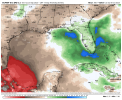
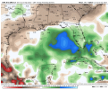
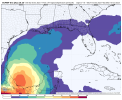
First two weeks of October. Gotta watch the Gulf.
Navigation
Install the app
How to install the app on iOS
Follow along with the video below to see how to install our site as a web app on your home screen.
Note: This feature may not be available in some browsers.
More options
-
Welcome to TalkWeather! We see you lurking around TalkWeather! Take the extra step and join us today to view attachments, see less ads and maybe even join the discussion. CLICK TO JOIN TALKWEATHER
You are using an out of date browser. It may not display this or other websites correctly.
You should upgrade or use an alternative browser.
You should upgrade or use an alternative browser.
2023 Tropical Weather
- Thread starter JBishopwx
- Start date
I hope the weather system that formed near Cape Verde, if it develops (as it probably will), follows Philippe's precedent and just fishes.

- Moderator
- #244
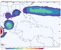
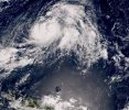
Philippe expected to become a Cat 1 as it floats out over the Atlantic.
View attachment 21734
Ha ha oh my. This storm and its erratic behavior.
Piling up ACE points. I already have my thoughts on next season. LOL!
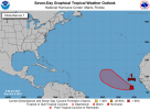
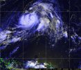
40% chance of development thru next 48 hours and 80% chance of development thru next 7 days. It would be the first MDR tropical system to form this late since Tropical Storm Nadine in 2018.
Attachments
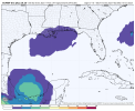
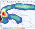
Meanwhile, closer to home, we still have the Gulf to watch. It'll be either a continuation of one of the East Pacific systems or the combination of a tropical wave plus remnants of both East Pacific systems.
Attachments
- Thread starter
- #249
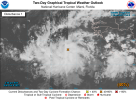
Nothing significant isexpected, but we do have a lemon in the Gulf.
 .
.
.warneagle
Member
Definitely made my trip to Montreal this past weekend less fun, if nothing else. Getting a WEA from Environment Canada was novel, at least.Ha ha oh my. This storm and its erratic behavior.
2023 is only the 2nd time since 1950 where all three Northern Hemisphere basins (Atlantic, Eastern Pacific, and Western Pacific) have all feature one or more tropical systems reaching Category 5 status. The first occurrence was 2018.
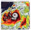
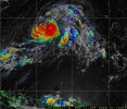
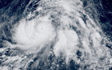
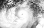
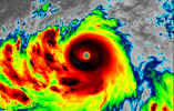
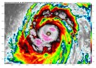
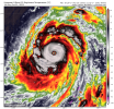
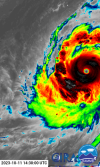
Meanwhile in the Western Pacific, Super Typhoon Bolaven. Saw a 80mph wind increase in 24 hours and a 95mph wind increase in 48 hours.
Attachments
-
 himawari9_15W_band13_202310110045.png464.7 KB · Views: 0
 -
 8fb33e99-520b-4c01-a0a2-4f6dfb632424.jpg391.4 KB · Views: 0
 -
 pi1_snd_0100.jpg187.1 KB · Views: 0
 -
 pi1_trm_0100.jpg114.5 KB · Views: 0
 -
 pi1_vir_0100.jpg175.5 KB · Views: 0
 -
 Screenshot 2023-10-10 201947.png1.8 MB · Views: 0
 -
 Screenshot 2023-10-10 201635.png1.7 MB · Views: 0
 -
 Screenshot 2023-10-10 201705.png2.2 MB · Views: 0
 -
 Screenshot 2023-10-10 201840.png251.7 KB · Views: 0
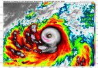
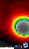
180mph gusts to 200mph 904mb Super Typhoon Bolaven.
Attachments
-
 Screenshot_20231011-095520_Samsung Internet.jpg290.7 KB · Views: 0
 -
 himawari9_15W_band13_202310111435.png494.1 KB · Views: 0
 -
 cira-rammb-slider---himawari---full_disk---band_13-opacity-100---20231011143000.png333.2 KB · Views: 0
 -
 cira-rammb-slider---himawari---full_disk---band_13-opacity-100---20231011143000-1.png122 KB · Views: 0
MattW
Member
- Messages
- 388
- Reaction score
- 382
- Location
- Decatur, GA
- HAM Callsign
- KG4GUF
- Special Affiliations
- SKYWARN® Volunteer
What's your source for these images? They're great!Meanwhile, closer to home, we still have the Gulf to watch. It'll be either a continuation of one of the East Pacific systems or the combination of a tropical wave plus remnants of both East Pacific systems.
WeatherbellWhat's your source for these images? They're great!
MattW
Member
- Messages
- 388
- Reaction score
- 382
- Location
- Decatur, GA
- HAM Callsign
- KG4GUF
- Special Affiliations
- SKYWARN® Volunteer
Thank you!Weatherbell
You're welcome!Thank you!
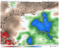
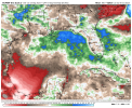
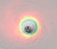
A little more imagery:

