• Welcome to TalkWeather!
    We see you lurking around TalkWeather! Take the extra step and join us today to view attachments, see less ads and maybe even join the discussion.
    CLICK TO JOIN TALKWEATHER

2022 Tropical Weather

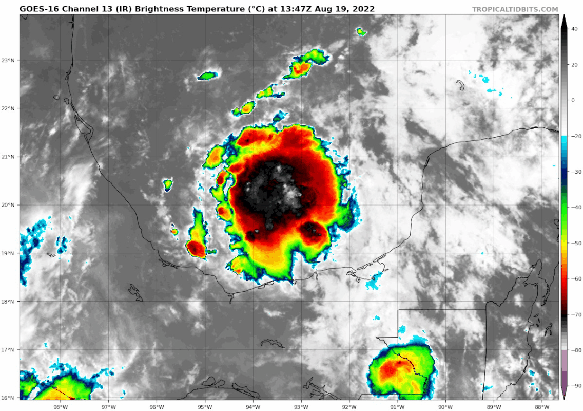
GFS also trying to show some north gulf development by the end of the week.
 
What made this suddenly take off -- warmer water near shore? Change in wind fields?


Glad it was so close to shore when that happened. I wonder if we will see that in the next few storms to form -- I know; there are so many variables...

Edit: Got back on Twitter and saw this -- WOW!

 
Last edited:
• The MJO remains not well defined which is reflected in both the velocity potential anomaly index and RMM observations during the past week.
There is better agreement in the dynamical models depicting continued eastward propagation of the signal across the western Pacific and into the western Hemisphere, but several RMM forecasts generally maintain a low amplitude during the next two weeks.
• The rapid phase speed in RMM space is suggestive of a convectively coupled Kelvin wave over the Pacific projecting onto the index.
Some model solutions (BOM, CFS) hint at a more coherent signal possibly emerging over Africa and the western Indian Ocean, which could be tied to Kelvin wave activity aiding in the reorganization of the MJO in the eastern Hemisphere later in August.
• Other modes of tropical variability are more likely to be primary contributors to precipitation and tropical cyclogenesis in the Pacific and Atlantic during the outlook period.

Source: https://www.cpc.ncep.noaa.gov/products/precip/CWlink/MJO/mjoupdate.pdf
 
Invest 99L is looking great this morning.
goes16-ir-99-L-202208191347.gif
 
The convectively agitated area over Colombia and Venezuela of northern South America has support for further organization as it moves into the Caribbean sea. The operational GFS has been consistent of a tropical system forming out of this activity and getting into the Gulf of Mexico and making landfall in 9 days. The 00z CMC also showed development.

The action in the eastern Atlantic and coming off Africa is the second area to watch. The GFS, CFS have been originating a storm from this area frequently and the EURO showed a storm in last night’s model run.
 
Last edited:
The 12z CMC and GFS model runs continued support for development in the Caribbean Sea. The EURO, GFS, and CMC develop the storm in the eastern Atlantic. The weather charts show less shear and less dry air surrounding these areas so that they actually have a good chance to take off.
 
Invest 90L has been classified in the eastern Atlantic. Last night’s EURO run has it north of the Dominican Republic in 8 days and strengthening. The operational GFS and its ensembles have supported the scenario as well.
 
Last edited:
The HMON and HWRF runs on Invest 90L showed better short term organization for the tropical activity along the ITCZ from 60W to 40W so lets keep an eye on that area.

goes16-ir-catl.gif


Also check out the intense disturbance over Africa. That's about as strong as they come across the continent.

goes16-ir-eatl.gif
 
It's definitely been consistent for a few runs now showing some Caribbean development followed by a track over Cuba then into the north gulf. As far out as it is though, the entire coast is in play, way too early to look at landfall locations.
 
I’m anxious to see what the HRWF and HMON models think of it, but it isn’t listed an invest and they haven’t been run on 90L since yesterday morning. The operational CMC and EURO do nothing with it and have been consistent with that as much as the GFS has made something out of it. However, I did see an EURO ensemble map that showed some members intensifying the system later in the period into a significant system. Indications that the environment may become “very” favorable when it comes closer to the homeland.
 
Good morning Atlantic, I see you remain active with persistent area of thunderstorms. More time and favorable conditions are ahead for you to become something more.
 
Back
Top