• Welcome to TalkWeather!
    We see you lurking around TalkWeather! Take the extra step and join us today to view attachments, see less ads and maybe even join the discussion.
    CLICK TO JOIN TALKWEATHER
  • April 2024 Weather Video of the Month
    Post your nominations now!
Logo 468x120

Hurricane Hurricane Dorian

Taylor Campbell

Moderator
Moderator
PerryW Project Supporter
Messages
2,137
Reaction score
2,241
Location
Wedowee, AL
Special Affiliations
  1. SKYWARN® Volunteer
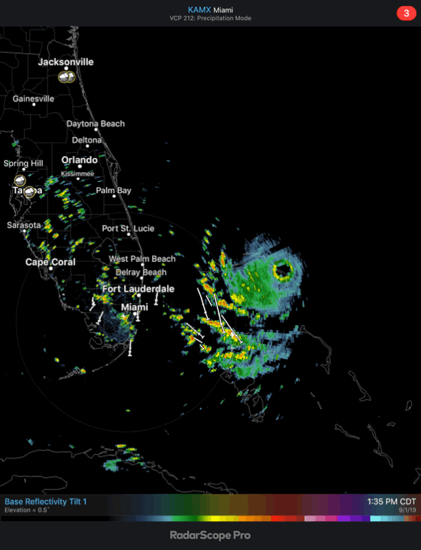
RAP is very close to Florida's coast late tomorrow morning. Calculations show it to be about 80 miles east of West Palm Beach. It then moves 20 miles closer by 2am Tuesday morning.
 
Last edited:

Bama Ravens

Member
Messages
1,210
Reaction score
656
Location
Morris, AL (Northern Jefferson County)
NHC said in their last update that there could be gusts to 220mph.

Also, it’s showing up on base reflectivity from the Miami radar

827337-AA-1929-4-CE7-8-C90-089-C08-A85-CEC.gif
 

MikeP

Member
Messages
211
Reaction score
99
Location
Crestwood South, Bham
SST's look very warm ahead. Looks like gulf stream temps are about 85 degrees-ish. God the outflow now is amazing with all quadrants looking textbook.
 

bjdeming

Member
Sustaining Member
Messages
1,609
Reaction score
1,322
Location
Corvallis, Oregon
Extremely strong wording from the NHC.
View attachment 2010

Aaand people are venturing out to look around while the eye passes. This video is amazing -- the structural damage to the building is intense, but then you look outside and the trees have been stripped of all leaves and their smaller branches. How is this roof and those walls still holding?

At least some nearby buildings, while heavily damaged, are still standing, too.. I expected total devastation; it's a testimony to what the PM was saying this morning about construction codes there.

Apparently there is power somewhere, too, since this made it to the Net.

Nonetheless, they've got another eyewall coming in and should be hunkering down now.
 

Kory

Member
Messages
4,928
Reaction score
2,119
Location
Tuscaloosa, Alabama
Aaand people are venturing out to look around while the eye passes. This video is amazing -- the structural damage to the building is intense, but then you look outside and the trees have been stripped of all leaves and their smaller branches. How is this roof and those walls still holding?

At least some nearby buildings, while heavily damaged, are still standing, too.. I expected total devastation; it's a testimony to what the PM was saying this morning about construction codes there.

Apparently there is power somewhere, too, since this made it to the Net.

Nonetheless, they've got another eyewall coming in and should be hunkering down now.
Probably will see complete destruction of what is left of the infrastructure with the next eyewall coming in.
 

Equus

Member
Messages
3,322
Reaction score
3,473
Location
Jasper, AL
Special Affiliations
  1. SKYWARN® Volunteer
Absolutely Irma-level tree damage from just one side of the eyewall; no doubt the modern analog to the Labor Day hurricane's impact on tropical islands
 

Equus

Member
Messages
3,322
Reaction score
3,473
Location
Jasper, AL
Special Affiliations
  1. SKYWARN® Volunteer
Yeah I'm baffled as to why Michael was immediately forgotten. First landfalling US category five since 1992 (albeit after the fact) with mind-numbing devastation as far as the eye could see and the media moved on within a couple weeks. Still people living in tents and empty foundations everywhere.
 

Equus

Member
Messages
3,322
Reaction score
3,473
Location
Jasper, AL
Special Affiliations
  1. SKYWARN® Volunteer
Will unquestionably be the costliest and most devastating hurricane on modern record there. That it's about 35-40mph stronger than Joaquin is scary. 15mph stronger than Andrew at its landfall too... and stalling with nothing but internal dynamics and possibly slow upwelling to temper it.
 

Kory

Member
Messages
4,928
Reaction score
2,119
Location
Tuscaloosa, Alabama
Will unquestionably be the costliest and most devastating hurricane on modern record there. That it's about 35-40mph stronger than Joaquin is scary. 15mph stronger than Andrew at its landfall too... and stalling with nothing but internal dynamics and possibly slow upwelling to temper it.
I would imagine upwelling would be minimal given the proximity to the Gulf Stream.
 

Equus

Member
Messages
3,322
Reaction score
3,473
Location
Jasper, AL
Special Affiliations
  1. SKYWARN® Volunteer
True... plus it won't be stalling long enough to cause too many issues anyway. Scary to think water temps are only increasing along its path.
 
Back
Top