- Moderator
- #241
Wow! Tomorrow, and Sunday are looking horrific!
Follow along with the video below to see how to install our site as a web app on your home screen.
Note: This feature may not be available in some browsers.
How far east? Grew up in Bee Cave/Westlake


That seems to be a trend as actual sbcape is better modeled, but the current rain will have to move out soon to be reality.Fairly concerning look off the 12z HRRR. This would be around 3am tomorrow.
2am forecast sounding near Tuscaloosa from the 12z HRRR
That's my thinking, its just more widespread than i expectedWe have 70+ dews along the coast with an EML sliding in. This rain should have no bearing on the warm front moving north.
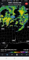
It wasnt expected to be this widespreadWas the ongoing convection this morning expected?
It appears to be weakening a little over the last hour. There was a large mass of rain with some pretty decent dbz on radar south of Birmingham earlier and it seemed to fall apart as it moved north. With that said I was not expecting that much rain on radar this morning.Unless something changes soon, this will kill the expected instability later. It keeps backbuilding and is not lifting north yet.
I am in no means declaring it is over, just saying watch for trends, there will be some changes.It’s still 12-18 hours from the event in Alabama. I think declaring the severe weather threat over is a bit extreme.
All indications are well have rapid moisture recover considering this is not an organized cold pool MCS.