TornadoFan
Member
Yikes, I hope this doesn't verify.
Follow along with the video below to see how to install our site as a web app on your home screen.
Note: This feature may not be available in some browsers.


Basically all of the CAMS are rushing the line of storms/cells into Alabama around midnight, a little after...some show more storms than others...but idea I have is that the evening CAPE will not diminish as much as shown, values could still be nearly 1000j/kj, possibly 1200. Storm mode will be somewhere around supercell/QLCS or becoming linear with time.
that disco was from this morning, they just repeated it this afternoon.BMX Discussion
.LONG TERM...
Saturday through Sunday.
Saturday begins with the previously stalled frontal boundary already
to our north. There is some isentropic lift in the morning on the
south side of that boundary, which could lead to scattered showers
across our northern and northwestern counties, but this should also
lift north of our area by the afternoon/evening hours. Meanwhile, a
surface low pressure system lifts northeastward out of Southeastern
TX and into the Ozarks by Saturday evening, stretching a cold front
through the ArkLaMiss. Guidance suggests a pre-frontal shortwave
could lift through as well, being a trigger for convective
initiation. The upper level trough becomes more negatively tilted
Saturday night, and the low level jet ramps up substantially across
Central AL during the overnight hours. I expect a broken line of
storms to move through MS and into western portions of AL after
midnight Saturday night into Sunday. Ahead of this line, the
environment is highly sheared with 0-6km bulk shear over 50kts and 0-
3km SRH over 350 m2/s2. The mode of storms is still somewhat in
question with some latest guidance suggesting more of a cluster of
convection along the line versus cellular, but 0-6km shear vectors
are forecast to be 40-50 degrees in relation to the north-south
oriented boundary, so I would expect more of a broken line with
individual cells. This is picked up well in the 00z NAM and ECMWF
being consistent with streaks in the precipitation fields. A couple
more potential limiting factors are instability and lapse rates.
Model guidance has gone back and forth on just how much instability
persists given the overnight timing of the storms. Considering the
strong jets at 925mb and 850mb, I think we should be able to
maintain some instability even with the loss of daytime heating due
to the increase in low level moisture and warm air advection from
the Gulf. With the tall, skinny CAPE profiles, it doesn`t take much
change in either the temp or dewpoint to make significant
differences in the overall instability, which helps explain the back
and forth nature in the model guidance. The lapse rates aren`t
overly impressive, but the strong dynamic forcing should help
overcome this. Therefore, I`ve increased the overall risk of severe
weather across Central AL and kept the timing mainly in the early
morning hours Sunday to early afternoon. Some newer guidance tries
to bring in a second line of rain behind the main line, but
environmental variables do not look sufficient in the late afternoon
to Sunday evening to support any severe storms.
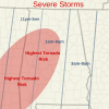
You feel like there’s an appreciable tornadic risk spreading into central AL?Here are my thoughts for Alabama.
Here are my thoughts for Alabama.


A potential for long-track tornadoes will be possible and a regional outbreak of tornadoes could occur across parts of the moderate risk area. By early evening, the cluster of severe storms is forecast to move into southwestern and central Mississippi where a potential for strong tornadoes will continue. However, the wind-damage threat may become the more dominant hazard as the convection moves further to the east where instability is forecast to be weaker.
So a midnight and after tornadoes could happen? I hate night storms.Basically all of the CAMS are rushing the line of storms/cells into Alabama around midnight, a little after...some show more storms than others...but idea I have is that the evening CAPE will not diminish as much as shown, values could still be nearly 1000j/kj, possibly 1200. Storm mode will be somewhere around supercell/QLCS or becoming linear with time.
How far east? Grew up in Bee Cave/WestlakeYou're not making me feel any better. I'm going to head on to bed so I can get up and start monitoring this early. I have a feeling I am at the begining of the firing line here on the east side of I-35.
That would be bad enough at any time of the day, but at 6:00 in the morning? Bad news. I agree, hopefully that doesn't verify.Yikes, I hope this doesn't verify.