cincywx
Member
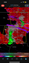
New tornado watch for the S IN / SW OH / NW KY region.
There are a few cells attempting to get going ahead of the main line but they are struggling to produce anything other than hail at this point.

THE NWS STORM PREDICTION CENTER HAS ISSUED A
* TORNADO WATCH FOR PORTIONS OF
FAR SOUTHEAST INDIANA
NORTHERN KENTUCKY
FAR SOUTHWEST OHIO
* EFFECTIVE THIS SUNDAY NIGHT AND MONDAY MORNING FROM 645 PM
UNTIL 100 AM EDT.
* PRIMARY THREATS INCLUDE...
A FEW TORNADOES AND A COUPLE INTENSE TORNADOES POSSIBLE
WIDESPREAD DAMAGING WINDS LIKELY WITH ISOLATED SIGNIFICANT GUSTS
TO 80 MPH POSSIBLE
SCATTERED LARGE HAIL AND ISOLATED VERY LARGE HAIL EVENTS TO 2
INCHES IN DIAMETER POSSIBLE
SUMMARY...A LINE OF THUNDERSTORMS CONTINUES TO MOVE EASTWARD ACROSS
INDIANA. THE ENVIRONMENT DOWNSTREAM IS EXPECTED TO SUPPORT A
CONTINUED THREAT FOR SEVERE THUNDERSTORMS, INCLUDING THE POTENTIAL
FOR A FEW TORNADOES.
There are a few cells attempting to get going ahead of the main line but they are struggling to produce anything other than hail at this point.