TH2002
Member
- Messages
- 4,973
- Reaction score
- 11,113
- Location
- California, United States
- Special Affiliations
- SKYWARN® Volunteer

Follow along with the video below to see how to install our site as a web app on your home screen.
Note: This feature may not be available in some browsers.

Oh no.Tornado warned storm north of New Madrid needs to be monitored. Could head in direction of Mayfield, KY.
That one's got a nudger right behind it, wondering if it'll help with tornadogensisTornado warned storm north of New Madrid needs to be monitored. Could head in direction of Mayfield, KY.

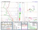
Bit of a weird hodograph. You can see a little bit of the cap still there, but it’s southwest of the main action right there so may not be totally representative of the environmentLatest sounding from LZK.