KevinH
Member
Here is the schedule:Whens the update coming out for day 2? Considering staying up to see what it looks like.

Follow along with the video below to see how to install our site as a web app on your home screen.
Note: This feature may not be available in some browsers.
Here is the schedule:Whens the update coming out for day 2? Considering staying up to see what it looks like.
Quite the helpful 3d animation by Brandt on how hodographs are structured in soundings for beginners.
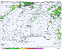
Did you get this from https://kamala.cod.edu/SPC/ ?View attachment 37611
Well hello, you look familiar…
Still differences between models on widespread convection etc for a MDT
Now to bed…
April looks subdued after you get past the very beginning of the month budWait until April
April looks subdued after you get past the very beginning of the month bud
I don’t think we can make any sort of statement, one way or the other, on which way April will go this far out. After the 3/14 outbreak, it looked quiet on the models for a few weeks, so it really just depends. Especially if that signature comes back through.April looks subdued after you get past the very beginning of the month bud
Well granted I’m not a fan of the guy but Dr. Reed agrees. The pattern shifts to a NW flow which isn’t conducive for severe weather for us. What basis are you making that statement on? Mine is based off computer model data, and another meteorologist.I would say given how March has progressed, I wouldn’t be downplaying the bulk of April just yet.
Care to post that over in the Severe Wx 2025 thread?Well granted I’m not a fan of the guy but Dr. Reed agrees. The pattern shifts to a NW flow which isn’t conducive for severe weather for us. What basis are you making that statement on? Mine is based off computer model data, and another meteorologist.
Well granted I’m not a fan of the guy but Dr. Reed agrees. The pattern shifts to a NW flow which isn’t conducive for severe weather for us. What basis are you making that statement on? Mine is based off computer model data, and another meteorologist.
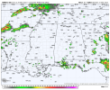
How does it look for TN? I don’t have access to the 6z.The euro continues to stick with its guns on a more isolated line of supercells for Mississippi and Alabama.
I can see perhaps a week or so break from this pattern , but this pattern is far from over , It will return mid April with Avenge…..Care to post that over in the Severe Wx 2025 thread?
It's isolated as well, the EURO has been very consistent on more discrete/semi discreet supercells. Just a few mesoscale feature shifts away from a outbreak in Mississippi and Alabama.How does it look for TN? I don’t have access to the 6z.
The condescension from the beginning isn’t appreciated. I used “bud” because there was no basis for his statement. You assume I don’t have any experience. How does your experience override a NW flow pattern that is coming in the middle to late April? The models are on board with this idea.you got me “bud”. Mine is based off of living thru both the April 3, 74 and the April 27, 2011 outbreaks on the ground in Alabama.