CheeselandSkies
Member
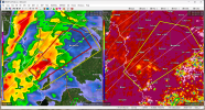
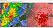
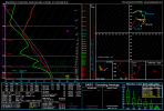
Impressive tornado warning moving into Louisiana. Donut hole on it
Went from no warning to SVR to TOR in the space of three (every two minute) radar scans. Possibly already a slight CC drop with it, too.
Follow along with the video below to see how to install our site as a web app on your home screen.
Note: This feature may not be available in some browsers.
Impressive tornado warning moving into Louisiana. Donut hole on it
Just reading MEG's discussions leading up to March 24th. They were harping about how the CAPE/Instability weren't there (much like they're doing with this upcoming event and every other event since). Expectation was for strong tornadoes to just occur in the Delta Region and everything congeal into a squall line near/or just after Sunset. From their afternoon discussion March 24th, 2023: "If these discrete cells can form in the warm sector, strongDon't know if I'm the only one getting slight March 24th 2023 (Rolling Fork vibes) - not to say that will happen again, in any form - but the compact embedded trough with a fairly broad warm sector, anomalous instability and consistent uptrends in a similar region have me thinking this should be watched closely.
The fact the word-class experts have gone for a 30% SIG at D3 does suggest the potential for something noteworthy... let's hope not.
Events this time of year are so often about "just enough" of one ingredient or another that I would think it very unwise to downplay a setup hard when there's ample instability forecast in the presence of strong kinematics. The presence of a large D3 ENH should raise anyone's eyebrows.Just reading MEG's discussions leading up to March 24th. They were harping about how the CAPE/Instability weren't there (much like they're doing with this upcoming event and every other event since). Expectation was for strong tornadoes to just occur in the Delta Region and everything congeal into a squall line near/or just after Sunset. From their afternoon discussion March 24th, 2023: "If these discrete cells can form in the warm sector, strong
tornadoes are possible." Only thing is the Amory Tornado came from the same Supercell that produced the Rolling Fork tornado and the Winona tornado.
2024 wouldn't end without letting MS get in on the action.And if it does, it'll be in yours truly's backyard. LOL! That's been the running joke ever since last year in my meteorology text group. The crazy thing is I dreamed about the Amory tornado happening and the February 16th, 2023 EF1 tornado that hit 2 miles west of my house roughly 10 years prior. Both in the exact same locations as in my dream.
Nope! I mean you kinda of expected it given how lackluster and eerily quiet Spring ended up.2024 wouldn't end without letting MS get in on the action.
Deep South was fairly quiet this spring, except for that really weird event in TN and northern AL in May. That was one strange outbreak.Nope! I mean you kinda of expected it given how lackluster and eerily quiet Spring ended up.
O yeah. Forgot about that one. That was a bit odd.Deep South was fairly quiet this spring, except for that really weird event in TN and northern AL in May. That was one strange outbreak.
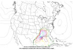
SPC Severe Weather Event Review for Wednesday May 08, 2024
www.spc.noaa.gov
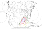
18z GFS and NAM CWASP aren't ideal eitherLast frame of 00Z HRRR is not ideal for those of us in the Deep South. Wave after wave of supercells and QLCS.
View attachment 32007
Indeed. I've already been alerting my EMA director about it. The most concerning aspect is everything starts to bubble after Sunset.A little bit late to this discussion, but Saturday looks increasingly worrying for the Southern states like Mississippi.
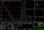
Getting tired of seeing this. Last month in Oklahoma and now here in Louisiana.Got us a powerful unwarned tornado south of KPOE radar. What the heck are they doing?
Yeah. I noticed that. Even has a debris signature! Good Lord!Got us a powerful unwarned tornado south of KPOE radar. What the heck are they doing?
Referring to warning issuance.Getting tired of seeing this. Last month in Oklahoma and now here in Louisiana.