• Welcome to TalkWeather!
    We see you lurking around TalkWeather! Take the extra step and join us today to view attachments, see less ads and maybe even join the discussion.
    CLICK TO JOIN TALKWEATHER

Severe WX Wednesday/Thursday/Friday April 17th-19th Severe Threat

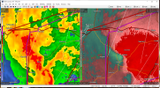
HRRR still on board with a pretty wicked bow coming through N AL.

hrrr_ref_frzn_seus_9.png
This places the bowing segment considerably farther north than previous runs. Maybe some 50-60 miles.
 
Gonna be a classic QLCS tornadofest across parts of MS, I can see that right now. We'll see if any of the junk stuff out ahead can develop and maintain supercell structures long enough to take advantage of the environment; I don't usually have too high hopes for cells this close to the coast
 
PDS warning in MS now from NWS Jackson:

...A TORNADO WARNING REMAINS IN EFFECT UNTIL 245 PM CDT FOR HINDS AND
NORTH CENTRAL COPIAH COUNTIES...

At 211 PM CDT, a confirmed large and extremely dangerous tornado was
located 7 miles southwest of Raymond, or 14 miles southwest of
Clinton, moving northeast at 45 mph.

This is a PARTICULARLY DANGEROUS SITUATION. TAKE COVER NOW!

HAZARD...Damaging tornado.

SOURCE...Radar confirmed tornado.

IMPACT...You are in a life-threatening situation. Flying debris may
be deadly to those caught without shelter. Mobile homes
will be destroyed. Considerable damage to homes,
businesses, and vehicles is likely and complete destruction
is possible.
 
Radarscope seems to be working for me right now, but if it fails tonight when things start happening here in North Alabama, it'll be their second outage on a day with possible severe weather IMBY in the last month or so. That isn't what I paid $10 for.
RadarScope has issues more than it should. Thinking of something else come renew time.
 
NWS Jackson posted on Facebook:

Confirmed tornado was spotted along Dry Grove Road in Raymond along Highway 18. Stay in your safe place and take cover now!!
 
Looks like another radar confirmed tornado in MS:

* Tornado Warning for...
Southeastern Rankin County in central Mississippi...
Simpson County in central Mississippi...

* Until 345 PM CDT.

* At 240 PM CDT, a tornado producing storm was located near
Harrisville, or 10 miles west of Pinola, moving northeast at 35
mph.

HAZARD...Damaging tornado.

SOURCE...Radar confirmed tornado.

I think they said there was a TDS on this one per the ABC affiliate in Jackson

Said it was over Harrisville heading towards Braxton...

Wow, that really tightened up on the radar heading towards Braxton...
 
Last edited:
Back
Top