Equus
Member
It's fantastic to have local geographical knowledge offered during these events imo, though not so good when that means that an area one knows very well is under severe threat
Follow along with the video below to see how to install our site as a web app on your home screen.
Note: This feature may not be available in some browsers.
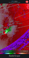
another photo of the storm that passed near my parents' house near Byron
This was looking like a Central/East AL into West/Central GA just a few days ago. Things just shifted Southeast with time. But someone was getting hit.I never would have thought we'd have potentially broken our violent tornado-less streak today of all days. Speechless
This was looking like a Central/East AL into West/Central GA just a few days ago. Things just shifted Southeast with time. But someone was getting hit.
for west-central Georgia? like the Macon TV market? probably 3/1/07.Help me out here but has this has been the most significant day for that particular area since 3/1/07? 1/22/17?
That is crazy.unfortunately once that thing gets east of 75 it's pretty much all populated areas. there are a lot of subdivisions between Warner Robins and Perry.
200 mph gate to gate shear (off of FFC but still, that has to be nasty at ground level). this one might be almost as strong as the Lee County storm. I think they need to go tornado emergency on this.
for west-central Georgia? like the Macon TV market? probably 3/1/07.
I feel weirdly personally guilty about this since it's my "hometown" radar. The Macon TV mets are...definitely not happy about it.Something's gotta be done with Warner Robbins radar, always being down in outbreaks. Not having low level scans there today is a VERY bad thing.