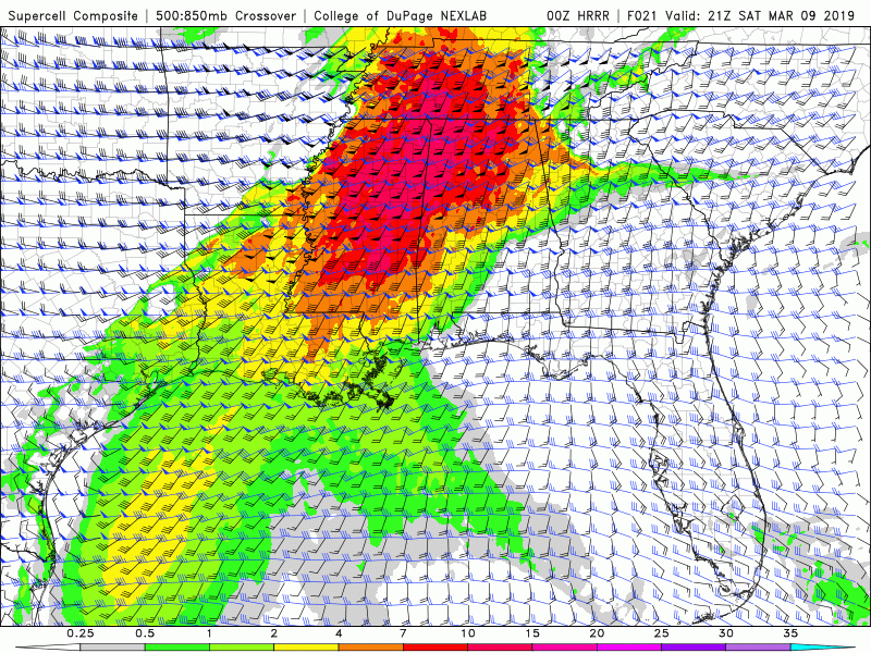
• Welcome to TalkWeather!
    We see you lurking around TalkWeather! Take the extra step and join us today to view attachments, see less ads and maybe even join the discussion.
    CLICK TO JOIN TALKWEATHER
  • April 2024 Weather Video of the Month
    Post your nominations now!

Severe WX Southern Severe Weather Threat: 3/9-3/10

Austin Dawg

Member
Sustaining Member
Messages
881
Reaction score
1,352
Location
Leander, Texas
pds.jpeg
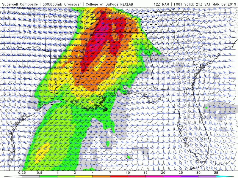
Sat 2019-03-09 09z NAM looks crazy in OK north Texas and just moves it east through ARK, LA to TN and MS.

Or is this just a newbie misreading things?pds 2.jpeg
 

Taylor Campbell

Moderator
Moderator
PerryW Project Supporter
Messages
2,138
Reaction score
2,242
Location
Wedowee, AL
Special Affiliations
  1. SKYWARN® Volunteer
Dang! The NAM is coming around as well!

NAM-trend-SCP.gif
 

Austin Dawg

Member
Sustaining Member
Messages
881
Reaction score
1,352
Location
Leander, Texas
NAM STP from Sat 2019-03-09 09z thru Sun 2019-03-10 09z is showing TOR soundings in North Texas, SE OK, moving thru ARK and Northern LA into West TN and Northern 2/3rds of MS. I wish I knew how to make the animated gif and save it. But I would feel better if one of you seasoned guys took a look to see if it may be overplaying the conditions. It's showing some pretty high numbers on the STP.

ETA: My techy nerd self was able to make one after all. Does this look a bit overblown to you guys?

floop-nam-2019030900.stp.conus.gif
 

KoD

Moderator
Staff member
Moderator
Sustaining Member
PerryW Project Supporter
Messages
1,380
Reaction score
697
Location
Huntsville, AL
I've noticed capping inversion around 800mb in N MS on many of the runs. I wonder if this will end up throwing a wrench in storm development in areas east of the current outlook (and southern sectors of the current outlook region) ... I think we got a lot of strong parameters in play here, but I see elements that make this a tricky forecast. I don't envy NWS/SPC that's for sure!
 
Messages
2,862
Reaction score
4,675
Location
Madison, WI
Definitely a curveball on the 0Z models. HRRR and 12K NAM ratcheted things up big time depicting a very dangerous environment, while 3K NAM remains more subdued.
 

Taylor Campbell

Moderator
Moderator
PerryW Project Supporter
Messages
2,138
Reaction score
2,242
Location
Wedowee, AL
Special Affiliations
  1. SKYWARN® Volunteer
A look at the HRRR, GFS, NAM, and RAP valid 21z tomorrow.

Model-Comparison-21z.gif
 
Messages
2,862
Reaction score
4,675
Location
Madison, WI
NAM STP from Sat 2019-03-09 09z thru Sun 2019-03-10 09z is showing TOR soundings in North Texas, SE OK, moving thru ARK and Northern LA into West TN and Northern 2/3rds of MS. I wish I knew how to make the animated gif and save it. But I would feel better if one of you seasoned guys took a look to see if it may be overplaying the conditions. It's showing some pretty high numbers on the STP.

ETA: My techy nerd self was able to make one after all. Does this look a bit overblown to you guys?

View attachment 1156

STP tells you there is a favorable environment, but it doesn't tell you whether there will be sustained convection in a favorable mode (discrete supercells) to utilize it to its fullest. Right now it appears to me the HRRR suggests there will be, while the 3K NAM shows things remaining weaker (not sure why).
 
Messages
21
Reaction score
39
Location
Bossier City, LA
00z NSSL WRF is about what I've been expecting out of tomorrow. EML looks to come in a little stronger and forcing not able to overcome it in the morning. The result is increased instability and an overall more concerning severe weather threat for most of Mississippi and western Tennessee, NW Alabama.

Discrete/semi-discrete supercell modes look quite likely tomorrow.. Could be a pretty intense environment out there. More favorable track/timing is responsible for the uptick in kinematics.
 

Austin Dawg

Member
Sustaining Member
Messages
881
Reaction score
1,352
Location
Leander, Texas
STP tells you there is a favorable environment, but it doesn't tell you whether there will be sustained convection in a favorable mode (discrete supercells) to utilize it to its fullest. Right now it appears to me the HRRR suggests there will be, while the 3K NAM shows things remaining weaker (not sure why).

Thanks! I thought it looked waaay worse than the discussions I have read.
 

Timhsv

Member
Messages
457
Reaction score
805
Location
Huntsville, AL.
Special Affiliations
  1. SKYWARN® Volunteer
Jason WHNT on FB, chat shows the new model data with EHI 5-6 and he is very concerned if those do verify. All depends on the uncertainty in the morning rainfall. I still stand by what I posted with the numbers yesterday, With the new model data and the parameters going up and uncertainty with the morning cloud cover, I would suspect SPC will pull back further east and south on the new Day1 IMO. We'll see. I mean the NAM has a 991 and the new GFS has a 989. You cannot ignore that even if its in Northern MO.

We now have an 4.5 EHI and PDS Sounding at between Greenwood, MS to I-55 at 21Z Saturday

nam_2019030818_027_33.09--90.29.png
 
Last edited:
Back
Top