Tornado watch coming soon for parts of Western TN, KY, IL, MO, and AR
Concerning...Severe potential...Watch likely
Valid 091545Z - 091815Z
Probability of Watch Issuance...80 percent
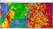
SUMMARY...Scattered severe storms are expected to develop through
afternoon from northeast Arkansas across northern Mississippi and
toward the Lower Ohio Valley. A few tornadoes and damaging winds
will be possible.
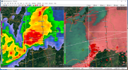
DISCUSSION...A warm front continues to lift north across eastern AR
and now into southeast MO and western KY, with rapidly increasing
shear profiles. While instability is weak, a line of storms along a
cold front over AR, and any additional storms that develop ahead of
the upper vorticity max, may have the potential to produce tornadoes
and/or damaging winds. Instability will be the main limiting factor,
but excessive shear profiles and favorable large-scale lift may
mitigate this.
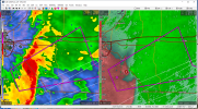
Southern parts of the line will move slower across southern AR into
MS, but here instability will be stronger, and hodographs will
clearly favor supercells.