
Navigation
Install the app
How to install the app on iOS
Follow along with the video below to see how to install our site as a web app on your home screen.
Note: This feature may not be available in some browsers.
More options
-
Welcome to TalkWeather! We see you lurking around TalkWeather! Take the extra step and join us today to view attachments, see less ads and maybe even join the discussion. CLICK TO JOIN TALKWEATHER
You are using an out of date browser. It may not display this or other websites correctly.
You should upgrade or use an alternative browser.
You should upgrade or use an alternative browser.
Southeast Svr Wx threat April 8-11, 2024
- Thread starter KevinH
- Start date
CheeselandSkies
Member
Storms along the TX/LA line in the 10 hatch have really struggled to look like anything other than rainy blobs despite strong shear. Some rotation south of Kirbyville, TX but it's not currently warned; even SVR.
Edit: Looking a bit more impressive, they might actually want to warn it.
Edit: Looking a bit more impressive, they might actually want to warn it.
Attachments
warneagle
Member
WHAT TIME IS THE ECLIPSE WEDGE GOING TO HIT MY HOUSE??????I think you're giving the general public too much credit my friend. No matter how perfect a forecast turns out to be, there's always gonna be some group of people who will look for an excuse to complain no matter what...
View attachment 25260
wx_guy
Member
- Messages
- 1,237
- Reaction score
- 4,443
- Location
- United States
- HAM Callsign
- KO4ZGH
- Special Affiliations
- SKYWARN® Volunteer
- ARRL Member
So a coding challenge I worked on this evening: What could a "verified" forecast look like?
I made a program that takes in the latest SPC convective risks and simulates a tornado outbreak. (I don't have it for hail or high winds atm.) An orange dot represents a tornado touching down at that spot. A white dot represents an EF2+ tornado touching down at that spot.
I'll show a few random runs -- each run is different, but the probabilities are based on the SPC's probabilities.
I have 7 shown here, and these are NOT cherry-picked: They are literally the 7 runs in a row I did just for this post. I think it's a helpful visual to see that even "busts" can be valid probability-wise, and the probabilities allow for a wide range of scenarios.
Now to wait for the new Day 1 to hit lol
Posted on Facebook that the threat will say along and south of I-20 tonight. Still had people commenting us about towns in North MS.WHAT TIME IS THE ECLIPSE WEDGE GOING TO HIT MY HOUSE??????
Awesome work! The natural statistical variation is really neat, and is a rather good example of the breadth of possible outcomes you can get with any given setup.So a coding challenge I worked on this evening: What could a "verified" forecast look like?
I made a program that takes in the latest SPC convective risks and simulates a tornado outbreak. (I don't have it for hail or high winds atm.) An orange dot represents a tornado touching down at that spot. A white dot represents an EF2+ tornado touching down at that spot.
I'll show a few random runs -- each run is different, but the probabilities are based on the SPC's probabilities.
I have 7 shown here, and these are NOT cherry-picked: They are literally the 7 runs in a row I did just for this post. I think it's a helpful visual to see that even "busts" can be valid probability-wise, and the probabilities allow for a wide range of scenarios.
Now to wait for the new Day 1 to hit lol
View attachment 25274
View attachment 25275
View attachment 25276
View attachment 25277
View attachment 25278
View attachment 25279
View attachment 25280
 ~
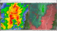
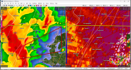
~These are probably the strongest QLCS associated radar velocities I can recall seeing... 130mph. Not only that, there are at least 4 tornadic circulations in the single tornado warning alone. Another reminder to never underestimate QLCS events - especially considering we will most likely see similar stuff to this continuing across LA, MS and AL for the next 12 hours. Still think the 15% was the right call from the SPC.
Justin Hindman Hindy
Member
I'll eat crow if I am wrong. My thinking today is a lot of wind reports today. A few tornadoes that will be embedded which could be strong for a few minutes. I will be surprised if we see any videos of visual tornadoes unless it's along the beach. A 300 plus wind report day with 5-10 reports of tornadoes..
CheeselandSkies
Member
First benefit of KHDC realized - it got a much better look at the earlier tornado-warned supercell near Rosedale, LA than KLIX would have, and the storm was about the same distance from KLCH.
It's also getting a better look at the newly warned QLCS circulation approaching Saint Francisville than would have been possible before.
It's also getting a better look at the newly warned QLCS circulation approaching Saint Francisville than would have been possible before.
CheeselandSkies
Member
Ledian
Member
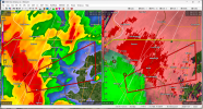
Possibly. Wasn't expecting that PDS warning to come out of nowhere...Possible TDS at St. Francisville?
Baton Rouge is about to take a beating.
CheeselandSkies
Member
Ugh. IMO they should NEVER pair "large and extremely dangerous tornado"/PDS verbiage with "radar indicated rotation." To use the former it should be "radar confirmed tornado" via a large, deep and persistent TDS; or preferably confirmed via spotter reports.
wx_guy
Member
- Messages
- 1,237
- Reaction score
- 4,443
- Location
- United States
- HAM Callsign
- KO4ZGH
- Special Affiliations
- SKYWARN® Volunteer
- ARRL Member
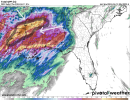
Just released the new D1 MDT for 13z.
Here's the tornado threat, with a couple of simulations (see previous post) of the tornadoes. (Please note these are probabilistically-generated points, not based on any meteorology other than the SPC's numbers.)


Here's the tornado threat, with a couple of simulations (see previous post) of the tornadoes. (Please note these are probabilistically-generated points, not based on any meteorology other than the SPC's numbers.)
wx_guy
Member
- Messages
- 1,237
- Reaction score
- 4,443
- Location
- United States
- HAM Callsign
- KO4ZGH
- Special Affiliations
- SKYWARN® Volunteer
- ARRL Member
Yeah, that's weird and probably a bad idea for them to do.Ugh. IMO they should NEVER pair "large and extremely dangerous tornado"/PDS verbiage with "radar indicated rotation." To use the former it should be "radar confirmed tornado" via a large, deep and persistent TDS; or preferably confirmed via spotter reports.
cincywx
Member
Ugh. IMO they should NEVER pair "large and extremely dangerous tornado"/PDS verbiage with "radar indicated rotation." To use the former it should be "radar confirmed tornado" via a large, deep and persistent TDS; or preferably confirmed via spotter reports.
completely agree. i will say, WAFB [baton rouge] just reported on air that the nws said they used the wrong product in issuing that TOR.
CheeselandSkies
Member
Ironically, KLIX would be shooting the currently warned cell at just a couple hundred feet if it were still "live."
wx_guy
Member
- Messages
- 1,237
- Reaction score
- 4,443
- Location
- United States
- HAM Callsign
- KO4ZGH
- Special Affiliations
- SKYWARN® Volunteer
- ARRL Member
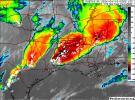
This is the NSSL CAM experimental model using the MPAS-RT, but many of the CAMs are starting to show this same pattern -- a dangerous bow echo, not dissimilar from a derecho, speeding across south AL/north FL later this evening. If this verifies, strong winds over 65-70 mph appears very plausible, and the SPC might need to extend the hatched wind risk further east into AL/FL.

Just released the new D1 MDT for 13z.
Here's the tornado threat, with a couple of simulations (see previous post) of the tornadoes. (Please note these are probabilistically-generated points, not based on any meteorology other than the SPC's numbers.)
Do you think you could post the source code to Github or whatever, so that we can try our own hands at running some simulations ourselves? Because this looks quite fascinating to me, enough so that I want to try my hand at generating some simulations myself just to see what kinds of results that would produce!
