- Moderator
- #121
Live Storm Chasing
Watch live feeds as storm chasers try to see if their target verifies. Tornadoes, hurricanes, blizzards, and floods - we've got it all and more, live on our site and available as video on demand.
Follow along with the video below to see how to install our site as a web app on your home screen.
Note: This feature may not be available in some browsers.

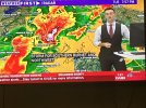
Ok so what's up with that? Is that a radar problem or an issue with RadarScope?Love the 8 minutes between scans on the KDGX radar...
Ok so what's up with that? Is that a radar problem or an issue with RadarScope?
Interestingly, 0Z HRRR depicts the ongoing tornado-warned QLCS along and west of I-55 in MS as much more discrete supercells than reality at just FH02. Casts its accuracy for the rest of the run in doubt IMO...
So essentially a useless radar in a fairly populated area, wonderful.Long-term issue with that particular radar site. Shows up across viewing platforms including GR Level 3.
Thankfully, there are just 4-5 minutes on WSV3, but it's still too long.Love the 8 minutes between scans on the KDGX radar...
Do y'all think the moderate might get expanded further north when the D1 comes out?
Honestly I don't believe so. Now the Moderate Risk for Excessive Rainfall? Yes especially based on that discussion above.Do y'all think the moderate might get expanded further north when the D1 comes out?