pritchlaw
Member
I guess the atmosphere can recover, but it is flat-out chilly and cool with rain in Central Alabama. The definition of stable.
Follow along with the video below to see how to install our site as a web app on your home screen.
Note: This feature may not be available in some browsers.
I think you're giving the general public too much credit my friend. No matter how perfect a forecast turns out to be, there's always gonna be some group of people who will look for an excuse to complain no matter what...Even if you had a strict criteria, you would still have people hollering BUST before the event even started. LOL! Tomorrow honestly looks like a widespread damaging wind event than tornado outbreak. There's still gonna be tornadoes. If the general public just knew what all goes into forecasting these events, we would be set atop a mountain and hailed as heroes

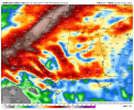
The SPC issues a 60% hatched area for extremely violent tornadoes. Some people complain because there was a few more tornadoes in the 45% hatched area than the 60% hatched. There were also a few more long tracked tornadoes in the 15%, 30%, and 45% hatched areas. We could go on forever.I think you're giving the general public too much credit my friend. No matter how perfect a forecast turns out to be, there's always gonna be some group of people who will look for an excuse to complain no matter what...
View attachment 25260
I have no idea lol. I just know there's potential tommorow for the atmosphere too cook with some tornadoes lolWhat does abs calibrated mean? And how does it different from the “2022” model version.
Great question! The absolutely calibrated Nadocast model differs from the "standard" calibration that is advertised on its main Twitter page, and there's a reason the Abs Cal version is hidden deep in its data archives. The Abs Cal version is basically the raw, unadjusted probabilities it spits out. The algorithm then standardizes it to the SPC's risk probabilities for its standard 2022 version. Thus, on the regular Nadocast, a 15% corresponds to a 15% from the SPC. On the Abs Cal version, a 15% corresponds to nothing, it's just the raw output probability. So when people post the Abs Cal version, it's usually higher and more hype-ified and click-tastic than the normal version. The normal version can somewhat be compared, apples to apples, with the SPC's probabilistic scheme.What does abs calibrated mean? And how does it different from the “2022” model version.
Ok coolGreat question! The absolutely calibrated Nadocast model differs from the "standard" calibration that is advertised on its main Twitter page, and there's a reason the Abs Cal version is hidden deep in its data archives. The Abs Cal version is basically the raw, unadjusted probabilities it spits out. The algorithm then standardizes it to the SPC's risk probabilities for its standard 2022 version. Thus, on the regular Nadocast, a 15% corresponds to a 15% from the SPC. On the Abs Cal version, a 15% corresponds to nothing, it's just the raw output probability. So when people post the Abs Cal version, it's usually higher and more hype-ified and click-tastic than the normal version. The normal version can somewhat be compared, apples to apples, with the SPC's probabilistic scheme.
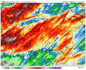
They said we were in for a fun night.Storm south of Brady TX also has a very intense meso aloft. Considering the dewpoints are still in the 70s north of the boundary, I don't see much reason why these can't thrive, much like the recent HRRR runs have shown through Central TX.
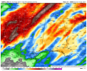
Not so sure about the SREF but the NAM seems to depict relatively little precip aside from what we've got going on right now and what will be happening later tomorrow, so I think it's probably underdoing convection compared to other models.Model and weather question both here. Why is the NAM models and SREF ARW so off with the displacement of the highest precip totals?
Leading up this event, the SREF ARW had the highest precip where the WPC had it across MS.
All of the MPAS members agree with the HRRR that the QLCS basically removes most of the instability. The QLCS looks very intense though.18z HRRR seems to be the outlier for a more confined coastal threat. I think the 18z HRRR run is a fluke. 00z and moving forward will probably come closer to the WRF runs. There's potential tommorow for a long track significant tornado or two. But man I wouldn't bet on it, will know more as the event approaches tomorrow morning. Defiantly would not chase this, unless you just want to see sheets of rain falling from the sky.
If I were a betting man a couple of confluence band supercells may pop up in the south Mississippi/ east Louisiana area.. if not your just looking at a MCS with embedded meso vortices. Huge damaging wind threat tomorrow though I think.