TH2002
Member
- Messages
- 4,973
- Reaction score
- 11,113
- Location
- California, United States
- Special Affiliations
- SKYWARN® Volunteer
Okay thanks for clearing that up!It's from Grazulis's site and he lists it as from the Thurman tornado
Follow along with the video below to see how to install our site as a web app on your home screen.
Note: This feature may not be available in some browsers.
Okay thanks for clearing that up!It's from Grazulis's site and he lists it as from the Thurman tornado


So, since my article obviously won't be ready for today's anniversary, I wanted to at least share something. This is simply the most remarkable series of tornado photos I've ever seen, and I'm not sure it's even close. It's not clear exactly who took them, but they were taken from near the intersection of Broadway & Spearman avenues in Wheatland, looking to the south and southeast. This would've been almost exactly half a mile from the core of the tornado (this is the full width of the path, remember - the core is much narrower):

Anyway, the first photo here is taken when the tornado is roughly near the river.

By the second photo, you can already see it striking Yourga Trucking. I believe the huge piece of debris here is the roof, most of which was ripped off in one piece, crumpled up and tossed over a quarter-mile into someone's yard.

I think it's probably tearing up Wheatland Tube here, which is right next door.

In the next few photos, it's likely demolishing Sawhill Tubular and a number of homes scattered around it. The third photo especially gives you a better view of just how small the core is relative to the entire funnel/circulation.


Though the damage throughout this area is exceptionally intense, arguably the most violent damage along the entire path occurs as the tornado crosses the railroad tracks, growing a bit larger as it utterly obliterates a number of homes, businesses and industrial buildings.


Basically the entire funnel swarms with debris as it finally speeds away across an unpopulated area.


Oh yeah, forgot to include that one. I think the crazy thing is that the very center of the tornado actually didn't directly hit a lot of the industrial buildings. It was very close, obviously, but many of the buildings were sort of on the northern edge of the core. It's hard to imagine the damage being much worse either way, but who knows.This photo I posted of it earlier in the thread and it's likely a remastered photo for the first one in the series you posted:
I'm pretty sure that near the bottom left of the tornado's path you can see sheet metal being lifted from an orange-tinted building (almost certainly Yourga Trucking) as the funnel plows through the area. It seems like the core of this tornado directly hit Yourga and several of the industrial buildings in Wheatland's main district, would you say that the tornado was likely at peak intensity in this area?
Also, your bit about how the exact fatality count from this outbreak is likely uncertain doesn't surprise me; I have a suspicion that ~100 people died in this outbreak (counting Canadian as well as US side) but for a variety of reasons not all fatalities were fully accounted for. Amazing how violent this event was.
This reminds me of one of the findings from the 5/3/99 FEMA BPAT report. Several of the shelters and other structures they inspected had ballasted EPDM roofs (EPDM held in place by a heavy layer of aggregate), and they found that in some cases the ballast became airborne and caused significantly increased damage.This is Abuelo’s, a restaurant I worked at in high school and part of college. This chain was founded in Texas, and the buildings are specifically engineered to be more tornado resistant than your typical chain restaurant. My boss told me it was designed to survive a direct hit from a 120 MPH (mid-EF2) tornado, which it barely did. One of the most interesting things I noticed in this area was many, many decorative rocks that were swept from flower beds and left embedded in the stucco exterior walls of the building, like it had been fired at by a massive shotgun. Wooden chairs from the dining area were also sucked through two sets of front double doors and left in the front lot. The rocks and chairs are clearly visible below:
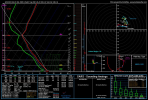
Silly question, for the tornado paths, what tools do you use to make the paths wider or shorter....I know how to measure a distance in google maps but no clue on how to make the paths wider to account for tornado damage swaths? Not sure how to phrase my question.I still have some stuff to add, but here's the full 5/31/85 map so far:
To me, it's especially striking to see how concentrated the fatalities are - nearly all of them in the US occurred within an area of about a hundred square miles.
I suppose by "condensation funnel" I meant outer circulation (the portion that surrounds the core and subvortices from view) but now I understand tornadic winds are more complicated then I previously thought.Broadly speaking, I would guess that the most violent tornadoes are probably more likely to be multivortex just because of the way swirl ratio works. Very much generalizing here, but if you think about the airflow in a tornado, air is drawn into/around the central low-pressure area and then has to "turn the corner" and be lifted upward. The region where that happens, appropriately enough, is called the corner flow region. That's basically what we think of as "the core," where the most extreme winds occur.
Anyway, the more momentum that air coming into the corner flow region has, the harder it is to lift it upward and the higher the swirl ratio. At a certain point, the momentum is such that the flow breaks down and forms into multiple smaller vortices. Since momentum = mass * velocity, you can see how a tornado with higher horizontal (more specifically tangential) velocities might be more likely to break down into multiple vortices.
Again, I'm simplifying and glossing over a ton of important stuff (updraft strength, debris loading, surface roughness, etc), but that's the general idea as I understand it.
As to your question, I'm not quite sure how to answer it. The condensation funnel itself is just a function of the local pressure deficit and humidity of the air. The wind field in a tornado is really complex and can change pretty rapidly, which you can sort of see in the radically different damage gradients/patterns. And then you can sometimes get particularly intense inflow jets and weird things like the "inflow vortices" that Greg Forbes described w/several of the 5/31/85 tornadoes, etc. They occur well outside of the core (and often outside of the funnel altogether) but can still produce pretty violent winds.
Great work!I still have some stuff to add, but here's the full 5/31/85 map so far:
To me, it's especially striking to see how concentrated the fatalities are - nearly all of them in the US occurred within an area of about a hundred square miles.


Looks like there was another major tornado outbreak in China.


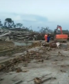
Wow it completely swept away homes. Do you have any photographs of that damage?It's almost impossible to have this condition to have a regional outbreak even in America, or maybe the whole world....
View attachment 9728
The violent, drillbit tornado which hit ShangZhi, HeiLongJiang Province maybe the strongest one of this outbreak.Already seen houses completely swept away, high voltage tower totally collapsed....at least EF3 I think.
View attachment 9729View attachment 9730View attachment 9731
The atomsphere is forecasted to be much more volatile tomorrow afternoon and evening, with decent shear and CAPE exploding in several Province in Northern and Northern Parts of China. So the outbreak hasn't come to an end....
It's pretty weird to have such an active tornado season in China for almost ten years, maybe more. What's more, most of the reports all came from the past month, which means, we're now dealing with one of the most active May in Chinese history, however, on the other side of the Planet, traditional Great Plains seem to have underperformed.
It's almost impossible to have this condition to have a regional outbreak even in America, or maybe the whole world....
View attachment 9728
The violent, drillbit tornado which hit ShangZhi, HeiLongJiang Province maybe the strongest one of this outbreak.Already seen houses completely swept away, high voltage tower totally collapsed....at least EF3 I think.
View attachment 9729View attachment 9730View attachment 9731
The atomsphere is forecasted to be much more volatile tomorrow afternoon and evening, with decent shear and CAPE exploding in several Province in Northern and Northern Parts of China. So the outbreak hasn't come to an end....
It's pretty weird to have such an active tornado season in China for almost ten years, maybe more. What's more, most of the reports all came from the past month, which means, we're now dealing with one of the most active May in Chinese history, however, on the other side of the Planet, traditional Great Plains seem to have underperformed.

I use the polygon tool in Google Earth and then export the kmz to Google Maps.Silly question, for the tornado paths, what tools do you use to make the paths wider or shorter....I know how to measure a distance in google maps but no clue on how to make the paths wider to account for tornado damage swaths? Not sure how to phrase my question.
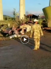
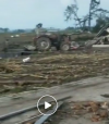
The three people who died at that location were in a car that was thrown several hundred yards. Another person who was about half a mile ahead of them got out of his truck and hid in a ditch, and it's a good thing he did - his truck was thrown eight-tenths of a mile and completely mangled.Great work!
Now this is somewhere I would NOT want to be. I feel really bad for those who lost their lives here, they had absolutely no chance against the Tionesta Tornado. Their final moments must have been horrible.
View attachment 9725
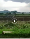
Given how massive the Tionesta Tornado was, there was just no way out of it. It started as a gigantic twister and stayed that way for a good portion of its life. I wonder if any photos from that area exist.
View attachment 9726
Does anyone have any damage photographs that show the reportedly swept away homes from the Shangzhi tornado in China?