
Close ups show bolts, but the CMU foundation itself could definitely be considered a structural weakness. But yeah, site-built homes are not supposed to be rated lower than EF3 when swept away.Was that house well-bolted to the foundation? Whether the house was bolted or not however I'm pretty sure they broke the constraints of the EF scale which doesn't normally allow swept away frame homes to be rated lower than EF3.
Navigation
Install the app
How to install the app on iOS
Follow along with the video below to see how to install our site as a web app on your home screen.
Note: This feature may not be available in some browsers.
More options
-
Welcome to TalkWeather! We see you lurking around TalkWeather! Take the extra step and join us today to view attachments, see less ads and maybe even join the discussion. CLICK TO JOIN TALKWEATHER
You are using an out of date browser. It may not display this or other websites correctly.
You should upgrade or use an alternative browser.
You should upgrade or use an alternative browser.
Significant Tornado Events
- Thread starter locomusic01
- Start date
TH2002
Member
- Messages
- 4,973
- Reaction score
- 11,113
- Location
- California, United States
- Special Affiliations
- SKYWARN® Volunteer
Do you think the house could have been assigned a rating in the EF4 range?Close ups show bolts, but the CMU foundation itself could definitely be considered a structural weakness. But yeah, site-built homes are not supposed to be rated lower than EF3 when swept away.
Context isn’t consistent with a violent tornado, so no.Do you think the house could have been assigned a rating in the EF4 range?
Casuarina Head
Member
It is very difficult to see how this could not be rated EF4 but Newnan GA could. This is clearly more intense damage than the latter.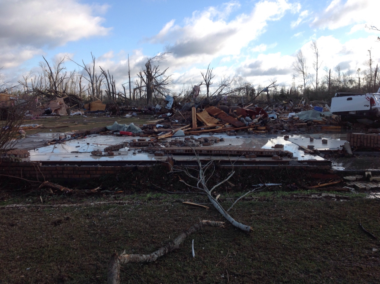
Is this the home that was swept away by the 2014 Columbia tornado?
That's pretty phenomenal.
Brice Wood
Member
That's pretty phenomenal.
Shows how intense this tornado really was
Juliett Bravo Kilo
Member
Bridge Creek-Moore's path is still visible years later in satellite images. A trail of deforestation can be seen at bottom left near Bridge Creek, and the northerly turn the tornado made in Del City is visible at top right.Shows how intense this tornado really was

- Thread starter
- #4,208
locomusic01
Member
Yeah, I had no idea how unusual the paths were until I started mapping them out. Whenever the article's done I'm gonna post the full interactive map. I've also been plotting the deaths for each tornado since they aren't really well-documented. Also had to make changes to a few of the tracks once I got more information. Still have a few more tracks to add and I haven't located the deaths for a couple of the tornadoes yet, but everything should be accurate to within probably a few hundred yards:Interesting detail I noticed on the American side, is that many of the tornadoes either moved or curved to the southeast, you don't see that direction a whole lot with major tornado outbreaks. Niles-Wheatland is even more interesting as its path is more or less due east exactly, also not something you see all that much with tornado paths.

Juliett Bravo Kilo
Member
I take it the direction of these paths is reflective of the movement of their supercells? Or perhaps other factors were involved, something that made the tornadoes curve southeast near the end of their paths? On that end, do you think there's a reason Niles-Wheatland moved almost perfectly due east? Really striking, especially for a long-lived, violent tornado like that.Yeah, I had no idea how unusual the paths were until I started mapping them out. Whenever the article's done I'm gonna post the full interactive map. I've also been plotting the deaths for each tornado since they aren't really well-documented. Also had to make changes to a few of the tracks once I got more information. Still have a few more tracks to add and I haven't located the deaths for a couple of the tornadoes yet, but everything should be accurate to within probably a few hundred yards:
Also, your plotting of the Moshannon State Forest tornado is interesting as it looks like it turned slightly about halfway through its path; I've never seen that mentioned with this thing before, reminds me a bit of Moore 2013 and how its core turned a bit while going through the city.
Also, feel free not to answer, but based on your research what do you think is the most impressive tornado of this event? Or is that difficult to answer at this point? Sorry if you don't wanna spoil the article.
Also, Tornado Talk's article on this event is pretty good & has a link to a FB page with photos of damage in Wheatland and Hermitage, I believe.
May 31, 1985 Great Lakes Tornado Outbreak – Tornado Talk
- Thread starter
- #4,210
locomusic01
Member
Whoops, I cut off maybe my favorite path of them all: this delightfully bizarre little guy in Licking Co, OH.

Juliett Bravo Kilo
Member
Interesting how it narrows towards the middle before widening again; could this have actually been 2 separate tornadoes mislabeled as one? Or was it just really that weird, as its path otherwise doesn't seem so bizarre.Whoops, I cut off maybe my favorite path of them all: this delightfully bizarre little guy in Licking Co, OH.
- Thread starter
- #4,212
locomusic01
Member
I haven't really dug into the deviant motion yet tbh. There were a number of supercells in close proximity and probably interacting with one another, which can cause some weird stuff like that. Terrain probably played a role in some cases as well. In Moshannon, that sort of pivot happened as it dropped into a valley along the Susquehanna River. It intensified and grew rapidly as it descended one side and then weakened/shrank slightly and sort of pivoted and briefly followed a bend in the river as it climbed the ridge on the other side.I take it the direction of these paths is reflective of the movement of their supercells? Or perhaps other factors were involved, something that made the tornadoes curve southeast near the end of their paths? On that end, do you think there's a reason Niles-Wheatland moved almost perfectly due east? Really striking, especially for a long-lived, violent tornado like that.
Also, your plotting of the Moshannon State Forest tornado is interesting as it looks like it turned slightly about halfway through its path; I've never seen that mentioned with this thing before, reminds me a bit of Moore 2013 and how its core turned a bit while going through the city.
Also, feel free not to answer, but based on your research what do you think is the most impressive tornado of this event? Or is that difficult to answer at this point? Sorry if you don't wanna spoil the article.
Also, Tornado Talk's article on this event is pretty good & has a link to a FB page with photos of damage in Wheatland and Hermitage, I believe.
May 31, 1985 Great Lakes Tornado Outbreak – Tornado Talk
www.tornadotalk.com
The whole windfield around a lot of these tornadoes was really complex. Greg Forbes documented what he described as "inflow vortices" around several of them - essentially eddies or vortices that formed within very intense inflow jets, usually (but not always) on the south flank of the storm.
Niles-Wheatland was easily the most intense tornado of the outbreak (obviously), but a number of others seem to have been more impressive than I thought. I don't wanna give too much away, but as an example, I talked to a couple of the guys who surveyed the Tionesta tornado and worked to clear out the hiking trails. They said that literally every tree in some portions of the path was either uprooted (and sometimes thrown) or snapped off within a few feet of the ground. That's pretty damn impressive considering Tionesta is an old-growth hardwood forest. It apparently also produced some scouring in the few areas where the ground was actually exposed (mostly along riverbanks and such).
Re: the Fallsburg tornado above, there are conflicting accounts on that. I talked to a former police officer who said that he saw the funnel "go up in the air" as it crossed OH-13 and then "come back down again." But a woman whose parents' farm was located nearby said that there was some damage to trees on either side of the road. Either way it definitely shrank down to a tiny drillbit for a period in that area, so for now I have it plotted as a single tornado on the assumption that maybe the condensation funnel wasn't visibly touching the ground but the circulation still was.
Marshal79344
Member
Speaking of NWS Memphis, here is "EF1" damage produced by the large tornado near Tishomingo, MS that resulted in tree damage significant enough to be obvious on remote sensing. This is the one that produced the Tornado Emergency on March 24th, 2020, 4 days before Jonesboro.

Juliett Bravo Kilo
Member
Do you think that Moshannon State Forest was likely the most intense of the outbreak it just didn't hit as many DIs capable of registering it higher than F4? Obviously Niles-Wheatland's F5 rating is WELL deserved but in terms of the overall outbreak there were likely more intense tornadoes, at least that's what I think.I haven't really dug into the deviant motion yet tbh. There were a number of supercells in close proximity and probably interacting with one another, which can cause some weird stuff like that. Terrain probably played a role in some cases as well. In Moshannon, that sort of pivot happened as it dropped into a valley along the Susquehanna River. It intensified and grew rapidly as it descended one side and then weakened/shrank slightly and sort of pivoted and briefly followed a bend in the river as it climbed the ridge on the other side.
The whole windfield around a lot of these tornadoes was really complex. Greg Forbes documented what he described as "inflow vortices" around several of them - essentially eddies or vortices that formed within very intense inflow jets, usually (but not always) on the south flank of the storm.
Niles-Wheatland was easily the most intense tornado of the outbreak (obviously), but a number of others seem to have been more impressive than I thought. I don't wanna give too much away, but as an example, I talked to a couple of the guys who surveyed the Tionesta tornado and worked to clear out the hiking trails. They said that literally every tree in some portions of the path was either uprooted (and sometimes thrown) or snapped off within a few feet of the ground. That's pretty damn impressive considering Tionesta is an old-growth hardwood forest. It apparently also produced some scouring in the few areas where the ground was actually exposed (mostly along riverbanks and such).
Re: the Fallsburg tornado above, there are conflicting accounts on that. I talked to a former police officer who said that he saw the funnel "go up in the air" as it crossed OH-13 and then "come back down again." But a woman whose parents' farm was located nearby said that there was some damage to trees on either side of the road. Either way it definitely shrank down to a tiny drillbit for a period in that area, so for now I have it plotted as a single tornado on the assumption that maybe the condensation funnel wasn't visibly touching the ground but the circulation still was.
One thing about Niles-Wheatland I've never understood is that it didn't do any ground scouring or tree/vegetation debarking at any point in its path. It does seem tornadoes that occur in the Ohio River Valley area of the country don't do much in the way of this type of damage, so maybe it's a soil/tree/vegetation species thing. Or maybe I'm just imagining things.
I also find it interesting how the Moshannon tornado made a pivot as it dropped into a valley before coming back up and regaining strength; this sort of phenomena was documented in many tornadoes in 4/27/11 and I think it also happened with Guin in 1974; perhaps local terrain/topography does play a role in tornado formation, width, longevity and intensity? Sorry, lots of questions of here. But really cool you're doing this outbreak.
TH2002
Member
- Messages
- 4,973
- Reaction score
- 11,113
- Location
- California, United States
- Special Affiliations
- SKYWARN® Volunteer
Does anyone have photos of vehicle damage from the 9/22/2006 Crosstown, MO tornado?
Marshal79344
Member
Gotta vote for Kane, PA in its early stages given the textbook "light strip in the middle" that remote sensing depicted. This is something seen in the most violent of tornadoes (Hackleburg, Smithville, Bassfield), and the tornado still produced F4 damage when it hit the town, where the scar obviously decreased somewhat in intensity.Do you think that Moshannon State Forest was likely the most intense of the outbreak it just didn't hit as many DIs capable of registering it higher than F4? Obviously Niles-Wheatland's F5 rating is WELL deserved but in terms of the overall outbreak there were likely more intense tornadoes, at least that's what I think.
One thing about Niles-Wheatland I've never understood is that it didn't do any ground scouring or tree/vegetation debarking at any point in its path. It does seem tornadoes that occur in the Ohio River Valley area of the country don't do much in the way of this type of damage, so maybe it's a soil/tree/vegetation species thing. Or maybe I'm just imagining things.
I also find it interesting how the Moshannon tornado made a pivot as it dropped into a valley before coming back up and regaining strength; this sort of phenomena was documented in many tornadoes in 4/27/11 and I think it also happened with Guin in 1974; perhaps local terrain/topography does play a role in tornado formation, width, longevity and intensity? Sorry, lots of questions of here. But really cool you're doing this outbreak.

MNTornadoGuy
Member
Other offices would likely give that tree damage an EF2-EF3 ratingSpeaking of NWS Memphis, here is "EF1" damage produced by the large tornado near Tishomingo, MS that resulted in tree damage significant enough to be obvious on remote sensing. This is the one that produced the Tornado Emergency on March 24th, 2020, 4 days before Jonesboro.
View attachment 9626
Marshal79344
Member
I found some high-quality aerial images of the 1925 Tri State Tornado in Murphysboro. I think you all may have seen a few of these before, but definitely not all of them.


TH2002
Member
- Messages
- 4,973
- Reaction score
- 11,113
- Location
- California, United States
- Special Affiliations
- SKYWARN® Volunteer
According to extremeplanet more than 200 fatalities occurred in less than two minutes as a large section of Murphysboro was essentially erased.I found some high-quality aerial images of the 1925 Tri State Tornado in Murphysboro. I think you all may have seen a few of these before, but definitely not all of them.
View attachment 9631View attachment 9632View attachment 9633View attachment 9634View attachment 9630
Juliett Bravo Kilo
Member
Yeah 234 fatalities alone were in Murphysboro which to this day is still the official record for most fatalities in a single city by a tornado in US history.According to extremeplanet more than 200 fatalities occurred in less than two minutes as a large section of Murphysboro was essentially erased.
Morbid fact: After Murphysboro the tornado killed 127 people in West Frankfort and surrounding areas, so the total for those two places would be 361. Even if it had just went through these two places and nowhere else it would still be the deadliest tornado in American history, as the 2nd deadliest is Natchez 1840 with 317 fatalities. Crazy.