
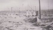
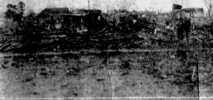
Wow that second pic from Dunlap is just total annihilation virtually. No surprise that 28 people died in that subdivision (presuming that’s Sunnyside Estates).
Navigation
Install the app
How to install the app on iOS
Follow along with the video below to see how to install our site as a web app on your home screen.
Note: This feature may not be available in some browsers.
More options
-
Welcome to TalkWeather! We see you lurking around TalkWeather! Take the extra step and join us today to view attachments, see less ads and maybe even join the discussion. CLICK TO JOIN TALKWEATHER
You are using an out of date browser. It may not display this or other websites correctly.
You should upgrade or use an alternative browser.
You should upgrade or use an alternative browser.
Significant Tornado Events
- Thread starter locomusic01
- Start date
I don't know if JR physically blocked Marshall from seeing certain areas of damage, but the E Wicker St EF5 candidate home was absolutely left out of his survey, and Marshall later said that he was not made aware of that particular house at the time of his survey of Vilonia.
Is there a source for this? Not doubting it one bit given everything that was occurred, but I’m curious.
MNTornadoGuy
Member
I have a rare book called "Black Sunday, April 30, 1967" which is about the 4/30/1967 Freeborn County MN tornadoes. It contains many great photographs from the outbreak and I'll post some of the most notable damage photographs.
Albert Lea F4:


(I'll post more pictures later)
Albert Lea F4:
(I'll post more pictures later)
MNTornadoGuy
Member
Hartland F4

Myrtle F4


Myrtle F4
Juliett Bravo Kilo
Member
I know I'm tooting my own horn here but see my previous postings on Palm Sunday 1965:I still don't get why all of the original 1965 Palm Sunday F5s were downgraded to F4s and yet tornadoes like the 1966 Belmond tornado were given an F5 rating.
Dunlap IN
View attachment 5530
View attachment 5531
Pittsfield-Strongsville OH
View attachment 5532
View attachment 5533
1. https://talkweather.com/threads/significant-tornado-events.1276/page-17#post-45658
2. https://talkweather.com/threads/significant-tornado-events.1276/page-17#post-45659
3. https://talkweather.com/threads/significant-tornado-events.1276/page-17#post-45629
Also, check out stormstalker's article on it, a ton of awesome damage photographs: https://stormstalker.wordpress.com/2013/01/05/1965-palm-sunday/
This chart shows wind speeds at the 500MB level on April 11, 1965. Note the jet stream located over the Midwest, with a maximum of 140kts over Illinois.

There were easily 5-6 F5s on that day, I really do wonder what the basis was for downgrading the handful that were previously awarded the F5 rating.
Juliett Bravo Kilo
Member
Poor quality, but this is some pretty scary footage of Hackleburg while it was in the Athens, Alabama area:
1.
1.
Last edited:
MNTornadoGuy
Member
Rochester, MN F5 Tornado – August 21, 1883 – Tornado Talk
One underrated tornado is the 1883 Rochester tornado. It was extremely violent, entire farms literally vanished with debris being spread for miles, people were killed in cellars, a large steel railroad bridge was crumpled, debris from swept away homes in Rochester was granulated and wind-rowed, intense ground scouring occurred at multiple locations along the tornado's path, trees were completely debarked, several cornfields were literally swept clean and gravel ballast was scoured out.Rochester, MN F5 Tornado – August 21, 1883 – Tornado Talk
www.tornadotalk.com
Yeah this was definitely one of the most violent tornadoes in Minnesota history, probably just second to Fergus Falls. One thing I learned about it recently, is that it’s path actually looped over itself in northern Rochester, similar to what happened in Moore 2013 near Moore Medical Center. The most extreme damage apparently occurred along this loop in the path.
MNTornadoGuy
Member
I believe there was more extreme damage in Dodge and Western Olmsted County based on damage reports though the damage in north Rochester was not far behind in intensity.Yeah this was definitely one of the most violent tornadoes in Minnesota history, probably just second to Fergus Falls. One thing I learned about it recently, is that it’s path actually looped over itself in northern Rochester, similar to what happened in Moore 2013 near Moore Medical Center. The most extreme damage apparently occurred along this loop in the path.
MNTornadoGuy
Member
The March 21, 1932 tornado outbreak is considered to be a Super Outbreak by some. What was probably the strongest tornado of the outbreak was the Cox-Union Grove AL tornado. Despite hitting rural areas, it killed 49 people including entire families. A mile-wide swath of trees was downed and homes were swept away. This photograph from Union Grove shows leveled trees next to the empty foundation of a home.

Juliett Bravo Kilo
Member
This outbreak, along with 1884 Enigma, 1908 and 1920 Dixie Outbreaks are some of my most favorite to research, it's a shame it's so hard to find clear and reliable damage photographs. 1932 and the three others I mentioned seem to have the problem many older outbreaks do, in which photographs of the most extreme damage and hardest hit areas are hard to come by. The Cox-Union Grove, AL tornado was the deadliest in Alabama's history until Hackleburg in 2011.The March 21, 1932 tornado outbreak is considered to be a Super Outbreak by some. What was probably the strongest tornado of the outbreak was the Cox-Union Grove AL tornado. Despite hitting rural areas, it killed 49 people including entire families. A mile-wide swath of trees was downed and homes were swept away. This photograph from Union Grove shows leveled trees next to the empty foundation of a home.
View attachment 5543
MNTornadoGuy
Member
Especially for the 1920 Dixie outbreak, there is barely any information available online about it and it seems to have been overshadowed by the 1920 Palm Sunday outbreak. One of the tornadoes from the 1920 Dixie outbreak seems to have been similar to the 2011 Hackleburg tornado.This outbreak, along with 1884 Enigma, 1908 and 1920 Dixie Outbreaks are some of my most favorite to research, it's a shame it's so hard to find clear and reliable damage photographs. 1932 and the three others I mentioned seem to have the problem many older outbreaks do, in which photographs of the most extreme damage and hardest hit areas are hard to come by. The Cox-Union Grove, AL tornado was the deadliest in Alabama's history until Hackleburg in 2011.
Marshal79344
Member
Damage I could find from some tornadoes in this outbreak
Northport, AL (EF4)
This was the first violent tornado of the event. It formed in a forested area, and was first noted near Ralph, AL, where significant tree damage occurred. The tornado continued to produce significant tree damage as it moved northeast, passing Fosters, AL before emerging into northwest Tuscaloosa. The tornado produced severe damage to homes, before intensifying further as it made a direct hit on the Tuscaloosa Country Club on the south side of the Warrior River, reaching EF4 intensity. The tornado then crossed the Warrior River, passed right through the Warrior Bridge (a large, black and strong bridge) that seemed to be unaffected. Just after the tornado emerged from the Warrior River into Northport, it impacted and absolutely annihilated the cotton gin factory. Numerous other homes nearby were leveled, and trees were denuded. An eyewitness in Northport described the tornado as a "ball of fire," likely indicating power flashes within the funnel. The tornado killed 37 in the Tuscaloosa-Northport area before the tornado dissipated after a short distance after it left Northport.
Aerial of the EF4 damage streak at the Warrior River (The Warrior River Bridge is seen at far left, the factory the devastated structure to it's right)

The obliterated Cotton Gin

Homes that were leveled in Northport


Columbiana, AL (EF4)
This narrow tornado first formed southwest of Columbiana, before moving right up into town. The narrow, fast-moving stovepipe funnel announced its arrival to the citizens of Columbiana with a large roar, eyewitnesses describing large timbers to have been flying around it. The tornado leveled several homes in the area, and destroyed the train station nearby too. The tornado continued snapping and uprooting trees for an unknown distance in the forests northeast of town before dissipating.
Remains of a home in Columbiana

The damaged Train Station \
\
Pulaski, TN (EF4)
This violent tornado was the second of four tornadoes born from the same supercell thunderstorm, and by far the strongest. It began southwest of town, snapping and uprooting hundreds of trees, growing quite large. It passed two miles west of town at full force, absolutely obliterating several homes just west of town. The tornado continued to produce significant damage as it moved northeast of town before dissipating.
The Devastated residential area west of town
It's disappointing to see how poorly documented this tornado outbreak was. I've asked some historical societies to see if they have any damage photos from this tornado outbreak. Several large and violent EF4 tornadoes occurred in the Sylacauga area , especially Chilton County. The photo MNTornadoGuy posted above is the only photo of damage I've seen from that area.
Northport, AL (EF4)
This was the first violent tornado of the event. It formed in a forested area, and was first noted near Ralph, AL, where significant tree damage occurred. The tornado continued to produce significant tree damage as it moved northeast, passing Fosters, AL before emerging into northwest Tuscaloosa. The tornado produced severe damage to homes, before intensifying further as it made a direct hit on the Tuscaloosa Country Club on the south side of the Warrior River, reaching EF4 intensity. The tornado then crossed the Warrior River, passed right through the Warrior Bridge (a large, black and strong bridge) that seemed to be unaffected. Just after the tornado emerged from the Warrior River into Northport, it impacted and absolutely annihilated the cotton gin factory. Numerous other homes nearby were leveled, and trees were denuded. An eyewitness in Northport described the tornado as a "ball of fire," likely indicating power flashes within the funnel. The tornado killed 37 in the Tuscaloosa-Northport area before the tornado dissipated after a short distance after it left Northport.
Aerial of the EF4 damage streak at the Warrior River (The Warrior River Bridge is seen at far left, the factory the devastated structure to it's right)
The obliterated Cotton Gin
Homes that were leveled in Northport
Columbiana, AL (EF4)
This narrow tornado first formed southwest of Columbiana, before moving right up into town. The narrow, fast-moving stovepipe funnel announced its arrival to the citizens of Columbiana with a large roar, eyewitnesses describing large timbers to have been flying around it. The tornado leveled several homes in the area, and destroyed the train station nearby too. The tornado continued snapping and uprooting trees for an unknown distance in the forests northeast of town before dissipating.
Remains of a home in Columbiana
The damaged Train Station
\Pulaski, TN (EF4)
This violent tornado was the second of four tornadoes born from the same supercell thunderstorm, and by far the strongest. It began southwest of town, snapping and uprooting hundreds of trees, growing quite large. It passed two miles west of town at full force, absolutely obliterating several homes just west of town. The tornado continued to produce significant damage as it moved northeast of town before dissipating.
The Devastated residential area west of town
It's disappointing to see how poorly documented this tornado outbreak was. I've asked some historical societies to see if they have any damage photos from this tornado outbreak. Several large and violent EF4 tornadoes occurred in the Sylacauga area , especially Chilton County. The photo MNTornadoGuy posted above is the only photo of damage I've seen from that area.
Attachments
Marshal79344
Member
Another damage photo appears to be in the Warrior River area from the tornado that hit Northport
MNTornadoGuy
Member
Southeast U.S. Severe Thunderstorm Climatology and 1932 Tornado Outbreak - ProQuest
Explore millions of resources from scholarly journals, books, newspapers, videos and more, on the ProQuest Platform.
 search.proquest.com
Juliett Bravo Kilo
Member
Some more information on 1932 Dixie Outbreak:Here is a detailed study of the 1932 Deep South tornado outbreak. I don't have a ProQuest account so I can't access it but if anyone here has a ProQuest account you should check it out.Southeast U.S. Severe Thunderstorm Climatology and 1932 Tornado Outbreak - ProQuest
Explore millions of resources from scholarly journals, books, newspapers, videos and more, on the ProQuest Platform.
1. https://www.alabamapioneers.com/193...sibly-300-people-in-alabama-on-march-21-1932/
2. https://apps.lib.ua.edu/blogs/coola...math-of-the-1932-tornado-outbreak-in-alabama/
3. NOAA's page on it: https://www.weather.gov/bmx/event_03211932
A lot of Dixie outbreaks of the past seem to have been rather poorly documented. Another thing to remember about these outbreaks is that fatality and injury rates are all likely hugely underestimated, due to how newspapers of the day often paid little, if any attention to the fates of African-American sharecroppers due to the racial bigotry and segregation of the era. Considering the significant Black population among the Deep South, (the "Black Belt" area) at the time, the fatality rates for many of the tornadoes among the 1932 and other Dixie outbreaks are probably double or triple the officially recorded numbers.
I'm a college student so I was able to access the PDF on the study of 1932, so I've posted it below:
Attachments
Juliett Bravo Kilo
Member
Are those trees debarked? Hard to tell with the B&W photography.Another damage photo appears to be in the Warrior River area from the tornado that hit NorthportView attachment 5556
MNTornadoGuy
Member
No they don't appear to beAre those trees debarked? Hard to tell with the B&W photography.
Juliett Bravo Kilo
Member
Especially for the 1920 Dixie outbreak, there is barely any information available online about it and it seems to have been overshadowed by the 1920 Palm Sunday outbreak. One of the tornadoes from the 1920 Dixie outbreak seems to have been similar to the 2011 Hackleburg tornado.
The MWR on the 1920 Dixie Outbreak in 2 PDF files, not sure if I already showed this to you, but oh well:
1. https://journals.ametsoc.org/view/j..._1920_48_203b_tiema_2_0_co_2.xml?tab_body=pdf
2. https://journals.ametsoc.org/view/j..._1920_48_205_ttoaia_2_0_co_2.xml?tab_body=pdf
Yeah, one of the tornadoes followed a path through Alabama that was virtually identical to 2011 Hackleburg, the only difference is it started a bit farther south in MS before crossing the state line. There was another tornado in MS that went through Neshoba County and had a path extremely similar to the 2011 Philadelphia tornado.
Juliett Bravo Kilo
Member
Addendum: that VLT tornado's path in MS went through Monroe County, which is where Smithville is located. An eyewitness description of the tornado describes it as looking like a giant cloud moving along the ground and a "fire" in front of the wind, perhaps the "fire" was actually "smoke" that was the big black wedge of the tornado beneath a low-hanging mesocyclone and clouds base? So yeah this thing was a clone in appearance to Hackleburg 2011 as well.The MWR on the 1920 Dixie Outbreak in 2 PDF files, not sure if I already showed this to you, but oh well:
1. https://journals.ametsoc.org/view/j..._1920_48_203b_tiema_2_0_co_2.xml?tab_body=pdf
2. https://journals.ametsoc.org/view/j..._1920_48_205_ttoaia_2_0_co_2.xml?tab_body=pdf
Yeah, one of the tornadoes followed a path through Alabama that was virtually identical to 2011 Hackleburg, the only difference is it started a bit farther south in MS before crossing the state line. There was another tornado in MS that went through Neshoba County and had a path extremely similar to the 2011 Philadelphia tornado.