Here's a summary of some buildings in the Vilonia area that did not receive a DAT point/DI assigned to them if they were surveyed.
View attachment 5485
This home on Beryl Rd immediately north of several that were given EF4 ratings on Cody Lane, does not appear to have a DI, with extensive scouring present both upstream and downstream of the damage.
View attachment 5486
Neither of these homes (the ones from the pictures above) were given DIs on S Coker Rd. I believe at least one of them, on the upper right, was constructed to code with anchor bolts/etc per account of the owner (Lee Lentz). Extensive scouring and wind rowing present both upstream and downstream of this location.
View attachment 5487
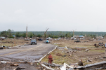
Not a single home that was swept away in this neighbourhood on Cemetery Street south of downtown was given a DI, regardless of construction standards. Like just lol.
View attachment 5488
This building in downtown on the north side of the highway that was probably not greatly constructed was completely wiped away (I believe it was some kind of restaurant), but nonetheless had no DI.
View attachment 5489
Finally, here is the home on E Wicker St. that should've been given an EF5 rating, but gymnastics were performed to avoid doing so. Not only that, the house directly across the street on the south side that was swept away has no DI.
Done using the 4/30/2014 overhead shots from Google Earth with the DAT KML file overlaid to give an indication of where DIs were located and where they were not. It is of note that Tim Marshall's subsequent assessment did not include
any of these areas in its information:
https://www.researchgate.net/public...vey_of_the_Mayflower-Vilonia_Arkansas_Tornado
View attachment 5490