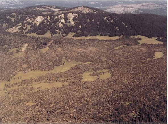
So, this is pretty wild. On June 18, 1975, a family of eight tornadoes struck roughly between the towns of Bartley and Arnold in Central Nebraska (called the Gothenburg tornado family in reference to the biggest town in the area). Many of the paths were separated by relatively short distances such that it was first reported as a single tornado with a 90-mile length. Five of the tornadoes were rated F3 and one, near Arnold, was rated F4. There were reports of multiple tornadoes on the ground at once, satellite tornadoes, horizontal vortices, etc. At least one of the tornadoes looked rather visually imposing (this was near Peterson, NE):
View attachment 1833
Anyhow, that's not the really interesting bit. No, what makes this event most notable is that it did some distinctly Philadelphia, MS-esque things. To wit:
View attachment 1836
View attachment 1837
View attachment 1838
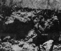
Bit hard to make it out, but here's what you're looking at. The tornado near Moorefield, NE created a "hole" that measured about 10 ft by 6.5 ft and up to 18.5 inches deep. It also created a "crack" that appears to be about the same length as the hole but much narrower. The sides are sharp and steep in some places and more gradual in others. There are a few broken chunks of sod downstream from these features, but otherwise not much else. There's a mangled windmill barely visible in the background of the first picture, but it apparently wasn't associated with these features and there don't seem to be any other debris/missile-related causes.
Greg Forbes studied the event and postulated that some combination of lightning + suction vortex could've caused it, but he was operating under the assumption that tornadic winds alone couldn't do the job. Of course, we've seen since then that tornadoes can indeed do this sort of thing. He took an interesting approach of using soil shear-strength tests to estimate that velocities in the range of 246-291 mph would be required for wind alone. His objection was that the wind speed at the surface must necessarily be zero given the boundary layer physics involved. That stuff's above my pay grade, but my sense is that it's more a theoretical principle than a practical one - given the turbulence of wind flows in tornadoes, the updrafts and downdrafts, variations in surface roughness, debris loading, etc. it seems clear to me that it doesn't hold up in the real world.
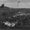
Oh, the later F4 tornado near Arnold also did this:
View attachment 1839
View attachment 1840
The "O" in the first photo represents the approximate starting location of a pair of combines, one of which weighed 18,500 lbs and the other slightly less. The heavier combine was tossed a tenth of a mile to the location marked "L" and the lighter one, pictured in the second photo, came to rest 0.16 miles away in the spot marked "B." Grain bins and other assorted bits of large debris were lofted pretty substantial distances as well. Trees in the direct path of this tornado at its most intense were also reportedly stripped bare, some of them snapped off just a few feet above ground level.
All in all, another rather impressive (and probably underrated) event that's gone mostly unnoticed because of the remote Nebraska location.