
This link deserves some serious attention, some wonderful photos of big-time tornadoes there. Herbert Stein was one of the great chasers (and also was a member of several research teams). RIP.
Navigation
Install the app
How to install the app on iOS
Follow along with the video below to see how to install our site as a web app on your home screen.
Note: This feature may not be available in some browsers.
More options
-
Welcome to TalkWeather! We see you lurking around TalkWeather! Take the extra step and join us today to view attachments, see less ads and maybe even join the discussion. CLICK TO JOIN TALKWEATHER
You are using an out of date browser. It may not display this or other websites correctly.
You should upgrade or use an alternative browser.
You should upgrade or use an alternative browser.
Significant Tornado Events
- Thread starter locomusic01
- Start date
Juliett Bravo Kilo
Member
This footage of Niles/Wheatland always blows me away:
According to Grazulis that this was the first F5 tornado to be caught on videotape (as opposed to just old film roll cameras). I'm pretty sure this is also the first audio of an F5 tornado as well. Even more impressive is that these two firsts are of an F5 in Pennsylvania (the only F5 in Pennsylvania state history, I might add) as opposed to being in a place like Kansas, Oklahoma, or the Deep South, where violent tornadoes like this are more commonly expected.
According to Grazulis that this was the first F5 tornado to be caught on videotape (as opposed to just old film roll cameras). I'm pretty sure this is also the first audio of an F5 tornado as well. Even more impressive is that these two firsts are of an F5 in Pennsylvania (the only F5 in Pennsylvania state history, I might add) as opposed to being in a place like Kansas, Oklahoma, or the Deep South, where violent tornadoes like this are more commonly expected.
Last edited:
Peter Griffin
Member
Yeah that is some incredible motion on that towards the end of the video. Beastly.This footage of Niles/Wheatland always blows me away:
According to Grazulis that this was the first F5 tornado to be caught on videotape (as opposed to just old film roll cameras). I'm pretty sure this is also the first audio of an F5 tornado as well. Even more impressive is that these two firsts are of an F5 in Pennsylvania (the only F5 in Pennsylvania state history, I might add) as opposed to being in a place like Kansas, Oklahoma, or the Deep South, where violent tornadoes like this are more commonly expected.
Sent from my SM-N975U using Tapatalk
Equus
Member
Whoa this thread took off this week. Awesome. Time to read.
Good news - that's another thread I archived, buuuut only through mid 2014.
Guin took forever to find decent damage photos of- i think it took until that video on that page was discovered. That was way back on the old TW in the "strongest Tornado Ever" thread. That was a good thread, wish it could've been archived.
Good news - that's another thread I archived, buuuut only through mid 2014.
Juliett Bravo Kilo
Member
The Moshannon State Forest tornado of 1985 generated tremors that were picked up by nearby seismographs. I do wonder if most violent tornadoes have the power to generate short-term earthquake-like effects on soil but it isn't very well-documented as tornadoes tend to occur in places not known for earthquakes. Powerful earthquakes can generate liquefaction of soil and that's how you can wind up with stuff like thisI'm no expert but did study soils a bit back in the 80s in forestry. It's incredibly complex and can vary dramatically over a distance of just a few feet. You also must think of the layering at depth and, of course, vegetation and the various kinds of root systems.
That said, I was fascinated by the straight lines in those pictures of gouged-out areas after a tornado passed. That kind of looks like faulting in a solid area that's under stress.
One was even sort of rectangular!
Ordinary soil doesn't do that. Most soil boundaries are irregular in shape.
Anyway, moist soil should be more cohesive than dry stuff, and less like to get picked up. That's true of normal erosion. As for the beasts under discussion . . . ?
Could these rare gouges be places where there is a hard, but shallow "pan" of some sort, with the tornado approaching at such an angle that its seismic effects stress this more solid area so that some of it fractures and gets pulled up?

after an earthquake. Perhaps tornadoes can do stuff like that (albeit at a much smaller level) to soil that allows for easier ground scouring? Interesting thought you have there. I believe Tim Samaras was working on a project on tornado-induced seismic waves but it never came to pass due to his passing away in 2013.
Last edited:
Juliett Bravo Kilo
Member
I remember this tornado as being one of the few that earned the label 'maxi-tornado' by Grazulis.Yeah that is some incredible motion on that towards the end of the video. Beastly.
Sent from my SM-N975U using Tapatalk
Last edited:
Juliett Bravo Kilo
Member
So this is interesting, he is working on the updated version of Significant Tornadoes.
 www.tornadoproject.com
The Tornado Project
The Tornado Project is a small company that researches, compiles and makes tornado information available to tornado and severe weather enthusiasts, the public, the meteorological community and emergency management officials in the form of tornado videos, tornado books, and tornado posters.
www.tornadoproject.com
Equus
Member
Last I heard Feb 2022 was the expected date for new sigtor to be ready for ordering, I really hope that stays on schedule cuz I'm definitely eager to order it.
Juliett Bravo Kilo
Member
The best collection of damage photos of the San Justo tornado I've been able to find. Yeah, this thing was definitely an F5, and this is probably the most violent tornado damage I've seen outside of the United States.
This article is interesting when read in English translation, as apparently this was the only F5 tornado not just in South America but the entire southern hemisphere. Not sure of the accuracy of that, but interesting nonetheless:
Interesting thing on Spanish wikipedia. The first is Spanish translation of their article on "tornado corridors". Apparently South America has its own tornado alley. The second is an English translation of their article on the 1973 San Justo tornado:
1. https://translate.google.com/transl....org/wiki/Pasillo_de_los_Tornados&prev=search
2. https://translate.google.com/transl...wiki/Tornado_de_San_Justo_en_1973&prev=search
This is apparently a pic of it. No clue what the 3 circled objects in the air are, but my guess is automobiles.
Juliett Bravo Kilo
Member
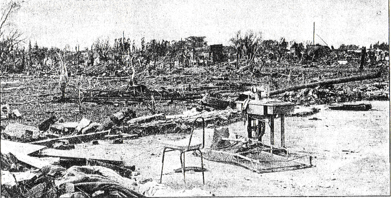
Some photographs of damage done by the Moshannon State Forest tornado
:


The path of this thing is still visible decades later due to the immense deforestation it did. Pretty incredible:

An article on it's 30th anniversary. Seems like it did most of its damage to structures at the very beginning of its path. I am curious as to what was the DI that allowed for the F4 rating (aside from massive swaths of tree damage):

 gantdaily.com
:
The path of this thing is still visible decades later due to the immense deforestation it did. Pretty incredible:
An article on it's 30th anniversary. Seems like it did most of its damage to structures at the very beginning of its path. I am curious as to what was the DI that allowed for the F4 rating (aside from massive swaths of tree damage):
Survivors Remember Parker Dam Tornado 30 Years Later
(Photo provided by Ken Hunt) Surrounded by hundreds of yards of uprooted and snapped off trees,
Shakespeare2016
Member
No question about it.Good lord those vehicles from Andover. Certainly supports the visual intensity seen in Duke Evans' video from the golf club.
Shakespeare2016
Member
That is some pretty violent tree damage.Some photographs of damage done by the Moshannon State Forest tornado
:View attachment 3217
View attachment 3218
View attachment 3219
View attachment 3220
The path of this thing is still visible decades later due to the immense deforestation it did. Pretty incredible:
View attachment 3224
An article on it's 30th anniversary. Seems like it did most of its damage to structures at the very beginning of its path. I am curious as to what was the DI that allowed for the F4 rating (aside from massive swaths of tree damage):
Survivors Remember Parker Dam Tornado 30 Years Later
(Photo provided by Ken Hunt) Surrounded by hundreds of yards of uprooted and snapped off trees,
Shakespeare2016
Member
Now the Hesston, Kansas tornado I believe deserved an F5 rating the Gossell tornado probably did not. If you never watched the Hesston tornado on YouTube you probably should. It reminds of the Elie, MB on June 22, 2007 but wider when doing F5 damage.Honestly I have a few questions to raise about all of the officially-rated F5 tornadoes in 1990. Hesston was borderline, since most of the houses swept away were not especially well-anchored, with only a couple being very well-built. I agree completely that Goessel was massively overrated.
Plainfield was an interesting case because almost all of the damage to buildings, vehicles, other structures, etc. was intense, but not exceptional...while at the same time, the crop scouring in the cornfields near the start of the path was extremely impressive, with apparently only roots left behind. It's another one of those cases where the rating really depends on whether you include vegetation damage as a DI. I haven't seen any photos of structural damage worse than low-end F4, but crop scouring that intense absolutely justifies an F5 rating imho.
I still am totally convinced that the strongest tornado of the year was the Pecos County tornado on 6/1, with the Trenton/Culbertson, NE tornado (6/15) being a close runner-up.
Shakespeare2016
Member
This footage of Niles/Wheatland always blows me away:
According to Grazulis that this was the first F5 tornado to be caught on videotape (as opposed to just old film roll cameras). I'm pretty sure this is also the first audio of an F5 tornado as well. Even more impressive is that these two firsts are of an F5 in Pennsylvania (the only F5 in Pennsylvania state history, I might add) as opposed to being in a place like Kansas, Oklahoma, or the Deep South, where violent tornadoes like this are more commonly expected.
That is an extremely violent tornado. I like how the guy in the vid says that's paper. That is a lot more than paper. I never knew the violence of this tornado until recently.
Juliett Bravo Kilo
Member
I'd love to get more aerial views of it, especially when the tornado went through valleys and ridges and climbed mountains around 2,000 feet or so high. I think it may have toppled some fire towers and mangled them violently, but have yet to find photos of it. What's interesting about this thing is that it had a width of 2.25 miles and a path length that was nearly 70 miles long, virtually identical to the violent EF4 that impacted Bassfield and Pachuta, MS last month. That thing also left a wide scar of deforestation visible from satellite and uprooted tens of thousands (if not millions) of trees as well. It was also 2.25 miles wide at its peak.That is some pretty violent tree damage.
Powerful earthquakes can generate liquefaction of soil and that's how you can wind up with stuff like this
View attachment 3215
after an earthquake. Perhaps tornadoes can do stuff like that (albeit at a much smaller level) to soil that allows for easier ground scouring? Interesting thought you have there. I believe Tim Samaras was working on a project on tornado-induced seismic waves but it never came to pass due to his passing away in 2013.
Wow! Interesting how that effect cut across plowed rows of dirt. I suspect that is because the movement originated at depth.
Massive tornadoes probably do cause seismic waves (and infrasound and all kinds of interesting effects), but these would only affect the top layers of the soil.
Perhaps human alteration of the landscape is behind those very rare tornado gouge effects. If not, it's hard to explain.
By the way, someone called them "Philadelphia style." Does anyone know what that means?
In geology there is sometimes a shear effect when two formations move in different directions; it creates what's called a "pull-apart" basin that sort of resembles those gouges. This can happen either as one large one (as shown) or, as in some of the other pictures, a linear row of separate and very small basins that follow the line where the two differently moving formations meet (in geology, a fault line -- there probably isn't an equivalent for it in loose soil, and even hardpan could be called "loose" compared to rock).
Certainly there is plenty of shear associated with a massive tornado on the ground, but whether or how that could be transmitted to the ground, I have no idea. And pull-apart basins might only happen in rock, not comparatively loose dirt. (Also, the piece affected moves down, not up, but if there is an opening for wind to enter while this is going on, and with a huge vortex there, well, maybe...it's interesting to think about, anyway.)
If they could figure out an instrument-free way to link ground-scouring processes to tornado intensity, that would really help the problem that many people have mentioned here: determining tornado intensity when there was no human structure around for the storm to damage.
But there are SO many variables.
Juliett Bravo Kilo
Member
"Philadelphia style" is a reference to this:Wow! Interesting how that effect cut across plowed rows of dirt. I suspect that is because the movement originated at depth.
Massive tornadoes probably do cause seismic waves (and infrasound and all kinds of interesting effects), but these would only affect the top layers of the soil.
Perhaps human alteration of the landscape is behind those very rare tornado gouge effects. If not, it's hard to explain.
By the way, someone called them "Philadelphia style." Does anyone know what that means?
In geology there is sometimes a shear effect when two formations move in different directions; it creates what's called a "pull-apart" basin that sort of resembles those gouges. This can happen either as one large one (as shown) or, as in some of the other pictures, a linear row of separate and very small basins that follow the line where the two differently moving formations meet (in geology, a fault line -- there probably isn't an equivalent for it in loose soil, and even hardpan could be called "loose" compared to rock).
Certainly there is plenty of shear associated with a massive tornado on the ground, but whether or how that could be transmitted to the ground, I have no idea. And pull-apart basins might only happen in rock, not comparatively loose dirt. (Also, the piece affected moves down, not up, but if there is an opening for wind to enter while this is going on, and with a huge vortex there, well, maybe...it's interesting to think about, anyway.)
If they could figure out an instrument-free way to link ground-scouring processes to tornado intensity, that would really help the problem that many people have mentioned here: determining tornado intensity when there was no human structure around for the storm to damage.
But there are SO many variables.
This tornado struck areas near Philadelphia, MS during the April 27, 2011 Super Outbreak. These trenches were up to 3 feet deep in places.
Last edited:
Juliett Bravo Kilo
Member
What's interesting is that Niles/Wheatland didn't do much debarking of trees in its path. Uprooted many yes, but not much in the way of debarking. Perhaps it's a tree species thing?That is some pretty violent tree damage.
That last photo is a fake. It's a digitally aged photo of the 2013 Shawnee, OK EF4. There's also photo of the 2003 O'Neill, NE tornado being passed off as the San Justo tornado, which there are no actual photos of. IDK why people feel the need to fabricate pieces of tornado history. In any case, it was an extremely violent tornado that scoured the grass to bare soil in some area, and caused well-built homes to essentially disappear according to some reports. Here is one of the homes that was swept away in San Justo. I used to have a "before" picture of it but now I can only find the "after" pic. But anyway, this was a large, sturdy concrete/masonry house.The best collection of damage photos of the San Justo tornado I've been able to find. Yeah, this thing was definitely an F5, and this is probably the most violent tornado damage I've seen outside of the United States.
This article is interesting when read in English translation, as apparently this was the only F5 tornado not just in South America but the entire southern hemisphere. Not sure of the accuracy of that, but interesting nonetheless:
Interesting thing on Spanish wikipedia. The first is Spanish translation of their article on "tornado corridors". Apparently South America has its own tornado alley. The second is an English translation of their article on the 1973 San Justo tornado:
1. https://translate.google.com/transl....org/wiki/Pasillo_de_los_Tornados&prev=search
2. https://translate.google.com/transl...wiki/Tornado_de_San_Justo_en_1973&prev=search
This is apparently a pic of it. No clue what the 3 circled objects in the air are, but my guess is automobiles.
View attachment 3216
Last edited:
From what I understand, this was one of those rare tree-damage based F/EF4s. They seem to be a little more common as of late though.Some photographs of damage done by the Moshannon State Forest tornado
:View attachment 3217
View attachment 3218
View attachment 3219
View attachment 3220
The path of this thing is still visible decades later due to the immense deforestation it did. Pretty incredible:
View attachment 3224
An article on it's 30th anniversary. Seems like it did most of its damage to structures at the very beginning of its path. I am curious as to what was the DI that allowed for the F4 rating (aside from massive swaths of tree damage):
Survivors Remember Parker Dam Tornado 30 Years Later
(Photo provided by Ken Hunt) Surrounded by hundreds of yards of uprooted and snapped off trees,