• Welcome to TalkWeather!
    We see you lurking around TalkWeather! Take the extra step and join us today to view attachments, see less ads and maybe even join the discussion.
    CLICK TO JOIN TALKWEATHER

Significant Tornado Events

The damage west of Hackleburg rated EF5 was questionable, and I think Marshall’s disagreement was definitely justifiable. NWS Huntsville rated this home in particular EF5, but it was constructed on a CMU foundation with little to no anchoring at all. View attachment 37366View attachment 37367
A lot of ef5 DIs from Hackleburg wouldn’t even be assigned ef4 today, and rightfully so.

I’m not sure what went on with that survey, but it’s pretty bemusing to see so many unreinforced/unanchored CMU foundations get rated ef5 and see the shrubs around the foundation completely unscathed and the ground unscoured.

Obviously though their were a few structures that were genuine ef5 DIs and I believe Hackleburg was the second strongest tornado that day.
 
Man, something about Texas tornadoes..... big, monstrous things all out by themselves on the lonesome prairies but still seeming like they're searching for something to strike
Yeah, really. Just thinking about all those tornadoes out in west Texas, monsters, beasts, yet no one will ever know of what power they truly possessed.
 
  • Like
Reactions: AJS
Agreed, having said that, some of the Parkersburg, Joplin, and Greensburg EF5 dis Marshal has written about do also seem questionable to me. Not doubting the overall rating though. Also I wish better views of the Oak Grove home existed.
This I also agree with. I know he does factor in contextual evidence heavily, which surveyors should do, but yeah a few examples he’s rated EF5 are kind of iffy. This home in particular shown as an example of EF5 damage from Parkersburg stands out the most to me. The toilet is still there holding strong along with the subfloor and other bits of sizeable debris.
541C52A1-71AF-4F83-8226-24A29AD50E14.jpeg

Here’s some other ground shots of EF5 rated homes by Marshall within Parkersburg as well.
DA168F4B-6306-4E26-A191-A19EDA6B81AE.jpegA078CD29-9323-41ED-9320-5B3C9A52A5A2.jpegED8BB719-8AC1-40C5-94EB-2844A1A096AB.jpegF8F2924A-6AFF-49CC-BA52-6D57301EBAA4.jpeg
These ones I can see where EF5 could be justified, however I think with how bonkers the criteria is in the present day they could get slapped with an EF4 rating (or even EF3 depending on the office). With Greensburg there were a few homes I was kind of surprised they were assigned EF5, however there were also several homes that I think could’ve been upgraded. Like you said, the ratings are appropriate, but some of the instances of damage assigned EF5 are interesting.
 
Just discovered this while researching Mayfield. Everyone knows the University of Kentucky was hit, but the pictures that were circulating were of a structure that was never anchored properly into its foundation with rebar. However, a second building was hit, and this one was built properly with reinforced concrete and CMU.

Notice all the rebar sticking out of the ground? No anchoring issues here.

1743138464154.jpeg
1743138525109.jpeg
1743138539873.jpeg
1743138668963.jpeg


Not only that, but it was also anchored with steel embedded plates

1743138647663.jpeg


Here's mangled concrete where all of it was yanked out of the ground.

1743138865577.jpeg


The building was absolutely obliterated

1743192502438.jpeg1743192515241.jpeg
1743192605921.jpeg1743192644665.jpeg

The maximum DI for institutional buildings (which includes universities) is "significant damage to building envelope", and it has an associated expected wind speed of 210mph, with an upper bound of 268 mph. So, why wasn't it rated EF5? Well, the building was reclassified as an "elementary school", which has much lower expected wind speeds, and it was given a final rating of EF3.
 

Attachments

  • 1743192460185.jpeg
    1743192460185.jpeg
    697.2 KB · Views: 0
This I also agree with. I know he does factor in contextual evidence heavily, which surveyors should do, but yeah a few examples he’s rated EF5 are kind of iffy. This home in particular shown as an example of EF5 damage from Parkersburg stands out the most to me. The toilet is still there holding strong along with the subfloor and other bits of sizeable debris.
View attachment 37468

Here’s some other ground shots of EF5 rated homes by Marshall within Parkersburg as well.
View attachment 37469View attachment 37470View attachment 37471View attachment 37472
These ones I can see where EF5 could be justified, however I think with how bonkers the criteria is in the present day they could get slapped with an EF4 rating (or even EF3 depending on the office). With Greensburg there were a few homes I was kind of surprised they were assigned EF5, however there were also several homes that I think could’ve been upgraded. Like you said, the ratings are appropriate, but some of the instances of damage assigned EF5 are interesting.
Oh yeah, I hope your project on Greensburg is still going strong. Do you have any photos of the homes that were not given EF5 but are EF5 candidates? That is quite interesting to me.
 
Cold waters of the lake (especially in early spring coming out of a cold winter when lake temperatures are below average) tend to create a cool easterly lake breeze that restricts how far north warm fronts can push. It also tends to make them rather sharp (tight temperature/moisture gradient) right over the Chicago metro. Thus a SW-NE moving storm approaching the front may briefly experience enhanced low-level shear, but will quickly cross the boundary and become undercut in cool air.

Local chaser/meteorologist Andrew Pritchard had a good write-up in which he mentioned how sharp warm fronts are less favorable for significant tornado events in his recent blog about the March 19 setup in Illinois.

It is interesting how many nuances there must be with the lake effect. Remember the April 3 1956 outbreak, which not only had an F5 not far east of Lake Michigan, but also had an F4 immediately before it on the beach of Lake Michigan. I believe there was another F4 or 3 near Traverse City too, way up north.
 
Just discovered this while researching Mayfield. Everyone knows the University of Kentucky was hit, but the pictures that were circulating were of a structure that was never anchored properly into its foundation with rebar. However, a second building was hit, and this one was built properly with reinforced concrete and CMU.

Notice all the rebar sticking out of the ground? No anchoring issues here.

1743138464154.jpeg
1743138525109.jpeg
1743138539873.jpeg
1743138668963.jpeg


Not only that, but it was also anchored with steel embedded plates

1743138647663.jpeg


Here's mangled concrete where all of it was yanked out of the ground.

1743138865577.jpeg


The building was absolutely obliterated

View attachment 37555View attachment 37556
View attachment 37557View attachment 37558

The maximum DI for institutional buildings (which includes universities) is "significant damage to building envelope", and it has an associated expected wind speed of 210mph, with an upper bound of 268 mph. So, why wasn't it rated EF5? Well, the building was reclassified as an "elementary school", which has much lower expected wind speeds, and it was given a final rating of EF3.
Nope. This is literally just an annex to the same UK facility. If you don’t know what that is, look it up. It was a grain research lab, and it was afflicted by the same lack of rebar anchoring as the rest of the facility. NWS Paducah specifically went over this in a live presentation, and I did a bit of a deep dive into this specific structure after the event. It’s not a separate building, and the construction issues are not up for debate. The photos you posted are simply the far left side of the complex, visible below. It’s the same building with the same rebar connection problems, bottom line:
IMG_9043.jpeg

You are continuing to post misinformation based on assumptions, and you are continuing to try to make calls despite not having the needed information or knowledge. If you keep it up, you WILL wear out your welcome here, and based on a scan of the forum today, you are already in the process of doing that. I’m not trying to be a jerk or gatekeep, but I am trying to give you a fair warning.

If you don’t improve the quality of your posts, you simply aren’t going to have a good time here.
 
Last edited:
Oh yeah, I hope your project on Greensburg is still going strong. Do you have any photos of the homes that were not given EF5 but are EF5 candidates? That is quite interesting to me.
It is! Few more people I’d like to contact but overall satisfied with the progress I’ve made, especially with research. As for the photos, yes I do have images of them. Tim Marshall was gracious enough to send me photos of virtually every home damaged within town, other than a select few.

Also your earlier post on this page reminded me, speaking of Greensburg, Parkersburg and Joplin, I think those 3 tornadoes are all extremely comparable intensity-wise. Obviously they’re all unique in their own ways, but overall IMO it’s not a hot take to say all 3 of them reached similar intensities. Like @TH2002 said, it’s futile to determine definitively which tornado was stronger, and that goes for (almost) every EF5-rated tornado.
 
Last edited:
@Western_KS_Wx You have done some absolutely incredible research and dug up some wonderful info on the Greensburg, KS tornado and I was wondering if you happen to have some images of the Trousdale, KS tornado and the damage it caused! No worries if not.
I appreciate it! Yes I do, there are very little photos out there of the tornado itself due to how enormous and shrouded it was but I do have multiple damage photos. Earlier I said I’m still waiting to contact some people, that’s mainly because of Trousdale and Hopewell. I’ve had several people message me and say they have photo albums but only a few have actually turned up anything unfortunately. Anyways, here’s an earlier post I made showing some very obscure images I uncovered showing the Trousdale tornado as it formed and exploded in size.
I recently uncovered an old weather forum that had a thread with a large number of chasers discussing the Greensburg tornado. Using the Wayback Machine, I was able to archive the posts and found a website one of the members posted and discovered some pretty neat stuff.

The member was a chaser who came up on the Greensburg supercell from the south on Highway-183 around 10:00 PM or so, arriving a little late to the party but just in time to capture what I believe is the only images of the supercell cycling before producing the monstrous Trousdale tornado. There was probably 200+ photos in order between the time the Greensburg tornado occluded and when the Trousdale tornado was in progress. Here’s a select few of the better images I picked out from the gallery.

This screengrab shows the Greensburg tornado occluding and moving fully west as it crosses Highway-183 for a second time. This is as the tornado was executing a loop before it eventually stalled out and dissipated. Based on radar data, this image was taken around 10:02-10:03 PM.
View attachment 29868

These images show what I believe is the decaying remnants of the Greensburg mesocyclone becoming involved in the new handoff northeast of town, along with a huge RFD surge racing east toward the developing circulation. The second photo is the rapidly intensifying mesocyclone that goes on to produce the Trousdale tornado. Several satellite tornadoes and smaller vortices formed in the moments prior to the Trousdale tornado touching down.
View attachment 29869View attachment 29870

Finally, these images captured the genesis of the Trousdale tornado, and showcase just how rapidly the circulation became very large within moments of touching down. Probably going to try and enhance some of these to fully grasp what’s going on here, but the second photo shows the tornado before it wedged-out, followed by a radar image around the same time the photo was taken.
View attachment 29871
View attachment 29872View attachment 29873

And here’s the Trousdale tornado as it expands to 2 miles in width while also being accompanied by a satellite tornado. Based on Demko and Farrar’s video and these images, the Trousdale tornado had at least 3 satellite tornadoes that appear to have gone undocumented.
View attachment 29874
 
  • Like
Reactions: AJS
I was just digging through the archived chase reports thread on Stormtrack for the Greensburg event (trying to see if that's what @Western_KS_Wx was referencing in the post quoted above). I'd forgotten that the late Joel Taylor, who appeared on Storm Chasers, used to post there. I found his comment here quite amusing given everything that has transpired in the years since. "I never should've let Reed drive."

 
I appreciate it! Yes I do, there are very little photos out there of the tornado itself due to how enormous and shrouded it was but I do have multiple damage photos. Earlier I said I’m still waiting to contact some people, that’s mainly because of Trousdale and Hopewell. I’ve had several people message me and say they have photo albums but only a few have actually turned up anything unfortunately. Anyways, here’s an earlier post I made showing some very obscure images I uncovered showing the Trousdale tornado as it formed and exploded in size.
I may be sounding a bit weather weenie here lol, but I do have a funny feeling it’s possible that the actual size of Trousdale could have been larger than its documented weight.

( I am not doubting the official weight btw. )

And it definitely reminds me of some other very large/wide wedges that formed and rapidly expanded in size. Seems to have been almost a nighttime Bassfield/Soso tornado given it formed and grew so rapidly and was a very violent tornado.
 
Xenia deserved its rating for the small swath around/west of the US-35 bypass IMO. It had all the classic hallmarks - debris granulation, intense wind rowing, some pretty intense vehicle & vegetation damage, a bunch of homes swept cleanly away (even if most weren't built to modern EF5 standards), a pretty high concentration of fatalities in the F5 area, etc.

At the same time, I understand why it's gotten kinda downplayed in recent years because it was initially hyped up as at least the most violent tornado of the outbreak, if not one of the most violent ever, which it definitely wasn't. It just received more attention and hype than it deserved because it hit a large-ish city and was highly photographed and whatnot.

Ik im super very late to this sorry but do you happen to have any photos from this area or anywhere in Xenia that shows severe vegetation damage?
 
  • Like
Reactions: AJS
The 1990 Bakersfield Valley/McCamey TX tornado intrigues me a lot; so Ive done some digging.

The Iraan News held a GOLDMINE of information on this elusive event:
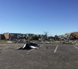
They reported that at least 60 vehicles were damaged by the tornado, with the track of the F4 being: "For the first ten minutes, the funnel appeared to have hopped around but then for an hour, a constant path could be traced".
Some notes of the damage are mind blowing; with county personnel having to bury the "staggering" number of dead farm animals; to "The Bakersfield Co-Op and gin were demolished. Irrigation ditches were shattered and vegetation was stripped away leaving miles of bare ground.". Somethings of note consist of Oil wells being slug or tipped, spilling oil down the hillsides, painting them black; overturned pumpjacks littering the terrain; a mass of wires being tumbled and pushed into a nearly rounded ball; an anhydrous ammonia tank being rolled/shot far from the "co-op"; asphalt being stripped from the roads multiple times; a cement irrigation ditch being pulled away from it's walls, the cement thrown; to over 366 electrical polls being destroyed. A few communities went without water due to the tornado's damage. I have genuine reason to think this tornado was stronger than even Loyal Valley 1999.
The claim this tornado "didn't loft debris" is entirely false; with The Big Lake Wildcat reporting a check being found in Reagan County, which is "45-50" miles away from the tornado site. Multiple ranchers spoke of loosing every single one of their ranch animals; which photos depict an awful scene of dead farm animals just everywhere. I must note I will be trying to get my hands on a book that details some of the survey of the F4, although it will take me time; the book is: "The Tornado: Its Structure, Dynamics, Prediction, and Hazards". The book isnt cheap, but this tornado is utterly historic; my research will be continuing on it.

(Files attached are the Iraan News pages!!)
The Big Lake Wildcat 6-7 McCamey.PNGThe Boerne Star 6-20 McCamey.PNG
 

Attachments

Back
Top