Ivanthetornadoenthusiast
Member


New Tionesta 1985 photos
Follow along with the video below to see how to install our site as a web app on your home screen.
Note: This feature may not be available in some browsers.


I wonder how long Michigan's grace period will last. I imagine that someday, either due to a pattern change or as a complete fluke event, there will be more violent tornadoes.
Agreed that it does feel like a case of 155-165 EF3 today given the modern application of the scale for better or worse

I think it would look similar to March 2, 2012 as well, except with the high risk brought down into MS and AL with one or two 45% contours for the areas with the highest confidence in a violent tornado threat, one in the northern mode and another in the southern mode.Not completely modern since it was before the five-category system, but I think it would probably look similar to March 2, 2012. To be perfectly accurate, maybe the high risk area would be extended to encompass northern Alabama, and perhaps a 45% hatched tornado contour where the really dense concentration of violent tornadoes took place over the Ohio River region.
Does anybody have any video (when it was in Jefferson county) of the April 27th 2011 tornado that crossed through Tuscaloosa into northern Jefferson county? I always see the footage of it in Tuscaloosa but not much in fultondale and surround areas.
I found this incredible clip just a little bit ago from fultondale.
I am confident in saying that Andover, Bridge Creek/Moore 1999, Jarrell TX, Niles/Wheatland, and Brandenburg would still be rated EF5 today.I don't know if this has been asked, but are there any F-5 tornadoes pre-2007 that would be rated EF-5 today? Like I know there are a few like Niles, OH-Wheatland, PA and Bridge Creek-Moore, OK. But what would be some other examples?
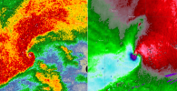
I would actually say the velocity signature on the Western Kentucky tornado when it was in Bremen. I have never seen such a tightly compact velocity signature like I did with the velocity signature in Bremen.I have a question: what would y’all regard as the most violent looking tornado signature on radar that you’ve seen? For me personally, it was the 2021 Western Kentucky tornado as it was impacting Mayfield. Seeing a scatter spike coming off of a massive debris ball is something I don’t recall seeing before or since.

The most violent personally I witnessed while covering events was this one. Same day as rolling fork. I didn't witness or stay up for the Mayfield event but I wouldve probably ranked that one 1st.I have a question: what would y’all regard as the most violent looking tornado signature on radar that you’ve seen? For me personally, it was the 2021 Western Kentucky tornado as it was impacting Mayfield. Seeing a scatter spike coming off of a massive debris ball is something I don’t recall seeing before or since.
I think it would look similar to March 2, 2012 as well, except with the high risk brought down into MS and AL with one or two 45% contours for the areas with the highest confidence in a violent tornado threat, one in the northern mode and another in the southern mode.

The amount of anxiety I felt watching that signature head straight for Smithville.The most violent personally I witnessed while covering events was this one. Same day as rolling fork. I didn't witness or stay up for the Mayfield event but I wouldve probably ranked that one 1st.
I think it was the same cell that hit rolling fork that went up towards that area and produced that velocity couplet if I'm not mistaken. It was funny because that event most people went to bed thinking it was a bust and then shortly after rolling fork happened. That supercell was very impressive all the way across the state.The amount of anxiety I felt watching that signature head straight for Smithville.
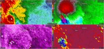
I'll add this to that post, but the closest and strongest velocity couplet to me personally was the January 2021 EF3 and here is its couplet. I imagine the April 27th 2011 would top that it passed by a similar path, but I can't find a velocity couplet screengrab of it. I'll need to scrounge around for that.The most violent personally I witnessed while covering events was this one. Same day as rolling fork. I didn't witness or stay up for the Mayfield event but I wouldve probably ranked that one 1st.
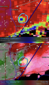
Speaking of 2021, the Brent-Centreville long tracker during the March 25 event produced one of the higher-end Vrot/CC drop combos ever recorded. That tornado almost certainly would have produced incredibly violent damage if it had affected more structures at peak intensity.I'll add this to that post, but the closest and strongest velocity couplet to me personally was the January 2021 EF3 and here is its couplet. I imagine the April 27th 2011 would top that it passed by a similar path, but I can't find a velocity couplet screengrab of it. I'll need to scrounge around for that.
I forgot about that one! I personally witnessed the tree damage with that one, where it peaked. it was very impressive.Speaking of 2021, the Brent-Centreville long tracker during the March 25 event produced one of the higher-end Vrot/CC drop combos ever recorded. That tornado almost certainly would have produced incredibly violent damage if it had affected more structures at peak intensity.
Speaking of 2021, the Brent-Centreville long tracker during the March 25 event produced one of the higher-end Vrot/CC drop combos ever recorded. That tornado almost certainly would have produced incredibly violent damage if it had affected more structures at peak intensity.
I have actually never heard about this tornado. But it 100% looks more intense on radar than the Newnan tornado did.Speaking of 2021, the Brent-Centreville long tracker during the March 25 event produced one of the higher-end Vrot/CC drop combos ever recorded. That tornado almost certainly would have produced incredibly violent damage if it had affected more structures at peak intensity.