I recently uncovered an old weather forum that had a thread with a large number of chasers discussing the Greensburg tornado. Using the Wayback Machine, I was able to archive the posts and found a website one of the members posted and discovered some pretty neat stuff.
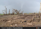
The member was a chaser who came up on the Greensburg supercell from the south on Highway-183 around 10:00 PM or so, arriving a little late to the party but just in time to capture what I believe is the only images of the supercell cycling before producing the monstrous Trousdale tornado. There was probably 200+ photos in order between the time the Greensburg tornado occluded and when the Trousdale tornado was in progress. Here’s a select few of the better images I picked out from the gallery.
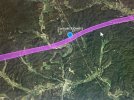
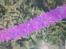
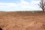
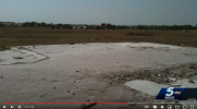
This screengrab shows the Greensburg tornado occluding and moving fully west as it crosses Highway-183 for a second time. This is as the tornado was executing a loop before it eventually stalled out and dissipated. Based on radar data, this image was taken around 10:02-10:03 PM.
View attachment 29868
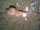
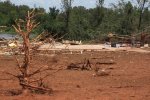
These images show what I believe is the decaying remnants of the Greensburg mesocyclone becoming involved in the new handoff northeast of town, along with a huge RFD surge racing east toward the developing circulation. The second photo is the rapidly intensifying mesocyclone that goes on to produce the Trousdale tornado. Several satellite tornadoes and smaller vortices formed in the moments prior to the Trousdale tornado touching down.
View attachment 29869View attachment 29870
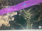
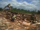
Finally, these images captured the genesis of the Trousdale tornado, and showcase just how rapidly the circulation became very large within moments of touching down. Probably going to try and enhance some of these to fully grasp what’s going on here, but the second photo shows the tornado before it wedged-out, followed by a radar image around the same time the photo was taken.
View attachment 29871
View attachment 29872View attachment 29873
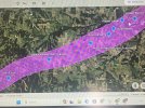
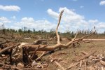
And here’s the Trousdale tornado as it expands to 2 miles in width while also being accompanied by a satellite tornado. Based on Demko and Farrar’s video and these images, the Trousdale tornado had at least 3 satellite tornadoes that appear to have gone undocumented.
View attachment 29874

")


.jpg")
.jpg")
.jpg")
.jpg")

.jpg")
.jpg")
.jpg")

.jpg")
.jpg")
.jpg")
.jpg")