
SpotlightForRareTornadoes
Member

Found this incredibly detailed tornado from '89 near Brackettville, TX. Does anyone know this one?
Follow along with the video below to see how to install our site as a web app on your home screen.
Note: This feature may not be available in some browsers.
I did one of fancy motion panorama thingies on an okay quality copy of the sheriff’s video of Pampa which is pretty notorious for the shaky handheld video, and while I wish Grazulis could’ve provided an example on how exactly he came to that 300MPH rating, I can’t say that I disagree, the motions on this are on par with Duke Evan’s video of Andover.


A lot of these Greenfield pics remind me of Joplin....this thing was definitely EF5.Some contextual damage which confirms the explosive power of the Tornado. Keep in mind the tornado was a few hundred meters wide and was moving at 55mph. It probably never spent more than 10 seconds over one area:View attachment 29981
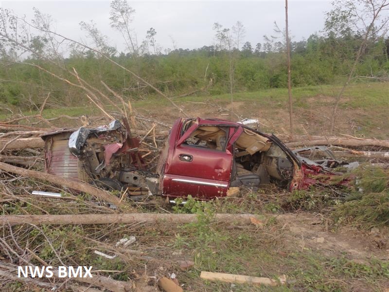
manhole cover wasn't just thrown. but lost. I wonder where it ended up.
View attachment 29982
snapped foundation and debarked trees.
View attachment 29983
These parking stops have been the center of a lot of debate. Some people have said they were atypical and had failure points where grooves were left for forklifts. This is an incorrect assumption. The width is wrong, and is too wide for forklifts. This is just a case of solid, reinforced concrete snapping off of its anchor bolts. You can see the anchor bolts sticking up where the parking stops were.
View attachment 29984
This home was built on a CMU foundation, but here you can clearly see where multiple blocks were snapped in half rather than failing between blocks. Also note the debarked trees in the background.
View attachment 29985
View attachment 29986
A piece of someone's front porch or basement foundation that was tossed. You can use the car or the junction box on the ground to the left for scale. This is a 3000 LB+ slab of concrete.
View attachment 29987
A pile of shredded debris piled around a debarked nub of a tree.
Well, the fact that DOW measured windspeeds in the Greenfield tornado went well past an EF5 (and even an F5) rating pretty much makes that indisputable...A lot of these Greenfield pics remind me of Joplin....this thing was definitely EF5.

.jpg")
.jpg")


.png")
.png")
Do you happen to have any damage photos from Cordova? Im mainly looking for contexuals or the most violent damage in general. Would be much appreciated!On the topic of 4/27/11, I'd love to find more damage pics from Enterprise, MS/Uniontown, AL and Cordova. Given what we know about Hackleburg actually being two tornadoes I wonder if there's evidence of Cordova or Enterprise being 2 or 3 separate tornadoes that were erroneously lumped together.
Scouring. In the second photo, there's debarking and a mangled tractor as well:Do you happen to have any damage photos from Cordova? Im mainly looking for contexuals or the most violent damage in general. Would be much appreciated!


This is from Paul Sirvatka's video, which IIRC was taken very near the airport in Sugar Grove.Looks like one of the 2 most wished photograph tornado (tri state and Plainfield) finally has a photographed
what appears to be 2 images of the wall cloud with the bottom one showing the tornado (its hard to see if the top one has it or not)
View attachment 30041
looks very similar to the bridge creek 1999 tornado when it had that F0 satellite orbiting around it.
edit(seems it might not be the F5 tornado but the third tornado from this mesocyclone , the Plainfield tornado was the 5 tornado form this meso, base on the time, however this does seem to be the same meso that would make this tornado)
View attachment 30042
Comstock Park:@locomusic01 do you have any damage pics from Comstock Park, MI F4 and Bluffton, OH F4 (both from April 11th, 1965 Palm Sunday outbreak)


it has that hybrid look like elie and jarrell family tornadoes didThe only Known Photo of the 1994 Birtle, MB Tornado, which occurred 30 years ago.
View attachment 30046
The tornado was rated an F4.
https://highwaysandhailstones.com/tornado/july-10-1994-birtle-manitoba-f4-tornado/
Wish there were damage photosit has that hybrid look like elie and jarrell family tornadoes did
ThanksCould've sworn I had more from Bluffton but these were the only ones in the folder:
(Edit: I think maybe I thought I had more because I was thinking of this video of the aftermath.)