
That pic looks really similar to Moore 2013. I can't find the exact picture that reminds me of it, but I know it's somewhere out there.
Navigation
Install the app
How to install the app on iOS
Follow along with the video below to see how to install our site as a web app on your home screen.
Note: This feature may not be available in some browsers.
More options
-
Welcome to TalkWeather! We see you lurking around TalkWeather! Take the extra step and join us today to view attachments, see less ads and maybe even join the discussion. CLICK TO JOIN TALKWEATHER
You are using an out of date browser. It may not display this or other websites correctly.
You should upgrade or use an alternative browser.
You should upgrade or use an alternative browser.
Significant Tornado Events
- Thread starter locomusic01
- Start date

Juliett Bravo Kilo
Member
That pic looks really similar to Moore 2013. I can't find the exact picture that reminds me of it, but I know it's somewhere out there.
This one?

I think so. I believe it was from the video that had that thumbnail.This one?View attachment 28796
jiharris0220
Member
Well I wouldn’t say it isn’t possible.Obviously no, it isn't possible for a tornado to lift an entire foundation base out of the ground.
What likely happened is that homes were swept away with such source sections of the foundation were either pulled and/or ripped off with the debris. Similar phenomena was observed with Hackleburg and Smithville.
- Thread starter
- #11,085
locomusic01
Member
There's a fair amount of stuff out there, but most of the damage just wasn't all that impressive (relatively speaking). The whole path was kinda weird and patchy with a couple small spots of F3+ mixed in. This video has some pretty good shots:For some reason it's easier to find pics from the 1913 as opposed to the 1975 Omaha tornado, haven't seen lots of these before.
There used to be an interactive map with a bunch of geolocated photos but I think it was down last time I checked. Might be accessible via the Wayback Machine but it's usually hit-or-miss w/that kinda stuff.
Sawmaster
Member
To lift and throw a normal house slab-on-grade intact would be so close to impossible that I'd be skeptical of any claims that it occurred. But I've seen some poorly done slabs which lacked any reinforcement, slabs which were much thinner than specced, and slabs poured with a poor concrete mix which tended to crumble. Those could probably be broken up and then the smaller parts thrown once the wind got under an edge and started breaking it apart. A properly done slab, even if it only had wire mesh and no rebar, would remain intact enough to act as one and thus not be dislodged even if cracked in multiple places. With rebar it would be nearly impossible to loft or even flip over a slab as the edges would resist breakage or cracking well. Maybe parts could be broken off these- that's been well documented with unreinforced slabs- but the vast majority would remain intact and in place. A smaller slab like under a shed, I can see that possibility but there's just too much mass when you reach house size to move it intact.
The 16/4/1998 Lawrence tornado family is one I like to use to test the various processing formulae that I use to try find tracks (which are NDVI, EVI, EVI2 and NDII. The presets for True Colour, NDVI and NDWI sometimes also work). The Wayne County tornado produced a very strong and wide ground scar so if what you're doing works, it should be very obvious.

One thing apparent is the offical start and end points aren't accurate. The end and start of the Wayne and Lawrence tornadoes was closer, with the Lawrence tornado further southwest and the Wayne tornado slightly further north. I can't really make out the end of the Lawrence tornado, but it was at least half a mile and probably closer a mile longer than the offical 19.3. It's hard to tell whether some marks are actually part of the tornado track or are something else, but I think the Wayne tornado may have begun further west than thought and could be closer to 35 than the offical 30 miles. Lastly the start of the Maury County tornado appears to be a mile northwest of the offical start, and much closer to the (hard to see) end of the Lawrence tornado.

There's also a possible undocumented tornado in Hardin County, to the south of the Wayne County tornado starting near the Tennessee River. I'm not sure it's a tornado mark at all, but it looks like one and I couldn't see it on images from the previous year:

I'm very much at the 'barely knows anything' level of doing this. The main thing I use is the stretch function to try improve the contrast and rely on the website to do the rest. I often end up with images that only barely show the track while having this odd greenish cast which I don't know how to get rid of, and some images - especially those taken closer to winter - simply refuse to improve their contrast. Someone who really knows what they're doing would be able to scale the data properly to a colour scale. Some people even write code that can actually discern changes between two dates, which would be incredibly useful, but it's beyond me to make what's available work.
One thing apparent is the offical start and end points aren't accurate. The end and start of the Wayne and Lawrence tornadoes was closer, with the Lawrence tornado further southwest and the Wayne tornado slightly further north. I can't really make out the end of the Lawrence tornado, but it was at least half a mile and probably closer a mile longer than the offical 19.3. It's hard to tell whether some marks are actually part of the tornado track or are something else, but I think the Wayne tornado may have begun further west than thought and could be closer to 35 than the offical 30 miles. Lastly the start of the Maury County tornado appears to be a mile northwest of the offical start, and much closer to the (hard to see) end of the Lawrence tornado.
There's also a possible undocumented tornado in Hardin County, to the south of the Wayne County tornado starting near the Tennessee River. I'm not sure it's a tornado mark at all, but it looks like one and I couldn't see it on images from the previous year:
I'm very much at the 'barely knows anything' level of doing this. The main thing I use is the stretch function to try improve the contrast and rely on the website to do the rest. I often end up with images that only barely show the track while having this odd greenish cast which I don't know how to get rid of, and some images - especially those taken closer to winter - simply refuse to improve their contrast. Someone who really knows what they're doing would be able to scale the data properly to a colour scale. Some people even write code that can actually discern changes between two dates, which would be incredibly useful, but it's beyond me to make what's available work.
Last edited:
joshoctober16
Member
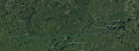
not sure where your getting these images but , try checking Lat:46.957 , Lon:-76.581The 16/4/1998 Lawrence tornado family is one I like to use to test the various processing formulae that I use to try find tracks (which are NDVI, EVI, EVI2 and NDII. The presets for True Colour, NDVI and NDWI sometimes also work). The Wayne County tornado produced a very strong and wide ground scar so if what you're doing works, it should be very obvious.
View attachment 28805
One thing apparent is the offical start and end points aren't accurate. The end and start of the Wayne and Lawrence tornadoes was closer, with the Lawrence tornado further southwest and the Wayne tornado slightly further north. I can't really make out the end of the Lawrence tornado, but it was at least half a mile and probably closer a mile longer than the offical 19.3. It's hard to tell whether some marks are actually part of the tornado track or are something else, but I think the Wayne tornado may have begun further west than thought and could be closer to 35 than the offical 30 miles. Lastly the start of the Maury County tornado appears to be a mile northwest of the offical start, and much closer to the (hard to see) end of the Lawrence tornado.
View attachment 28808
There's also a possible undocumented tornado in Hardin County, to the south of the Wayne County tornado starting near the Tennessee River. I'm not sure it's a tornado mark at all, but it looks like one and I couldn't see it on images from the previous year:
View attachment 28809
I'm very much at the 'barely knows anything' level of doing this. The main thing I use is the stretch function to try improve the contrast and rely on the website to do the rest. I often end up with images that only barely show the track while having this odd greenish cast which I don't know how to get rid of, and some images - especially those taken closer to winter - simply refuse to improve their contrast. Someone who really knows what they're doing would be able to scale the data properly to a colour scale. Some people even write code that can actually discern changes between two dates, which would be incredibly useful, but it's beyond me to make what's available work.

sometimes before 1985 , appears to have a long track tornado that went over 110+ miles
joshoctober16
Member
not sure where your getting these images but , try checking Lat:46.957 , Lon:-76.581
View attachment 28812
sometimes before 1985 , appears to have a long track tornado that went over 110+ miles

what appears to be the tornadoes from this outbreak, there's no real data on these.
Light blue = Possible tornado damage
Dark blue = F0-F3 damage
Red = F2-F5 Damage
Attachments
Ivanthetornadoenthusiast
Member
Any photos from the Berlin or Newkirk?The Hudsonville outbreak sequence was actually pretty significant. I've got a pretty good start on the 4/3 Michigan tornadoes so that isn't a problem. I've got some stuff on Davenport-Drumright, OK and a little bit on the huge Newkirk-Grenola-Toronto family, but not nearly enough to cover it the way I want. That family alone featured multiple large, violent tornadoes (including a possible F5), and that's not even mentioning the F4 that struck parts of OK-KS-MO, the Berlin, WI F4, the Lexington, TN F4 and a handful of other F3s. It'd be manageable if I knew I could find enough photos and whatnot but I suspect some of those are gonna be really tough.
The only break w/Hudsonville is with the Holland F4, which is officially counted as the same tornado. The Grand Traverse Bay F4 may've had a break southwest of Lake Ann and possibly another up around Lake Leelanau but I'm not sure yet. The Bangor-Lowell F3 probably had a break southeast of Wayland, around where the path gets kinda squirrely.
Juliett Bravo Kilo
Member
What sites do you use to find this stuff?The 16/4/1998 Lawrence tornado family is one I like to use to test the various processing formulae that I use to try find tracks (which are NDVI, EVI, EVI2 and NDII. The presets for True Colour, NDVI and NDWI sometimes also work). The Wayne County tornado produced a very strong and wide ground scar so if what you're doing works, it should be very obvious.
View attachment 28805
One thing apparent is the offical start and end points aren't accurate. The end and start of the Wayne and Lawrence tornadoes was closer, with the Lawrence tornado further southwest and the Wayne tornado slightly further north. I can't really make out the end of the Lawrence tornado, but it was at least half a mile and probably closer a mile longer than the offical 19.3. It's hard to tell whether some marks are actually part of the tornado track or are something else, but I think the Wayne tornado may have begun further west than thought and could be closer to 35 than the offical 30 miles. Lastly the start of the Maury County tornado appears to be a mile northwest of the offical start, and much closer to the (hard to see) end of the Lawrence tornado.
View attachment 28808
There's also a possible undocumented tornado in Hardin County, to the south of the Wayne County tornado starting near the Tennessee River. I'm not sure it's a tornado mark at all, but it looks like one and I couldn't see it on images from the previous year:
View attachment 28809
I'm very much at the 'barely knows anything' level of doing this. The main thing I use is the stretch function to try improve the contrast and rely on the website to do the rest. I often end up with images that only barely show the track while having this odd greenish cast which I don't know how to get rid of, and some images - especially those taken closer to winter - simply refuse to improve their contrast. Someone who really knows what they're doing would be able to scale the data properly to a colour scale. Some people even write code that can actually discern changes between two dates, which would be incredibly useful, but it's beyond me to make what's available work.
I get it from Sentinel Hub. Though I have just run out of 'requests' on my free account, so I can't download photos without credits until next month. Protip: get your imagery the way you want, then log in, download, logout.What sites do you use to find this stuff?
Ivanthetornadoenthusiast
Member
How far was that tank tossed?

Aaron Rider
Member
If I may piggy back off of this, on the note of Palm Sunday, Loco, did you ever find pictures or much information on the Rockaway, Ohio tornado?How far was that tank tossed?
- Thread starter
- #11,095
locomusic01
Member
I don't remember the context but I don't think it was, it looks like it's still sitting upright. I'll have to check and see if I have any more info though.How far was that tank tossed?
A bit, yeah. These are all the same property not far from Rockaway; it was a house with a garage/machine shop next door (first two are before/after of the house):If I may piggy back off of this, on the note of Palm Sunday, Loco, did you ever find pictures or much information on the Rockaway, Ohio tornado?


Concrete bridge pillars torn up:

Another property:


A house where a woman was killed:


Damn, any more impressive images from that event?We really need like a repository of photos for different tornadoes lol. I've got like a thousand photos from El Reno '11 but I dunno what has and hasn't been posted before.
Ivanthetornadoenthusiast
Member
Any damage pics from Toledo?I don't remember the context but I don't think it was, it looks like it's still sitting upright. I'll have to check and see if I have any more info though.
A bit, yeah. These are all the same property not far from Rockaway; it was a house with a garage/machine shop next door (first two are before/after of the house):
Concrete bridge pillars torn up:
Another property:
A house where a woman was killed:
TH2002
Member
- Messages
- 4,973
- Reaction score
- 11,113
- Location
- California, United States
- Special Affiliations
- SKYWARN® Volunteer
So, accidentally came across an unusual 'tornado coincidence'. On June 7, 2014 this weak EF0 tornado was filmed near Florissant, Missouri:
Literally the next day, this EF2 tornado touched down near Florissant, Colorado:
There are only two towns in the US named Florissant. Anyhow, not really historic or 'significant' by this thread's standards, but thought it was interesting.
Literally the next day, this EF2 tornado touched down near Florissant, Colorado:
There are only two towns in the US named Florissant. Anyhow, not really historic or 'significant' by this thread's standards, but thought it was interesting.
Ivanthetornadoenthusiast
Member
@locomusic01 (sorry for pinging you) By the way, are there any damage photos from Toledo 1965?
TH2002
Member
- Messages
- 4,973
- Reaction score
- 11,113
- Location
- California, United States
- Special Affiliations
- SKYWARN® Volunteer
Likely EF4 damage from the 2010 Moore tornado.