• Welcome to TalkWeather!
    We see you lurking around TalkWeather! Take the extra step and join us today to view attachments, see less ads and maybe even join the discussion.
    CLICK TO JOIN TALKWEATHER
Logo 468x120

locomusic01

Member
Messages
1,359
Reaction score
3,786
Location
Pennsylvania
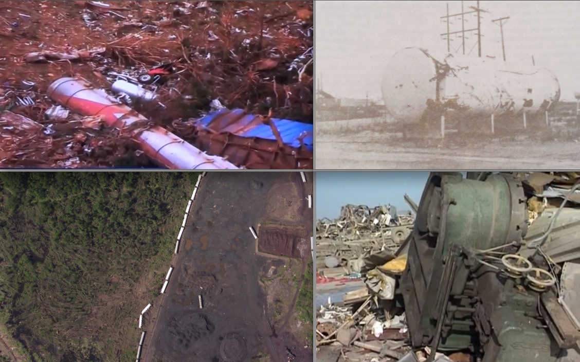
There's also this, which appears to be a truck I think? Or half a truck, anyway. Not certain, but the mangled bit of red in the first couple photos I posted may be its missing cab.

prOlYjZ.jpg


Referring to this - sort of looks like it may have been a truck cab and it's roughly the same color (accounting for differences between cameras, lighting, etc). There are also parts of another vehicle mixed in with it:

hgipAqP.jpg


This is one of my favorites just because it's so bizarre and incongruous. Not just the vehicle hangin' out in the tree, but the fact that literally the whole body is just gone while the chassis is somewhat intact (albeit wrapped almost entirely around the tree).

XDPkYnM.jpg
 

Sawmaster

Member
Messages
516
Reaction score
661
Location
Pickens SC
Special Affiliations
  1. SKYWARN® Volunteer
Never a great sign when you can't even tell how many vehicles there are, let alone what kind they were.


QTBiK9n.jpg
Almost positive this one is a Chevy Astro minivan. I have a newer GMC version so I'm familiar with certain details the average person wouldn't spot. The curved section in the foreground is the dashboard; the well-attached engine and transmission gone...

EDITED: Further review makes this most likely a Ford Aerostar. Still amazing damage!
 
Last edited:

locomusic01

Member
Messages
1,359
Reaction score
3,786
Location
Pennsylvania
Almost positive this one is a Chevy Astro minivan. I have a newer GMC version so I'm familiar with certain details the average person wouldn't spot. The curved section in the foreground is the dashboard; the well-attached engine and transmission gone...
Good eye! I posted the video the screenshot was taken from in my article and you can hear someone in the background say the van is a Ford Aerostar, but it does kinda look more like a Chevy Astro. At least from the few details you can actually make out, anyway. Here's the video:


And the engine sitting by itself some distance away:

Pq2vr0A.jpg
 

Sawmaster

Member
Messages
516
Reaction score
661
Location
Pickens SC
Special Affiliations
  1. SKYWARN® Volunteer
Good eye! I posted the video the screenshot was taken from in my article and you can hear someone in the background say the van is a Ford Aerostar, but it does kinda look more like a Chevy Astro. At least from the few details you can actually make out, anyway. Here's the video:


And the engine sitting by itself some distance away:

Pq2vr0A.jpg

That's not a 4.3 Chevy V6 which most Astros' had,and the EGR parts more resemble what you usually find on Fords. Good chance it IS an Aerostar!
 

locomusic01

Member
Messages
1,359
Reaction score
3,786
Location
Pennsylvania
Good eye! I posted the video the screenshot was taken from in my article and you can hear someone in the background say the van is a Ford Aerostar, but it does kinda look more like a Chevy Astro. At least from the few details you can actually make out, anyway. Here's the video:


And the engine sitting by itself some distance away:

Pq2vr0A.jpg

Incidentally, worth pointing out this was at the 16th St overpass north of Newcastle, which is right around where the occlusion process appears to have started. The tornado rapidly contracted, recurved northward and began to "weaken" before the occlusion ultimately failed and it hulked out again.

The aerial photos make this quite clear - this is looking ENE toward the overpass with the Canadian River in the distance:

HYFHWlX.jpg


This is just east of I-44 and south of the river where the final phase of the failed occlusion began:

Ca2QS4C.jpg


Edit: Also, I've posted this before but this is another car that was parked beneath the overpass (along with its owner). It wasn't found for almost a week because it had been hurled just over a mile:

0LSob8r.jpg
 

pohnpei

Member
Messages
962
Reaction score
1,966
Location
shanghai
Incidentally, worth pointing out this was at the 16th St overpass north of Newcastle, which is right around where the occlusion process appears to have started. The tornado rapidly contracted, recurved northward and began to "weaken" before the occlusion ultimately failed and it hulked out again.

The aerial photos make this quite clear - this is looking ENE toward the overpass with the Canadian River in the distance:

HYFHWlX.jpg


This is just east of I-44 and south of the river where the final phase of the failed occlusion began:

Ca2QS4C.jpg


Edit: Also, I've posted this before but this is another car that was parked beneath the overpass (along with its owner). It wasn't found for almost a week because it had been hurled just over a mile:

0LSob8r.jpg

Based on this video, I think the lower portion of the first pic was most likely where 301mph got recorded by DOW. One thing to note was the measurement was highest when DOW team got closest to the tornado and quite far away from the tornado when it was near Willow Lake and Bridge Creek which means winds could be higher there given the damage it did.
 

locomusic01

Member
Messages
1,359
Reaction score
3,786
Location
Pennsylvania
Based on this video, I think the lower portion of the first pic was most likely where 301mph got recorded by DOW. One thing to note was the measurement was highest when DOW team got closest to the tornado and quite far away from the tornado when it was near Willow Lake and Bridge Creek which means winds could be higher there given the damage it did.
The highest DOW velocities were recorded around 2354 UTC (6:54 pm), at which point the tornado would've been just a bit southwest of that first aerial photo. More in the area of the huge swath of scoured ground at bottom right here (looking ENE w/the overpass in the distance):

54tlCcd.jpg


Wider shot looking SSE - the tornado would've been basically in the center or slightly left of center at the time of the highest DOW scans:

PVQqfYz.jpg


Another view showing the section of the path just east of the last shot:

w4CSrG7.jpg


And again moving further east - the overpass is right along the left edge of the photo here:

3EmpRRA.jpg


And while I'm here I'm gonna take the excuse to post this photo again because I think it's incredible. This is taken from Hwy 76 (N. Council Ave) looking ENE toward the overpass:

rnV5G7v.jpg
 

Western_KS_Wx

Member
Messages
210
Reaction score
592
Location
Garden City KS
Here’s some more Moore 2013 damage pictures:
B31CA382-C880-4C91-8892-4871A7F46ACB.jpeg
5C594E62-0184-481F-89DF-7061EA1E2F51.jpeg
D83E67E5-FBF8-4B11-AB7C-15AA2182D547.jpeg
This is Plaza Towers where the ground around the school was completely scoured and debris was pulverized to bits.
E92C3738-2483-4B0F-9574-1DECA2DE953C.jpeg
2D4901E8-3BE5-4745-801D-BCA364B2DF0B.jpeg
392C6830-34D1-4C08-8E89-1FF69AA0C33D.jpeg
7BB67D2E-684C-435E-B08F-AC857E3A652B.jpeg
D11836D4-A1B9-4C98-8878-678D94929D57.jpeg
I actually think the tornado hit a secondary peak around the Plaza Towers area where the widest swath of violent EF4+ damage occurred and contextual damage was just incredibly violent. Right across Plaza Towers an entire row of homes on each side of SW 14th Street all but literally vanished. The last photo is looking towards the school and you can see just the rows of slabs along the street.
F05E5003-E3A8-43BF-8F62-B6AF94404D9D.jpeg
85A5862F-927D-4540-B5B3-6E1B2796CBA2.jpeg
Here’s some shots outside of Moore. The damage left by this tornado was pretty close up there with some of the damage left behind in Bridge Creek and Jarrell.
 
Messages
2,233
Reaction score
2,823
Location
Missouri
This is probably a relevant Twitter post for this thread (especially in the context of Bridge Creek recently being shared).


I always thought that wind speeds in tornadoes decrease the lower you are because ground friction, now it looks like that's being called into question. It makes sense to me, as damage from Jarrell, Smithville and Bridge Creek-Moore 1999 were probably done by wind speeds ~320-330 mph right at the Earth's surface; I don't know how that kind of damage can be done by anything less.
 

locomusic01

Member
Messages
1,359
Reaction score
3,786
Location
Pennsylvania
I always thought that wind speeds in tornadoes decrease the lower you are because ground friction, now it looks like that's being called into question. It makes sense to me, as damage from Jarrell, Smithville and Bridge Creek-Moore 1999 were probably done by wind speeds ~320-330 mph right at the Earth's surface; I don't know how that kind of damage can be done by anything less.
That's still probably true, it's just a matter of where that drop-off starts. The lowest-level data included in the paper is 15 m (~50 ft), so still fairly high above the ground. There's just not much data below that for obvious reasons, although they mention that max velocities may occur as low as 5 m (~16 ft). Here's the relevant bit:

There are not yet sufficient tornado wind speed observations from <15 m ARL to extend the profile shown in Fig. 4 to the standard meteorological observation height of 10 m AGL. Residential structures common in tornado-prone areas typically extend from the ground to only about 3 m (single-story manufactured homes), 5 m (single-story house) or 8 m (two-story houses), with first stories centered at about 2 m AGL. Critically, the strength of winds in the 0–15 m AGL layer in the presence of man-made structures and trees are nearly impossible to sample by radar due to blockage from those same objects. Therefore, very near ground tornado Vg in built environments remain rarely sampled. Case study results suggest that maximum intensity winds may sometimes occur as low as 5 m AGL, but the radar data used in those studies were obtained over open land, not near or between houses and trees27. Observations very near the ground by anemometers at 3 m AGL27,31 and at 1 m AGL32 suggest that peak wind gusts (Vg) in the 1–3 m AGL layer are less than or comparable to those measured by radars above the anemometers, but the impact of the built environment on these observations in unknown.
 

pohnpei

Member
Messages
962
Reaction score
1,966
Location
shanghai
That's still probably true, it's just a matter of where that drop-off starts. The lowest-level data included in the paper is 15 m (~50 ft), so still fairly high above the ground. There's just not much data below that for obvious reasons, although they mention that max velocities may occur as low as 5 m (~16 ft). Here's the relevant bit:
And this was the case that winds keep strengthing as low as 5m. It's from Russell KS May 25 2012. Winds at 5m level was 10% stronger than winds at 10m level and 25% stronger thn winds at 40m level. This was very few case that DOW got winds lower than 10m yet winds still peaked at lowest level!
IMG_20230225_085257.jpg
Another case was 2018 Inola tornado on August 19. Winds at 2m was 13% stronger than winds at 10m level. These winds were measured by mesonet site and it was the actual winds speed of the tornado. What DOW got was the velocity of the tornado not actual wind speed. Being that said, "Bridge Creek had 301mph winds measured by DOW" isn't that accurate.
The transformation of DOW velocity and maximum near surface winds was discussed in this paper
While the peak tangential winds at the top of the boundary layer have been occasionally observed by portable Doppler radars, we use these simulations to estimate the mean and transient surface winds (defined at z = 10 m) that might actually be occurring for a given value of {V}max and other parameters. For each case, three measures of intensity were computed that are representative of the low-level wind and the damage it might cause: the time–azimuthal-mean horizontal surface wind speed {S10}max; the time mean of the maximum horizontal wind gusts S10-3s occurring anywhere; and the time mean of the maximum vertical wind gusts W10-3s. The value of {S10}max is generally about 15% less than {V}max but increases with decreasing surface roughness. Values of maximum S10-3s are, on average, 10%–20% greater than {V}max, but S10-3s can occasionally be 40%–50% greater than {V}max. The simulations show surprisingly large values for vertical velocities only 10 m above the surface: typically the maximum values of W10-3s are about 33% of {V}max—for example, 20–30 m s−1, with transient values exceeding 50 m s−1.
IMG_20230225_093048.jpg
I think it's reasonable that winds could be lower at 1-3m level compared with 10-15m level for those tornados entering into towns due to friction.But the overall momentum could still be stronger compared with 10-15m level because the large amount of debris in tornado's flow can offset the possible decrease of wind speed. Also the stronger the tornado, the more amounts of debris it can carry and the larger the momentum it could be. The density of the flow in these strongest tornados at lower level could be significantly different than the normal air density.

That's part of the reason that EF5 tornado could do way stronger damage than strongest hurricanes(winds alone). Even some hurricanes do have 300mph+ gust(irma likely had gust as high as 188m/s in st.martin)

These mostly are assumptions and we still pretty much know nothing about the behavior of tornado winds lower than 10m level for now. We have no idea what kinds of wind speed or how large the overall momentum Bridge Creek had lower than 10m which was the level most of its damage had been done.
 
Last edited:

A Guy

Member
Messages
175
Reaction score
345
Location
Australia
If we're talking about strong winds close to the ground, I still maintain a photogrammetry study could be handy. It won't show you what's going on in the centre, but it'll show you something.
 
Messages
2,233
Reaction score
2,823
Location
Missouri
If we're talking about strong winds close to the ground, I still maintain a photogrammetry study could be handy. It won't show you what's going on in the centre, but it'll show you something.
Assuming you view photogrammetry as reliable, yeah. Grazulis said that photogrammetric studies of Pampa, TX demonstrated wind speeds right around 300 mph at the surface of the Earth, sounds about right from the rotation on that thing.
 
Messages
511
Reaction score
433
Location
Northern Europe
On another note, does anyone think that the Delhi LA “F5” on 21 Feb 1971 deserved its rating? So far I haven’t seen structural evidence to substantiate it; though @locomusic01 posted aerials that revealed extensive debarking, debarked trees cannot be assigned a rating higher than E/F4. All the homes that were destroyed, including the Lenore home, appear to have been poorly constructed. The images of the Lenore property don’t really show clear-cut textual evidence of high-end DIs; the black-and-white imagery doesn’t even show unambiguous evidence of vegetative debarking.
 

MNTornadoGuy

Member
Messages
1,625
Reaction score
2,599
Location
Apple Valley, MN
On another note, does anyone think that the Delhi LA “F5” on 21 Feb 1971 deserved its rating? So far I haven’t seen structural evidence to substantiate it; though @locomusic01 posted aerials that revealed extensive debarking, debarked trees cannot be assigned a rating higher than E/F4. All the homes that were destroyed, including the Lenore home, appear to have been poorly constructed. The images of the Lenore property don’t really show clear-cut textual evidence of high-end DIs; the black-and-white imagery doesn’t even show unambiguous evidence of vegetative debarking.
The photos that TornadoTalk has in its article do show some pretty clear evidence of debarking though the house appears to have been poorly-built and probably doesn't support an F5 rating.
 

Western_KS_Wx

Member
Messages
210
Reaction score
592
Location
Garden City KS
On the topic of Pampa, I’ve always thought the thing was very likely an F5 and was probably stronger than the Elie tornado. The video of vehicles flying hundreds of yards in the air, rotation, debris velocity, and the movement of a 30,000 pound object all seems to point to incredibly high winds. Does anyone have some damage photos from the event? I remember seeing some on this one documentary a while back that showed some incredibly intense damage but have yet to find or see it again. Seems like a lot of the damage from the 3 monster F4 tornadoes that day was rather poorly documented.
 
Messages
2,233
Reaction score
2,823
Location
Missouri
On the topic of Pampa, I’ve always thought the thing was very likely an F5 and was probably stronger than the Elie tornado. The video of vehicles flying hundreds of yards in the air, rotation, debris velocity, and the movement of a 30,000 pound object all seems to point to incredibly high winds. Does anyone have some damage photos from the event? I remember seeing some on this one documentary a while back that showed some incredibly intense damage but have yet to find or see it again. Seems like a lot of the damage from the 3 monster F4 tornadoes that day was rather poorly documented.
This post:


TornadoTalk:


Another post of mine. No close up photos but a ton of visible debris:


Also, it moved a 35,000 pound lathe:


Further down on the extemeplanet page you'll find a mention of Pampa having particle motions of 300 mph just above ground level.

Another post with damage screenshots:


This old TLC documentary is a source of a ton of photos:


As to why this outbreak is so poorly documented apparently the damage surveys from this thing were accidentally discarded years ago, according to various Internet forums. Shame, given how this is an impressive regional outbreak.
 
Back
Top