
Western_KS_Wx
Member
Probably Tuscaloosa, still having some issues overlaying the imagery for Mayfield. I’ve got a section near Benton to load properly but everything else im still trying to work out.which map are you gonna finish first?
Follow along with the video below to see how to install our site as a web app on your home screen.
Note: This feature may not be available in some browsers.
Probably Tuscaloosa, still having some issues overlaying the imagery for Mayfield. I’ve got a section near Benton to load properly but everything else im still trying to work out.which map are you gonna finish first?
kkProbably Tuscaloosa, still having some issues overlaying the imagery for Mayfield. I’ve got a section near Benton to load properly but everything else im still trying to work out.

Hey, remember this? I was just browsing WesternKsWx's twitter account and randomly searched up his posts on Mullinville and I found this.I've essentially given up hope of there being any Mullinville photos.


how much progress have you made back so far...?Probably Tuscaloosa, still having some issues overlaying the imagery for Mayfield. I’ve got a section near Benton to load properly but everything else im still trying to work out.
I'm retracting this. Per Will Reid himself, no actual tornado was in progress at this point.Hey, remember this? I was just browsing WesternKsWx's twitter account and randomly searched up his posts on Mullinville and I found this.
View attachment 14942
Now, I don't know where exactly the tornado is in the photo, but he put this in a post all about the Mullinville tornado so I'm fairly certain the tornado is in this photo. I have 3 specific areas I'm keeping my eye on:
View attachment 14943
The area I'm most confident about is on the far right of the image, but I'm still slightly unsure. @Western_KS_Wx can you help clear things up a bit?

So the mesocyclone they’re looking at in the center of the screen and the one they photographed the most is actually an occluding meso that spawned the two brief tornadoes prior to Mullinville.Hey, remember this? I was just browsing WesternKsWx's twitter account and randomly searched up his posts on Mullinville and I found this.
View attachment 14942
Now, I don't know where exactly the tornado is in the photo, but he put this in a post all about the Mullinville tornado so I'm fairly certain the tornado is in this photo. I have 3 specific areas I'm keeping my eye on:
View attachment 14943
The area I'm most confident about is on the far right of the image, but I'm still slightly unsure. @Western_KS_Wx can you help clear things up a bit?
I'm retracting this. Per Will Reid himself, no actual tornado was in progress at this point.
BUT:
Is it a raincore? A microburst? No, it's Mullinville!
View attachment 14944


Do consider yourself patient because I've shattered laptop screens with my fist on at least two occasions, also shattered the screen on my previous phone by chucking it across the room, lol.Lol I wouldn’t exactly say I was too patient when this happened but I sort of just accepted it and thought putting a fist through the screen probably wouldn’t have helped the situation, I’d be lying if I said the thought didn’t cross my mind though.
interesting. i tried getting into arcgis but was not prepared for it lol.Do consider yourself patient because I've shattered laptop screens with my fist on at least two occasions, also shattered the screen on my previous phone by chucking it across the room, lol.
Hoping that doesn't happen to the new ThinkPad I just bought cause I need it to run ArcGIS, working on a certification in that field but also using it to map out some tornadoes. Focus is Shoal Creek Valley currently, an incredible (and rather overlooked IMO) Super Outbreak tornado which my next post will be about.


Interesting, I’ve never seen these aerial images before from this tornado. I’ve always thought Shoal Creek was on the same level as Tuscaloosa in terms of violence and it too likely reached EF5 status. They both traveled around the same distance as well (Tuscaloosa ~92 miles, Shoal Creek ~98miles) it’s a shame Shoal Creek is so overlooked and has little info on it.The Shoal Creek Valley tornado was an extremely violent storm and had one of the most impressively persistent violent damage swaths I have ever seen, and that's saying something considering it's far from alone in the club of impressive Super Outbreak tornadoes.
For the first 13 miles of its path the tornado essentially paralleled Shoal Creek Road; within five miles of touching down the tornado was already obliterating homes and scouring the ground, and homes were leveled or swept away almost to the very end of the path.
Note that I'm gonna have to split this into two separate posts, so bear with me. Anyways, here's some of the damage along Shoal Creek Road:
View attachment 14952
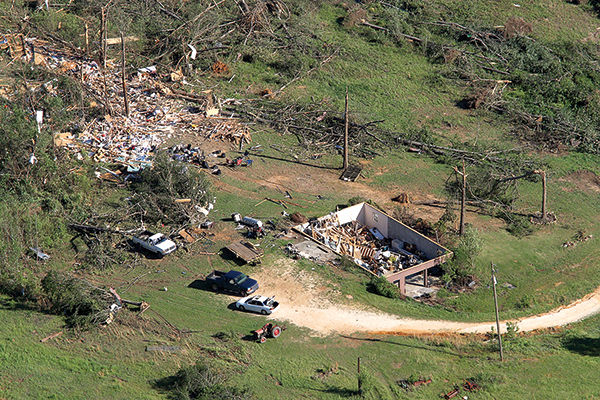
The home in the bottom left corner was one of the first to be hit, and the first that was swept away. The tornado's violent core likely passed just north of the house. Debris impact marks and scouring are evident on the neighboring property.
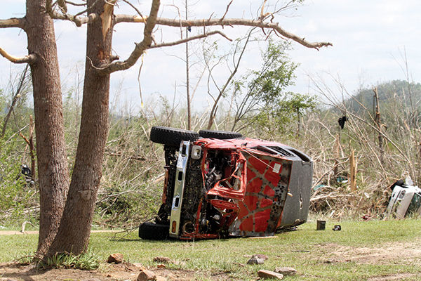
About a mile and a half further up the path, the tornado struck the Alpha Ranch foster home. Despite not even taking a direct hit, the house was completely destroyed; with the exception of its collapsed chimney and a part of the subfloor, the foundation was swept clean. A large shed/outbuilding was also swept clean, and farm implements were reportedly thrown up to a half mile away. Denuded/debarked trees and wind damaged grass marked the tornado's inner core in this area.
View attachment 14955
View attachment 14957
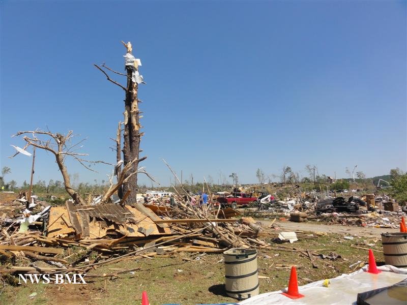
As the tornado approached Neely Lake, it continued to obliterate block foundation homes all the way to the lake shore, where yet more homes were leveled or swept away, vehicles were tossed, and trees were debarked.
Crossing the lake into Calhoun County, the tornado began to fluctuate in intensity after destroying additional lakeside homes in the northern edge of Ohatchee. Still, many trees were downed, site built homes were severely damaged and mobile homes and outbuildings were destroyed in this rural area. It had intensified again by the time it struck a cluster of homes at the intersection of Rock Springs Rd and Gilberts Ferry Rd in Ohatchee; mobile homes vanished and a two story home was left as a concrete slab.
View attachment 14958
OOO. you need to convince the guys that work on tornado archive to put some of your maps. especially of mayfield into there data viewer! that would be dope!Interesting, I’ve never seen these aerial images before from this tornado. I’ve always thought Shoal Creek was on the same level as Tuscaloosa in terms of violence and it too likely reached EF5 status. They both traveled around the same distance as well (Tuscaloosa ~92 miles, Shoal Creek ~98miles) it’s a shame Shoal Creek is so overlooked and has little info on it.
Might have to consider lol, I doubt they’d take the full detail map probably just the EF0 if they were to take me up on it. Mentioning Tuscaloosa, the path length is quite a bit longer than what the NWS and storm data lists, there was pretty consistent damage for about 30 miles outside of Tuscaloosa before it weakened significantly around I-20, but the full length was 92 miles.OOO. you need to convince the guys that work on tornado archive to put some of your maps. especially of mayfield into there data viewer! that would be dope!
yassss. hows tuscaloosa coming back along btw?Might have to consider lol, I doubt they’d take the full detail map probably just the EF0 if they were to take me up on it. Mentioning Tuscaloosa, the path length is quite a bit longer than what the NWS and storm data lists, there was pretty consistent damage for about 30 miles outside of Tuscaloosa before it weakened significantly around I-20, but the full length was 92 miles.
Hate to admit it but I’ve been slacking a little bit ever since the ‘great crash’ happened lol. However the EF1 swath is pretty much done just need to finish about 5-6 more miles in the beginning of the path. Also due to how ridiculously complex and squirrelly the damage path was the EF1-2 contours are taking a little longer than I expected, but I’d imagine the EF3-4+ swaths will take less time.yassss. hows tuscaloosa coming back along btw?
would it be of too much bother to share each new EF-scale polygon number as it's completed? to see the progression up the scale? or is that too much...Hate to admit it but I’ve been slacking a little bit ever since the ‘great crash’ happened lol. However the EF1 swath is pretty much done just need to finish about 5-6 more miles in the beginning of the path. Also due to how ridiculously complex and squirrelly the damage path was the EF1-2 contours are taking a little longer than I expected, but I’d imagine the EF3-4+ swaths will take less time.