• Welcome to TalkWeather!
    We see you lurking around TalkWeather! Take the extra step and join us today to view attachments, see less ads and maybe even join the discussion.
    CLICK TO JOIN TALKWEATHER
  • April 2024 Weather Video of the Month
    Post your nominations now!
Logo 468x120
Messages
2,235
Reaction score
2,827
Location
Missouri
Thanks, I've seen it attributed to both but I'm not sure exactly where it was taken. Seeing if I could track down Carrie Kinslow has always been on my "maybe some day" list lol. Also, I was looking thru my folder for this event and found a random shot from the F3 that struck near Tidwell, TN:

tidwell-tn-F3-nails-creek-dr.jpg


It's not as egregious as a couple of the other would-be F5s, but you could make a pretty good case. It did some truly phenomenal things. It's one (or two if you count both, I guess) of at least a half-dozen tornadoes that very likely would've earned F5 ratings if they'd occurred at other times and/or in other places. I still can't say that I really understand why so many of the Palm Sunday tornadoes ended up so clearly underrated.
The more I think about it the Kinslow pic might actually just be the tornado's wall cloud, not the tornado itself.
I'd love to find more damage photographs from the other two F4's as well as the F5 from this outbreak but my guess is that won't happen anytime soon. Oh well.
 

locomusic01

Member
Messages
1,361
Reaction score
3,796
Location
Pennsylvania
So it would seem the Grand Valley F4 did indeed produce some rather intense ground scouring in at least a few places. I posted some photos earlier in the thread from the Tottenham area, but the (purported) scouring was so extensive that I was pretty skeptical. Well, the evidence is starting to add up now. I've talked to three other people in the last few days who all independently described some version of scouring ("the grass was torn out" or "the ground was dug up," that sort of thing). One woman also had pictures of it.

I'm still waiting on her to send the higher-quality versions (she just snapped a few quick pictures of her photo album w/her phone) but even with the dreadful quality here you can more or less make out exactly what she described: the grass in the background is healthy and green while the foreground looks like somebody ran a gigantic tiller over it. She estimated it was maybe 50-100m at its widest point.

tottenham-scour.jpg
 
Messages
2,235
Reaction score
2,827
Location
Missouri
So it would seem the Grand Valley F4 did indeed produce some rather intense ground scouring in at least a few places. I posted some photos earlier in the thread from the Tottenham area, but the (purported) scouring was so extensive that I was pretty skeptical. Well, the evidence is starting to add up now. I've talked to three other people in the last few days who all independently described some version of scouring ("the grass was torn out" or "the ground was dug up," that sort of thing). One woman also had pictures of it.

I'm still waiting on her to send the higher-quality versions (she just snapped a few quick pictures of her photo album w/her phone) but even with the dreadful quality here you can more or less make out exactly what she described: the grass in the background is healthy and green while the foreground looks like somebody ran a gigantic tiller over it. She estimated it was maybe 50-100m at its widest point.

tottenham-scour.jpg
So this thing is living up to the hype? Interesting, why is it so difficult to find photographs from F4-F5 damage from this outbreak (I once thought this to be a problem largely for older events but apparently it can sometimes happen with more recent ones)?
Anyways, awesome progress, really hope you're able to find more photograph from Grand Valley and a couple of other tornadoes from this outbreak soon!
 

locomusic01

Member
Messages
1,361
Reaction score
3,796
Location
Pennsylvania
So this thing is living up to the hype? Interesting, why is it so difficult to find photographs from F4-F5 damage from this outbreak (I once thought this to be a problem largely for older events but apparently it can sometimes happen with more recent ones)?
Anyways, awesome progress, really hope you're able to find more photograph from Grand Valley and a couple of other tornadoes from this outbreak soon!
It seems to have been more intense than I thought, at least. Almost all of what's normally available comes from Grand Valley itself, where the vast majority of the damage is F2-F3 at worst, but the hardest-hit areas were closer to the middle of the path (Tottenham especially, but also Orangeville/Hockley Valley). It weaved its way around those communities though, so it didn't really hit that much. Not directly, anyway.

As far as I can tell, probably no more than a few dozen houses were completely destroyed and maybe another 50 or so suffered any kind of significant damage throughout the path (not counting Grand Valley). People just didn't pay much attention to it, especially in comparison to Barrie. I mentioned the other day that the Corbetton F3 was surprisingly intense as well, but you'd hardly even know there were any tornadoes outside of Barrie. There are actually a few photo collections in various libraries, historical societies, etc. around Ontario, but I haven't had much luck with them since I don't live in Canada.

And yeah, the relative lack of photos (especially of high-end damage) in general is very frustrating. You'd think being relatively recent, and happening where it did, it would be incredibly well-documented. I suppose you can chalk a lot of it up to the phenomenon we've talked about before, where people tend to gravitate toward the more eye-catching moderate damage instead of the really violent stuff that, to the untrained eye, probably doesn't look as compelling.

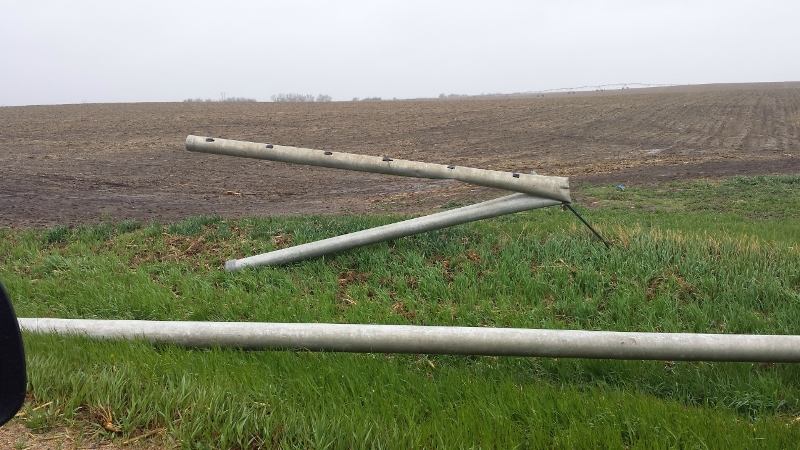
Oh, and speaking of other Grand Valley photos, I forgot to mention that there was apparently another smallish area of scouring just outside of Arthur, very near where the tornado first touched down. Really need to find some color photos, but even in B&W it's pretty clear to see the bare, muddy streak (along w/some bits of torn-up farm equipment):

arthur-area-barn-destroyed.jpg
 

locomusic01

Member
Messages
1,361
Reaction score
3,796
Location
Pennsylvania
Oh wow that is pretty impressive. Did this tornado produce any other impressive contextual damage?
Not too far from that photo is the area (or at least one of the areas) where I suspect the tornado may have reached peak intensity. I was actually just working on that bit of my draft so I'll just copy/paste it:

The tornado thundered across a rural stretch of Adjala Township, tearing up trees but encountering few structures. That changed almost immediately as the twister crossed the Adjala Tecumseth Townline two miles southwest of Tottenham. Cutting across the 3rd Line at a shallow angle, it first blew through a dairy farm owned by Jack Maher.

Although he and his house were spared, that was the extent of Maher’s good fortune. His barn was totally destroyed, killing several prized Holstein cows and completely wrecking the costly milking equipment inside. A $70,000 steel-reinforced silo was flattened and most of the farm equipment was totaled, including a hay wagon thrown by the wind and “twisted like plasticine.”

The vortex gradually narrowed and gained strength as it sped along the 3rd Line, drifting slowly from the north side of the road to the south. It tore apart barns and outbuildings and blew away multiple homes, flinging pieces of shrapnel in every direction. At one farm, a multi-ton combine was crumpled into a ball and deposited half a mile away. At another, a steel tank that had been strapped to a concrete pad was snatched up and tossed into a stand of shredded and denuded trees.

Directly south of Tottenham, Joan MacDonald huddled in her basement as the home above her was swept cleanly away in a matter of seconds. Her mother, who'd been standing in the bathroom at the time, survived by wrapping herself around the toilet — the only thing still standing atop the foundation after the winds subsided. The family car was hurled hundreds of yards into a field, its roof smashed flat and much of its drivetrain missing.
Incidentally, the MacDonald house is the one I believe I posted a picture of a while back:

macdonald-home-only-toilet-left.jpg
 

locomusic01

Member
Messages
1,361
Reaction score
3,796
Location
Pennsylvania
Also, I'm sure I've mentioned it before, but it's pretty damn impressive that all of this was done while the tornado was cruising along at speeds of up to 60 mph at times. Many people recounted that the tornado itself only lasted a matter of seconds. One person described it as "like being hit by a blast wave."
 

locomusic01

Member
Messages
1,361
Reaction score
3,796
Location
Pennsylvania
I'm still waiting on her to send the higher-quality versions (she just snapped a few quick pictures of her photo album w/her phone) but even with the dreadful quality here you can more or less make out exactly what she described: the grass in the background is healthy and green while the foreground looks like somebody ran a gigantic tiller over it. She estimated it was maybe 50-100m at its widest point.
One more from the same area. Really anxious to see the proper high-quality version of this one (without the corner of another photo peekin' out). Haven't heard any info yet about the vehicle but I'm wondering if it might be the MacDonald family car I mentioned above.

kim-beckner-home-2-2.jpg


Edit: Okay so I lied - one more. This one appears to be more toward the edge of the path and you can see the grass sort of torn out in chunks rather than completely scoured down to the soil.

kim-beckner-home-2-3.jpg
 
Last edited:

locomusic01

Member
Messages
1,361
Reaction score
3,796
Location
Pennsylvania
While I'm hijacking the thread, there's also this from the Hockley Valley, north of Orangeville and immediately east of the Mono Plaza that was partly leveled.

hockley-valley-near-mono-plaza-chris-kasparian.jpg


I've heard some vague descriptions from the area that sort of sound like scouring, but I'm inclined to think what's shown at lower right here is more likely just an artifact of the photo itself. The tornado was very strong as it passed through this area, but it's still a good 10 miles from where it seems to have maxed out.
 

MNTornadoGuy

Member
Messages
1,625
Reaction score
2,599
Location
Apple Valley, MN
Some NWS products from 5/31/1985:
CONVECTIVE OUTLOOK...REF AFOS NMCGPH92O

VALID 312000 - 011200Z

THERE IS A SLGT RISK OF SVR TSTMS TO THE RT OF A LN ART AVP
BWI LYH HSV TUP TXK SPS LTS GAG P28 SGF CGI EVV 30 ENE TOL.

GEN TSTMS FCST TO THE RGT OF A LN FM AQQ LUL HEZ LFK AUS LRD
...CONT...70 S TUS GBN EED BIH UKI...CONT...30 N 63S S80
CPR HLC STL SPI DBQ MSP 70 WNW INL.

HAVE DOWNGRADED ERYR MDT RISK AREA IN VIEW OF WK LO LVL CNVGC AND
LACK OF STG SFC HTG ACRS OH..WV AND MUCH OF PA. HVWR...AMS STILL
QUITE UNSTBL SO ISOLD SVR TSTMS STILL PSBL THRUT THIS RGN. OTR
ISOLD SVR TSTMS PSBL SWWD ALG CD FNT WHERE AMS ALSO QUITE UNSTBL.

ISOLD SVR TSTMS PSBL LT IN PD IN WM ADVCTN/OVRRUNNINGD ZONE ALG/N
OF WRN END OF CD FNT. MDLS INDICATE FVRBL VERT SHEAR THIS AREA
AS SLY LO LVL FLOW OF UNSTBL AMS INCRSS.

BULLETIN - IMMEDIATE BROADCAST REQUESTED
TORNADO WATCH NUMBER 211
NATIONAL WEATHER SERVICE KANSAS CITY MO
425 PM EDT FRI MAY 31 1985

A..THE NATIONAL SEVERE STORMS FORECAST CENTER HAS ISSUED A
TORNADO WATCH FOR

PORTIONS OF EASTERN OHIO
PORTIONS OF THE NORTHERN PANHANDLE OF WEST VIRGINIA
PORTIONS OF WESTERN PENNSYLVANIA
PARTS OF SOUTHWEST NEW YORK
PORTIONS OF CENTRAL AND EASTERN LAKE ERIE
SOUTHERN LAKE ONTARIO

FROM 500 PM EDT UNTIL 1100 PM EDT THIS FRIDAY AFTERNOON AND
EVENING

TORNADOES ....LARGE HAIL....DANGEROUS LIGHTNING AND DAMAGING
THUNDERSTORM WINDS ARE POSSIBLE IN THESE AREAS.

THE TORNADO WATCH AREA IS ALONG AND 70 STATUTE MILES NORTH AND SOUTH
OF A LINE FROM 20 MILES WEST SOUTHWEST OF AKRON OHIO TO 20 MILES
SOUTH OF ROCHESTER NEW YORK

REMEMBER....A TORNADO WATCH MEANS CONDITIONS ARE FAVORABLE FOR
TORNADOES AND SEVERE THUNDERSTORMS IN AND CLOSE TO THE WATCH AREA.
PERSONS IN THESE AREAS SHOULD BE ON THE LOOKOUT FOR THREATENING
WEATHER CONDITIONS AND LISTEN FOR LATER STATEMENTS AND POSSIBLE
WARNINGS.

C...TORNADOES AND A FEW SVR TSTMS WITH HAIL SFC AND ALF TO 2 IN.
EXTRM TURBC AND SFC WND GUSTS TO 70 KT. A FEW CBS WITH MAX TOPS TO
520 . MEAN WIND VECTOR 250/35 .

D... STG TSTM ACTVTY DVLPG SWD FM SRN ONTARIO AND VCNTY ERN OH EXPCD
TO INTSFY NXT SVRL HRS AS UPRb SHRT WAVE TROF ROTATES EWD ACRS GREAT
LAKES REGION. AMS IS WARM AND UNSTBL WITH LIFTED INDEX OF MINUS 8.
ACTVTY FCST TO MOVE EWD INTO AREA OF FVRBL SFC PRES FALLS.

...WEISS

000
WOUS00 KERI 010000
^PITTORERI
BULLETIN ACTIVATE EBS
TORNADO WARNING
NATIONAL WEATHER SERVICE ERIE PA
600 PM EDT FRI MAY 31 1985 EXPIRES 700 PM EDT

COUNTIES AFFECTED PA VENANGO WARREN


THE NATIONAL WEATHER SERVICE IN ERIE HAS ISSUED A TORNADO WARNING UNTIL
700 PM FOR THESE COUNTIES IN NORTHWESTERN PENNSYLVANIA VENANGO WARREN
AT 600 PM ERIE WEATHER RADAR INDICATED A TORNADO IN SOUTHEASTERN
CRAWFORD COUNTY MOVING EAST AROUND 35 MILES AN HOUR TOWARD NORTHERN
VENANGO COUNTY. ANOTHER TORNADO WAS INDICATED WEST OF CORRY
PENNYSLVANIA MOVING EAST AT 35 MILES ANHOUR TOWARD NORTHERN WARREN COUNTY.
A THIRD TORNADO WAS INDICATED NEAR CAMBRIDGE SPRING MOVING EAST AT 35
MILES AN HOUR.


THESE STORMS ALSO CONTAIN DAMAGING WIND..HAIL..HEAVY RAIN..AND DANGEROUS
LIGHTNING.

000
TTAA00 KCLE 010800

PUBLIC INFORMATION STATEMENT
NATIONAL WEATHER SERVICE CLEVELAND OH
345AM EDT SAT JUN 1 1985

TORNADOES AND SEVERE THUNDERSTORMS RAMPAGED THROUGH EASTERN AND CENTRAL
OHIO FRIDAY EVENING.

TEN TORNADOES WERE REPORTED IN OHIO DURING THE LATE AFTERNOON AND EARLY
EVENING HOURS. IN ADDITION SEVERAL COUNTIES HAD WIND DAMAGE AND LARGE
HAIL. THE SEVERE STORMS KILLED AND INJURED SEVERAL PEOPLE.

BELOW IS A LIST OF THE REPORTED TORNADOES.

505PM TORNADO TOUCHED DOWN AT MIDDLEFIELD IN GEAUGA COUNTY AND MOVED
EAST TO MESOPOTAMIA AND BLOOMFIELD IN NORTHERN TRUMBULL COUNTY.

530PM TORNADO TOUCHED DOWN IN ASHTABULA COUNTY AT DORSET AND MOVED EAST
TO PIERPONT IN ASHTABULA COUNTY.

530PM TORNADO TOUCHED DOWN IN ASHTABULA COUNTY NEAR ORWELL AND MOVED
EAST TO COLEBROOK.

538PM TORNADO TOUCHED DOWN 3 MILES SOUTH OF CONNEAUT IN MONROE
TOWNSHIP.

650-720PM TORNADO TOUCHED DOWN IN NEWTON FALLS AND MOVED EAST THROUGH
BOARDMAN.. NILES AND HUBBARD ACROSS THE PENNSYLVANIA BORDER.

706PM TORNADO TOUCHED DOWN JUST WEST OF LONDON IN MADISON COUNTY.

730-810PM TORNADO TOUCHED DOWN IN LICKING COUNTY NEAR UTICA AND MOVED
EAST WITH A DAMAGE PATH THROUGH THE NORTHERN PART OF THE COUNTY INTO
PIKE TOWNSHIP IN COSHOCTON COUNTY.

805PM TORNADO TOUCHED DOWN AT FRAZEYBURG IN NORTHWEST MUSKINGUM COUNTY.

845PM TORNADO TOUCHED DOWN NEAR EAST SPARTA IN SOUTHERN STARK COUNTY.

905PM TORNADO WAS OBSERVED TO TOUCH DOWN 6 MILES EAST OF WEST UNION IN
ADAMS COUNTY ALONG ROUTE 348 AND OHIO BRUSH CREEK.

REPORTS ON THE NUMBER OF DEAD AND INJURED HAVE BEEN SKETCHY. AS OF
230AM THERE WERE 8 CONFIRMED DEATHS IN TRUMBULL COUNTY. THERE ALSO HAVE
BEEN REPORTS OF DEATHS IN NORTHERN LICKING COUNTY. TORNADO INJURY
ESTIMATES ARE WELL OVER 100.

FRIDAY EVENINGS TORNADO OUTBREAK WAS ONE OF THE WORST EVER IN EASTERN
OHIO AND WAS THE WORST IN OHIO SINCE APRIL 3 1974. DURING THE TWENTIETH
CENTURY OHIO HAS HAD A 9 TO 12 YEAR CYCLE OF MAJOR TORNADO OUTBREAKS.
FRIDAY EVENINGS OUTBREAK FITS IN TO THAT PATTERN.

MAXIMUK
 

locomusic01

Member
Messages
1,361
Reaction score
3,796
Location
Pennsylvania
One more quick thing on Grand Valley. This farm is sort of right on the edge of Holland Marsh, near Dunkerron, and although it doesn't look like it the family actually got pretty lucky. The tornado sliced diagonally through their property, demolishing a few barns and outbuildings but only landing a glancing blow on the house. This picture is most interesting to me because it really highlights how narrow the violent core was - it moved from far right to near left here and you can see in the treeline where it goes from fully debarked stumps to nearly untouched within like.. 50 feet?

ogFsuEq.jpg


The tornado did broaden out at a few points, with intense damage spanning ~400-500 yards and noticeable damage up to nearly half a mile, but for the most part it was extremely narrow like this. Probably even narrower at times, actually. The sheer variety of tornadoes in this outbreak is endlessly fascinating; everything from ultra-narrow violent drillbits to multiple giant wedges in excess of a mile and a half.
 
Messages
2,235
Reaction score
2,827
Location
Missouri
One more quick thing on Grand Valley. This farm is sort of right on the edge of Holland Marsh, near Dunkerron, and although it doesn't look like it the family actually got pretty lucky. The tornado sliced diagonally through their property, demolishing a few barns and outbuildings but only landing a glancing blow on the house. This picture is most interesting to me because it really highlights how narrow the violent core was - it moved from far right to near left here and you can see in the treeline where it goes from fully debarked stumps to nearly untouched within like.. 50 feet?

ogFsuEq.jpg


The tornado did broaden out at a few points, with intense damage spanning ~400-500 yards and noticeable damage up to nearly half a mile, but for the most part it was extremely narrow like this. Probably even narrower at times, actually. The sheer variety of tornadoes in this outbreak is endlessly fascinating; everything from ultra-narrow violent drillbits to multiple giant wedges in excess of a mile and a half.
You don't think the damage to the farm in this picture could've simply been from a suction vortex? Do tornado's cores often widen or narrow as well? I find it fascinating how so many tornadoes from this outbreak often narrowed to drillbits and broadened out to wedges, often within the span of seconds. Must've been an extremely volatile atmospheric set-up that day.
 

andyhb

Member
Meteorologist
Messages
1,161
Reaction score
3,309
Location
Norman, OK
A few photos I haven't seen from the Hudsonville, MI F5 tornado on 4/3/1956. The first one is from the same series of photographs by Myrtle Coats in Hudsonville (Kelly Street) as some more commonly seen ones, while the other two are from Comstock Park.

55102_139213272797771_2081082_o.jpg


11133884_909049532480804_3530487982402890297_o.jpg


11112859_909049672480790_6319051415370941226_o.jpg
 

MNTornadoGuy

Member
Messages
1,625
Reaction score
2,599
Location
Apple Valley, MN
One of the more overshadowed events of 2014 is the May 11, 2014 "Mothers Day" tornado outbreak in Nebraska. The Sutton EF3, and the Beaver Crossing EF3 were the two most notable tornadoes of this outbreak. These were massive tornadoes, with Sutton reaching a width of 1300 yards while Beaver Crossing reached a width of 1.5 miles.


beaver.png
sutton.png
-
Damage from the Beaver Crossing tornado:
NEExeterCountyLine.jpg

unknown.png

unknown.png

NEExeter.jpg

-
Damage from the Sutton tornado:
NSutton.jpg

2NSuttona.jpg

SSaronville.jpg
 

locomusic01

Member
Messages
1,361
Reaction score
3,796
Location
Pennsylvania
You don't think the damage to the farm in this picture could've simply been from a suction vortex? Do tornado's cores often widen or narrow as well? I find it fascinating how so many tornadoes from this outbreak often narrowed to drillbits and broadened out to wedges, often within the span of seconds. Must've been an extremely volatile atmospheric set-up that day.
By "core" I'm just referring to the region of most intense winds/damage - it definitely could've been one or more subvortices. There's more of a hit-and-miss pattern in some of the areas where the damage path widened, which probably suggests multiple vortices, but in other places the swath is so narrow that I'm not sure you'd be able to tell.

I haven't mapped a ton of tornadoes in as much detail as I have with these, so it's hard to say how they compare, but it's not that unusual for the width of a damage path to vary quite a bit. Tornado paths in general are often a lot weirder than you'd expect if you look closely enough.

Speaking of weird, this debris field from the Holland Marsh has always seemed so odd to me. It looks almost deliberate or artificial the way the debris (mostly crumpled sheet metal) is evenly distributed in nice little rows. You can see the same thing in a few shots from that video I posted the other day. A whole new twist on wind rowing I guess lol

paul-g-novosad-9.jpg
 

TH2002

Member
Sustaining Member
Messages
3,240
Reaction score
4,966
Location
California, United States
Special Affiliations
  1. SKYWARN® Volunteer
One of the more overshadowed events of 2014 is the May 11, 2014 "Mothers Day" tornado outbreak in Nebraska. The Sutton EF3, and the Beaver Crossing EF3 were the two most notable tornadoes of this outbreak. These were massive tornadoes, with Sutton reaching a width of 1300 yards while Beaver Crossing reached a width of 1.5 miles.


View attachment 10663
View attachment 10664
-
Damage from the Beaver Crossing tornado:
NEExeterCountyLine.jpg

unknown.png

unknown.png

NEExeter.jpg

-
Damage from the Sutton tornado:
NSutton.jpg

2NSuttona.jpg

SSaronville.jpg

I had previously looked for videos and information from that outbreak and couldn't find much, so thanks for sharing.
 
Back
Top