
Navigation
Install the app
How to install the app on iOS
Follow along with the video below to see how to install our site as a web app on your home screen.
Note: This feature may not be available in some browsers.
More options
-
Welcome to TalkWeather! We see you lurking around TalkWeather! Take the extra step and join us today to view attachments, see less ads and maybe even join the discussion. CLICK TO JOIN TALKWEATHER
You are using an out of date browser. It may not display this or other websites correctly.
You should upgrade or use an alternative browser.
You should upgrade or use an alternative browser.
Severe Weather Threat November 24-25, 2025
- Thread starter MichelleH
- Start date
KevinH
Member
Hmm,
I trust James lol We will see if his tone changes though
WeathermanLeprechaun
Member
KevinH
Member
I feel like a new MD is warranted lol
Kds86z
Member
HolyWe have a significant issue if this is what we're dealing with now and for the next few hours....
Central Ohio Wx
Member
BWER?We have a significant issue if this is what we're dealing with now and for the next few hours....
WeathermanLeprechaun
Member
Pretty much, given that 300 SRH exists in the vicinity of this supercell, i am significantly concerned. We may reach further, 35 kt LLJ is in place currently.BWER?
joshoctober16
Member

200+ 3CAPE
kind of a lack of surface vorticty right now
Worth noting that CAMs don't seem to be handling initiation well right now. Latest (16Z) run of the HRRR seems less atrocious, but their utility is becoming limited the further in we go.With how CAMs been regarding these cells and their robustness, i don't blame them not going for it. But given that there was subtle hints yesterday towards storm evolution like this, CAPE hasn't even fully advected into Alabama yet..... So how are these updrafts gonna look like in 1.5k MLCAPE? There is a lot of real estate for these storms to go for it.
KevinH
Member
AAAAAAAND….. right on cueI feel like a new MD is warranted lol
MESOSCALE DISCUSSION 2231
NWS STORM PREDICTION CENTER NORMAN OK
1139 AM CST TUE NOV 25 2025
AREAS AFFECTED...SOUTHWEST INTO CENTRAL ALABAMA...FAR SOUTHEASTERN
MISSISSIPPI
CONCERNING...SEVERE POTENTIAL...WATCH POSSIBLE
VALID 251739Z - 252015Z
PROBABILITY OF WATCH ISSUANCE...40 PERCENT
SUMMARY...AN ISOLATED SUPERCELL OR TWO MAY EVENTUALLY EVOLVE OUT OF
CONVECTION ALONG A CONFLUENCE BAND IN SOUTHERN/CENTRAL ALABAMA. A
TORNADO OR TWO AND ISOLATED WIND/HAIL WOULD BE POSSIBLE. THE NEED
FOR A WATCH IS NOT CERTAIN, BUT CONVECTIVE TRENDS WILL BE MONITORED.
DISCUSSION...CONVECTION HAS GRADUALLY BEEN DEEPENING ALONG A
CONFLUENCE ZONE IN SOUTHWESTERN TO CENTRAL ALABAMA. A FEW OF THE
STRONGER UPDRAFTS HAVE SHOWN AT LEAST WEAK ROTATION OVER THE PAST
HOUR. KBMX/KMXX VAD DATA SHOW ENLARGED LOW-LEVEL HODOGRAPHS NEAR AND
SOUTH OF AN EFFECTIVE WARM FRONT. BROAD CYCLONIC FLOW ACROSS THE
REGION WILL PROMOTE AROUND 50 KTS OF EFFECTIVE SHEAR IN ALABAMA.
FORCING FOR ASCENT AT MID-LEVELS WILL REMAIN WEAK, BUT THIS MAY ALSO
ALLOW DEVELOPMENT THAT OCCURS TO REMAIN DISCRETE. THE OVERALL
EXPECTATION IS FOR DIURNAL HEATING TO SLOWLY DESTABILIZE THE
BOUNDARY LAYER THIS AFTERNOON AND ALLOW FOR FURTHER STRENGTHENING OF
UPDRAFTS. A COUPLE OF ISOLATED SUPERCELLS ARE AT LEAST POSSIBLE
WITHIN THIS ENVIRONMENT. LOW-LEVEL SHEAR WILL SUPPORT A RISK FOR A
TORNADO OR TWO. ISOLATED WIND DAMAGE AND MARGINALLY SEVERE HAIL
COULD ALSO OCCUR. MODEST MID-LEVEL LAPSE RATES AND LACK OF BETTER
FORCING KEEP STORM COVERAGE AND INTENSITY UNCERTAIN, BUT A WATCH IS
POSSIBLE DEEPENING ON CONVECTIVE TRENDS OVER THE NEXT COUPLE OF
HOURS.
..WENDT/THOMPSON.. 11/25/2025
Central Ohio Wx
Member


WeathermanLeprechaun
Member
I agree, the CAMs have kinda set false expectations for this setup. Stuff is clearly more robust and way more convection (maybe a good thing but regardless can go 50/50) then depicted rn. CAPE continues with northward extent at the moment, so we're not done setting up the stage todayWorth noting that CAMs don't seem to be handling initiation well right now. Latest (16Z) run of the HRRR seems less atrocious, but their utility is becoming limited the further in we go.
Kds86z
Member
Worth noting (I know I just complained about CAMs but these values remain pretty accurate) that SRH is more than enough - it has uptrended significantly since yesterday and the boundary is intensifying it. Widespread values of 350+ m2/s2, with pockets exceeding 400.


Kds86z
Member
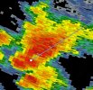
Yep, went outflow-dominant. But it's also bigger now. May be a problem down the road.

Rotation has intensified again. It's actually heading into a local maximum of SRH, so it may get more productive here in the coming hour.Yep, went outflow-dominant. But it's also bigger now. May be a problem down the road.
View attachment 48964

Under a tornado watch now
Ozonelayer
Member


Two little cells near Jackson, AL and Coffeeville. Already got some okay rotation.