
Navigation
Install the app
How to install the app on iOS
Follow along with the video below to see how to install our site as a web app on your home screen.
Note: This feature may not be available in some browsers.
More options
-
Welcome to TalkWeather! We see you lurking around TalkWeather! Take the extra step and join us today to view attachments, see less ads and maybe even join the discussion. CLICK TO JOIN TALKWEATHER
You are using an out of date browser. It may not display this or other websites correctly.
You should upgrade or use an alternative browser.
You should upgrade or use an alternative browser.
Severe WX Severe Weather Threat - Jan 2nd - Jan 4th, 2023
- Thread starter Taylor Campbell
- Start date
ashtonlemleywx
Member

CWASP values from NAM for tmrw afternoon. I think I'm targeting Ark/MS Delta.
Was just looking at that.
CWASP values from NAM for tmrw afternoon. I think I'm targeting Ark/MS Delta.
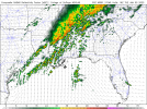
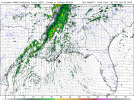
BMX earlier commented on CAMs, esp. the NAM, struggling with convection for Tuesday. Latest run of the NAM continues to hold that precedent, though the 00Z HRRR shows some pretty gnarly convection going on during Tuesday afternoon (see enclosed for NAM and HRRR). A lot to be ironed out on the specifics.
.LONG TERM...
(Monday night through next Saturday)
Issued at 1235 PM CST SUN JAN 1 2023
A complicated forecast scenario to kick off the extended period.
Synoptic guidance is somewhat in agreement deepening a surface low
across the Central Plains on Monday. The attendant upper low will
lift northeast toward the Midwest/western Great Lakes on Tuesday.
The surface low begins to fill with time with the attendant
occluded front approaching the region Tuesday night/early
Wednesday.
As the previous forecast discussions have already mentioned, some
competing factors at play here in terms of precipitation
potential and certainly convection - intensity of convection. We
are getting into the window of the CAMs now and they`re really
struggling with initiating/sustaining convection along or ahead of
the front due to very limited forcing and the dynamics lifting
quickly away from the region.
Dewpoints should recover fairly quickly late Monday into early
Tuesday well into the 60s. And deep layer southerly/southwesterly
flow will lead to effective bulk shear of 40-50 knots. Model
soundings show decent mid level lapse rates with MLCAPE generally
500-1250 J/kg. As such, current feelings are that the CAMs are
undergoing the precip and will trend toward the higher PoPs in
the synoptic and blended guidance. As a caveat, there is some hint
of a potential split in development with one area in the
proximity of the front across our far north/northwest and another
in our south/southeast in the vicinity of the higher theta-e and
moisture transport (with a potential minimum somewhere in the
middle). Did not try to get that cute with the spatial extent for
now given we are still 48 hours out.
The other trend with the 12z guidance has been a slight slowing of
the system - particularly when it comes to the sensible weather. Not
sure I`m ready to fully latch on to that solution just yet but did
maintain fairly high PoPs in the southeast through early Wednesday.
The remainder of the forecast looks fairly benign but generally cool
with the thermal trough lingering across the Tennessee Valley
through at least Friday. Some slow warming by next weekend.
Attachments
ashtonlemleywx
Member

NAM CWASP for Tuesday. I expect this to expand with future runs.
ashtonlemleywx
Member
The NAM tends to struggle with mixing. I usually lean more on the HRRR in this range.BMX earlier commented on CAMs, esp. the NAM, struggling with convection for Tuesday. Latest run of the NAM continues to hold that precedent, though the 00Z HRRR shows some pretty gnarly convection going on during Tuesday afternoon (see enclosed for NAM and HRRR). A lot to be ironed out on the specifics.
Just posted this on my Patreon.
A heavy rain/flash flood as well as severe weather (potentially significant) threat is expected beginning tomorrow and lasting through Tuesday. The 00z HRRR above is from noon tomorrow through 6pm Tuesday evening.
Tomorrow's Threat:
Locations: Arkansas, Louisiana, Texas, western Mississippi, western Tennessee, and southern Missouri.
Storm Timing: 11am Monday thru 4am Tuesday.
Best Timing For Severe Storms: 2pm thru 11pm Monday.
Primary Threats: large hail to golf ball size, damaging winds to 80mph, and tornadoes (few of which could be strong/long tracked).
Highest Severe Storm/Greatest Tornado Risk Area: Northeast Texas, Northwest Louisiana, into Central Arkansas. This includes cities like Little Rock, Arkansas, Shreveport, Louisiana, and Longview, Texas.
Total Rainfall: 2-4 inches with locally higher amounts. Isolated flash flooding possible.
Tuesday's Threat:
Locations: Mississippi, Alabama, southern/central Tennessee, east-central Louisiana, northwest Georgia, and the Florida Panhandle.
Storm Timing: Noon Monday thru 6pm Tuesday evening.
Best Timing For Severe Storms: 3am thru 5pm Tuesday.
Primary Threats: quarter size hail, damaging winds to 70mph, and tornadoes (couple strong/long tracked).
Highest Severe Storm/Greatest Tornado Risk Area: Southern/Central MS, Northeast MS, and Central/Southern Alabama. This includes cities like Jackson, MS, Mobile, Alabama, Birmingham, Alabama, Columbus, MS, Tupelo, MS, and Amory, MS.
Total Rainfall: 2-3 inches with locally higher amounts. Isolated flash flooding possible.
Last edited:
00z 3km NAM at 46 hours.


TH2002
Member
- Messages
- 4,973
- Reaction score
- 11,113
- Location
- California, United States
- Special Affiliations
- SKYWARN® Volunteer
Just curious - what is that one small area just south of the MS/LA border?00z 3km NAM at 46 hours.
View attachment 16365View attachment 16366View attachment 16367View attachment 16368
The circle shape? That is near Norwood, Louisiana and south of Woodville, MS. I'm honestly not sure why it's showing a hole there so to speak.Just curious - what is that one small area just south of the MS/LA border?


ashtonlemleywx
Member
That circle is an anomaly caused by a voodoo witch house in LouisianaJust curious - what is that one small area just south of the MS/LA border?

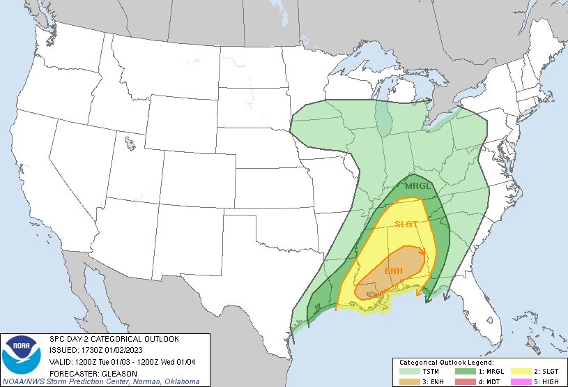
Unfortunately, both days are going to put many of the hardest hit areas from 12/13-14/2022 under the gun once again, but with more of Arkansas and Alabama in play this time.New D2. Enhanced area includes hatched 10% tornado risk.
View attachment 16376
CheeselandSkies
Member
12Z HRRR looks more potent with discrete cellular convection and associated UH tracks across eastern TX/NW LA/SW AR this afternoon/evening compared to previous runs.
TH2002
Member
- Messages
- 4,973
- Reaction score
- 11,113
- Location
- California, United States
- Special Affiliations
- SKYWARN® Volunteer
Should have known... I have a tendency to notice small details while simultaneously overlooking the obvious. Louisiana is a special place!That circle is an anomaly caused by a voodoo witch house in Louisiana
Cbs 42 local station for Birmingham Alabama ; simulated radar tweet. Rather ominous look but, in house weather models do this look a lot. Will be a long day tommorow for Alabama nonetheless. 

Latest D2 brings SLGT eastwards.
..SUMMARY
SEVERE THUNDERSTORMS SHOULD OCCUR TUESDAY ACROSS PARTS OF THE
CENTRAL GULF COAST STATES INTO THE TENNESSEE VALLEY. TORNADOES,
SCATTERED DAMAGING WINDS, AND LARGE HAIL WILL ALL BE POSSIBLE. THE
GREATEST SEVERE-THUNDERSTORM RISK IS EXPECTED FROM SOUTHEAST
LOUISIANA INTO SOUTHERN MISSISSIPPI AND SOUTHERN/CENTRAL ALABAMA,
WHERE STRONG GUSTS AND A COUPLE OF STRONG TORNADOES ARE POSSIBLE.
..CENTRAL GULF COAST STATES INTO THE TENNESSEE/OHIO VALLEYS
A CLOSED UPPER LOW OVER THE CENTRAL PLAINS AND ASSOCIATED MID-LEVEL
SHORTWAVE TROUGH WILL SHIFT EASTWARD TOWARDS THE MID/UPPER MS
VALLEY/GREAT LAKES VICINITY ON TUESDAY. THIS SYSTEM WILL BE
CONTAINED WITHIN A LARGER-SCALE UPPER TROUGH SLOWLY DEVELOPING
EASTWARD ACROSS THE SOUTHERN ROCKIES/SOUTHERN PLAINS. STRONG
DEEP-LAYER SOUTHWESTERLY FLOW WILL PERSIST FROM TX INTO THE OH
VALLEY.
A BROKEN LINE OF CONVECTION WILL BE ONGOING ALONG OR AHEAD OF A COLD
FRONT FROM THE LOWER OH VALLEY INTO NORTHERN MS AND CONTINUING
SOUTHWEST INTO SOUTHEAST TX. STRONGER AND MORE PROGRESSIVE
LARGER-SCALE ASCENT WILL BE FOCUSED OVER NORTHERN PORTIONS OF THE
AREA DURING THE MORNING. UPPER 50S TO LOW 60S F BOUNDARY-LAYER
DEWPOINTS WILL CONTRIBUTE TO WEAK INSTABILITY AMID STRONG SHEAR. AS
A RESULT, SOME OF THIS ACTIVITY MAY BE STRONG TO SEVERE (MAINLY
WIND) FROM PORTIONS OF KY/TN INTO THE NORTHERN MS VICINITY. FURTHER
SOUTH INTO NORTHERN LA AND SOUTHEAST TX, MORE CELLULAR CONVECTION IS
POSSIBLE DURING THE FIRST FEW HOURS OF THE PERIOD.
AHEAD OF THE LARGE-SCALE UPPER TROUGH, A LEAD SHORTWAVE IMPULSE,
WITHIN A SUB-TROPICAL UPPER-LEVEL JET STREAK ORIENTED FROM THE
WESTERN GULF OF MEXICO INTO THE CENTRAL GULF COAST STATES, SHOULD
SERVE AS A FOCUS FOR SEVERE THUNDERSTORM DEVELOPMENT BY LATE TUESDAY
MORNING OR EARLY AFTERNOON ACROSS SOUTHEASTERN LA INTO PARTS OF
SOUTHERN MS/AL. HEIGHT FALLS ACROSS THE AREA WILL REMAIN MODEST
THROUGH THE DAY. HOWEVER, STRONG VERTICAL SHEAR WILL OVERLAP
MID/UPPER 60S F TO PERHAPS LOWER 70S SURFACE DEWPOINTS. VARIOUS
FORECAST SOUNDINGS FROM THE NAM/RAP SHOW WIND PROFILES FAVORABLE FOR
SUPERCELLS AMID 1000-1500+ J/KG MLCAPE. MOST CAMS INDICATE MULTIPLE
SUPERCELLS WILL DEVELOP AHEAD OF THE DECAYING LINE OF CONVECTION
ASSOCIATED WITH THE EASTWARD-PERCOLATING COLD FRONT, AND IN THE
VICINITY OF A MARINE WARM FRONT. THESE DISCRETE SUPERCELLS MAY
PRODUCE A FEW TORNADOES, WITH SOME POSSIBLY STRONG GIVEN A RATHER
FAVORABLE THERMODYNAMIC AND KINEMATIC ENVIRONMENT.
ADDITIONAL CONVECTION IS EXPECTED ALONG THE SURFACE COLD FRONT,
WHICH WILL CREEP EAST/SOUTHEAST THROUGH THE PERIOD, BECOMING
ORIENTED FROM CENTRAL KY/MIDDLE TN TO FAR SOUTHEASTERN LA BY EARLY
WEDNESDAY MORNING. SEVERE POTENTIAL WITH THIS OVERNIGHT ACTIVITY
REMAINS SOMEWHAT UNCERTAIN, AND DEPENDS ON HOW CONVECTION EVOLVES
DURING THE DAY. STILL, IT APPEARS POSSIBLE THAT SOME AREAS ACROSS
THE CENTRAL GULF COAST STATES MAY SEE MORE THAN ONE ROUND OF SEVERE
THUNDERSTORMS TUESDAY INTO TUESDAY NIGHT.
SmokeEater
Member
Meso discussion out for the Arklatex, watch possible, 60%.
Sent from my SM-S901U using Tapatalk
Sent from my SM-S901U using Tapatalk