• Welcome to TalkWeather!
    We see you lurking around TalkWeather! Take the extra step and join us today to view attachments, see less ads and maybe even join the discussion.
    CLICK TO JOIN TALKWEATHER

Severe WX Severe Weather threat for 7/19-7/22/18

Do you think a moderate risk will come out of this threat?

  • Yes

    Votes: 10 45.5%
  • No

    Votes: 5 22.7%
  • An enhanced risk, but not a moderate

    Votes: 6 27.3%
  • It should be a high risk for the wind threat

    Votes: 1 4.5%

  • Total voters
    22
  • Poll closed .
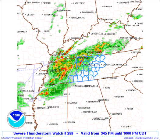
The HRRR suddenly has discrete supercells slated for tonight.. that's a new one.

refcmp_uh001h.us_ov.png
 
I live in Memphis, been kind of cloudy this morning from a line of storms that passed to our west through Arkansas. Thought that might help things, but the suns back out now and it's brutal. Just a short walk outside to refill my dog's water bowl was uncomfortable, putting it mildly. You can definitely feel the charge in the air, if that makes sense..
 
Memphis loves derechos. Been awhile since their last one. Wonder how this one will compare?

There's a lot of uncertainty in this forecast. I expect there to be some surprises today and tomorrow. Question is, will they be good surprises or bad ones?

I am not buying that the derecho will dissipate so quickly after N AL. I expect issues as far south as Clanton. I also think the supercells will form a bit more to the west than currently indicated. This isn't me buying into a particular model solution or variation. It's more about how similar events have evolved in the - - with the obvious caveat that it is July.
 
The 3km NAM is also onboard with at least some cellular activity in N MS / S TN / N AL, and the 16z HRRR is even more aggressive with overnight cellular development.
 
The 3km NAM is also onboard with at least some cellular activity in N MS / S TN / N AL, and the 16z HRRR is even more aggressive with overnight cellular development.

That would be an interesting development pun intended. Also while tornadoes aren't the main weapon in a derecho, the CAMS have been adamant on a powerhouse book end vortex. The NAM earlier had a 1004mb mesolow forming with it as well. That would really back surface winds and raise low level helicity. So be on guard. These things do occasionally produce EF2-EF3 tornadoes in the bookend vortex.
 
3km NAM calls for discrete supercell development in W TN, and HRRR has a few isolated storms, but consistency is a lot lower than we had yesterday
 
Lexington is about to get hammered with straight line winds. Not right next to the radar but the velocities are around 75 mph.
 
Back
Top