Great forecast discussion.
000
FXUS64 KBMX 192359
AFDBMX
Area Forecast Discussion
National Weather Service Birmingham AL
659 PM CDT Thu Jul 19 2018
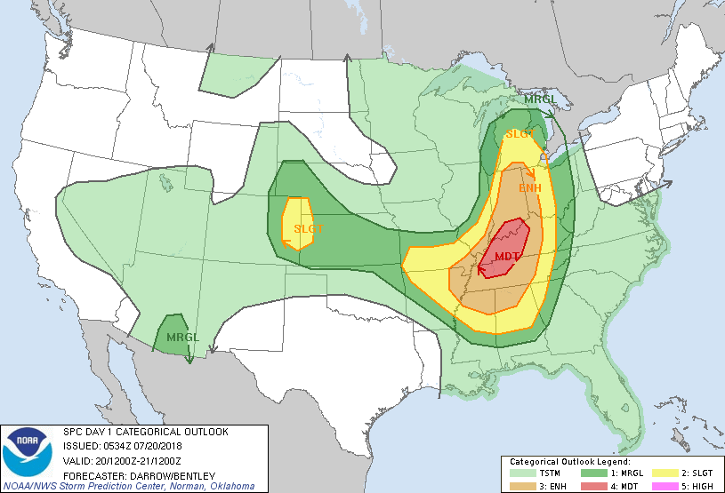
.DISCUSSION...
Updated for severe weather threats on Friday night and Saturday.
An upper-level
trough over the Great Lakes an attendant swath of
northwesterly 40-60kt 500mb
flow will have an unusual impact (for
July) on our forecast area Friday night and Saturday. A synoptic
cold
front located near the Ohio River should be the focus for
explosive
thunderstorm development late Friday afternoon. This
activity should grow upscale in the presence of
SBCAPE values of
4000-6000
J/kg and move southward into TN during the evening. It
appears that relatively lower amounts of
boundary layer moisture
will be present over much of Alabama on Friday afternoon due to
low-level diffluence. This should begin to change during the
evening as the surface to 850mb wind fields respond to the
approaching upper-level
jet streak. A
mesolow associated with the
MCS may also enhance
moisture transport especially across West
Alabama, leading to
SBCAPE values of 3000-4000
J/kg as the
MCS
arrives. This amount of
instability combined with 500mb
flow of
35-45kt should help maintain an enhanced damaging wind into the
northwestern part of the
CWA, and possibly all the way to our
southern border through early Saturday morning. The damaging wind
threat may diminish with eastward extent due to lower
CAPE values.
Another round of severe storms is possible on Saturday if the
airmass recovers. This will depend on the strength and placement
of the
cold pool resulting from the
MCS Friday night into Saturday
morning. Models suggest low-level westerly
flow will become
established Saturday afternoon as 50-55kt northwesterly 500mb
flow
overspreads this area. This may result in quality
moisture
advection and
SBCAPE values of 3500-4500
J/kg. Weak surface
convergence and boundaries leftover from prior
convection could
serve to spark
isolated to
scattered supercell thunderstorm
development Saturday afternoon and evening. In addition to
damaging winds and quarter size
hail, strongly
veering surface to
700mb
flow would support some
tornado risk as well. The overall
setup is highly conditional, and forecast confidence is low at
this time.
87/Grantham

 https://www.weather.gov/hun/hunsurold_july1984microburs