
00z operational GFS is a good bit slower compared to the last several runs... and is more in line with its ensembles and other models. It has this squared up fully on late AM/midday to early evening Thursday over central-east MS, middle TN/KY, much of AL, west GA.
Navigation
Install the app
How to install the app on iOS
Follow along with the video below to see how to install our site as a web app on your home screen.
Note: This feature may not be available in some browsers.
More options
-
Welcome to TalkWeather! We see you lurking around TalkWeather! Take the extra step and join us today to view attachments, see less ads and maybe even join the discussion. CLICK TO JOIN TALKWEATHER
You are using an out of date browser. It may not display this or other websites correctly.
You should upgrade or use an alternative browser.
You should upgrade or use an alternative browser.
Severe WX Severe Weather Threat - February 15-16, 2023
- Thread starter Lake Martin EF4
- Start date
Tim, I would prefer to keep it here for now. Thanks.Matt, would you mind if we could share this research/data with others? I always like to ask first if I can. If you want it kept in here I understand.
Timhsv
Member
Ok, understand. You betTim, I would prefer to keep it here for now. Thanks.
")
Timhsv
Member
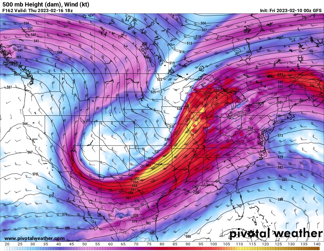
Wow....120knts at 500mb Thursday from this evenings 00Z GF
Bryan C. Wilson
Member
And at last, I'm here for it... LOL00z operational GFS is a good bit slower compared to the last several runs... and is more in line with its ensembles and other models. It has this squared up fully on late AM/midday to early evening Thursday over central-east MS, middle TN/KY, much of AL, west GA.
KevinH
Member
Oh hell00z operational GFS is a good bit slower compared to the last several runs... and is more in line with its ensembles and other models. It has this squared up fully on late AM/midday to early evening Thursday over central-east MS, middle TN/KY, much of AL, west GA.
KevinH
Member
If the latter half of the month is supposed to be very active, it could be less confusing to have a thread for each event (unless we end up with a sequence?).Megathread for the entire Mid-Late Feb period as this appears to be an extremely active period. Will we see 2023's first EF4+ from this? Who knows!
It may be difficult to know which event are referring to in comments if several events are in the same thread (again, unless we end up with a sequence, which would count as one lol)
Not liking what the models have been saying
 Still 6-7 days out soooooooooo I want to see if/when the models flip flop. Y’all know how Dixie behaves…… it doesn’t.
Austin Dawg
Member
Glad to see you. Hate it took a threat, but I like your opinions when I am examining these possible events.00z operational GFS is a good bit slower compared to the last several runs... and is more in line with its ensembles and other models. It has this squared up fully on late AM/midday to early evening Thursday over central-east MS, middle TN/KY, much of AL, west GA.


..Wednesday/Thursday (days 6-7)...
Medium-range models exhibit notable spread in the evolution of a
subsequent upstream mid-level trough forecast to move into the
central states and eventually Great Lakes. However, more
consistency/agreement is becoming evident in the ECMWF/Canadian
operational runs and the ECMWF ensemble mean/GEFS ensemble, with the
operational GFS the outlier. Factors seemingly warranting an
introduction of 15% severe probabilities include the strength of the
model-forecast storm system, and ample time for appreciable
modification of the airmass over the Gulf and Gulf Coast states.
Lol the guys at SPC went and ahead and did it lol. I'm gonna upload bham discussion.
*Nvm, they just mention the possibility of severe no breakdown or anything.
F
Former Member 1430
Guest
I think they should have pulled the trigger. Models are consistent in the idea of a severe outbreak. I feel this one has a high ceiling and could be very bad but we will have to wait and see how models trend over the next few daysLol the guys at SPC went and ahead and did it lol. I'm gonna upload bham discussion.
*Nvm, they just mention the possibility of severe no breakdown or anything.
KevinH
Member
Pulled what trigger?I think they should have pulled the trigger. Models are consistent in the idea of a severe outbreak. I feel this one has a high ceiling and could be very bad but we will have to wait and see how models trend over the next few days
Pulled the trigger on putting a day 7 risk out.Pulled what trigger?
tennessee storm chaser
Member
- Messages
- 1,877
- Reaction score
- 4,288
- Location
- jackson tennessee
- Special Affiliations
- SKYWARN® Volunteer
For spc to highlight a large area perhaps a day earlierPulled what trigger?
KevinH
Member
Oh I read Edith’s comment wrong. I’m thinking “Edith, they DID pull the trigger” lol But Edith was just saying that they agree..Pulled the trigger on putting a day 7 risk out.
I literally just woke up and came straight to these comments. Maybe I’ll go to sleep again SMH ha
Let’s see where things are Monday and Tuesday!
- Moderator
- #96
Lol the guys at SPC went and ahead and did it lol. I'm gonna upload bham discussion.
*Nvm, they just mention the possibility of severe no breakdown or anything.
Hazardous weather outlook for BMX does already have a 1 out of 5 for tornadoes Thursday and mentions tornadoes in the text. This far out, that's significant.
tennessee storm chaser
Member
- Messages
- 1,877
- Reaction score
- 4,288
- Location
- jackson tennessee
- Special Affiliations
- SKYWARN® Volunteer
Memphis already mentions severe weather , but say little far out to go on finer detailsHazardous weather outlook for BMX does already have a 1 out of 5 for tornadoes Thursday and mentions tornadoes in the text. This far out, that's significant.
got Any top analogs from cips on the Time frame?Left: CIPS calculated probability for at least 1 SVR event within 110 km (~70 miles) for period D6-8.
Right: CIPS calculated probability for at least 1 tornado report within 110 km (~70 miles) for period D6-8.


xJownage
Member
One thing i'm noticing is VERY strong advection of dry air into the warm sector. When I first looked at the euro I thought this level of dry air was unreasonable, but there's decent model agreement for just that - see the below gifs.
A strong dry air intrusion aloft would probably be a pretty bad scenario for dixie, considering this dry air will often clean out the warm sector to both foster destabilization and keep storms relatively discrete. In addition, it appears this dry air starts mixing out as it gets to the warm sector, and it's not that hot either, meaning getting a very strong cap out of it doesn't seem highly likely at this time.


A strong dry air intrusion aloft would probably be a pretty bad scenario for dixie, considering this dry air will often clean out the warm sector to both foster destabilization and keep storms relatively discrete. In addition, it appears this dry air starts mixing out as it gets to the warm sector, and it's not that hot either, meaning getting a very strong cap out of it doesn't seem highly likely at this time.