Not at my PC atm, will get you some as soon as I get back.got Any top analogs from cips on the Time frame?
Navigation
Install the app
How to install the app on iOS
Follow along with the video below to see how to install our site as a web app on your home screen.
Note: This feature may not be available in some browsers.
More options
-
Welcome to TalkWeather! We see you lurking around TalkWeather! Take the extra step and join us today to view attachments, see less ads and maybe even join the discussion. CLICK TO JOIN TALKWEATHER
You are using an out of date browser. It may not display this or other websites correctly.
You should upgrade or use an alternative browser.
You should upgrade or use an alternative browser.
Severe WX Severe Weather Threat - February 15-16, 2023
- Thread starter Lake Martin EF4
- Start date
For Day 7, for selected area around BMX/TCL:got Any top analogs from cips on the Time frame?
For NE AL/W-C GA:
For C MS:
Yeah your bigger events in the south have a decent chunk of dry air in the mid levels; or at least from paying attention over the years it does.One thing i'm noticing is VERY strong advection of dry air into the warm sector. When I first looked at the euro I thought this level of dry air was unreasonable, but there's decent model agreement for just that - see the below gifs.
A strong dry air intrusion aloft would probably be a pretty bad scenario for dixie, considering this dry air will often clean out the warm sector to both foster destabilization and keep storms relatively discrete. In addition, it appears this dry air starts mixing out as it gets to the warm sector, and it's not that hot either, meaning getting a very strong cap out of it doesn't seem highly likely at this time.
View attachment 17709
View attachment 17708
Too much and your moisture (instability) won't be able to overcome though, so it's kinda a sweet spot
xJownage
Member
Sometimes, but sometimes they also don't and still happen anyways with a rather messy storm mode. That being said you're right, an EML being advected in is generally a precursor to bigger events.Yeah your bigger events in the south have a decent chunk of dry air in the mid levels; or at least from paying attention over the years it does.
Too much and your moisture won't be able to overcome though, so it's kinda a sweet spot
Another thing to note is that as i said before, this EML isn't that hot and it's mixing out as it arrives in the warm sector, so cap busting really isn't a major failure mode right now.
Also, look further north. KY up into OH and the OH valley gets decent moisture return on the euro. Might be something to watch with regards to the spatial area covered by this potential event, expansion north is absolutely a possibility.
cincywx
Member
Also, look further north. KY up into OH and the OH valley gets decent moisture return on the euro. Might be something to watch with regards to the spatial area covered by this potential event, expansion north is absolutely a possibility.
been watching this for a few days and this has quietly become my concern in cincy. its going to be pushing 70 here next wednesday/thursday as well. still a long ways to go for sure, but events that span this far north/south tend to be very harsh to say the least.
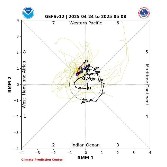
Right on cue, the models are now rapidly speeding us into MJO Phase 8 on the 16th in conjunction with this system. I believe the system itself helps push us into Phase 8.

Updated GFS Ensemble below.

Updated GFS Ensemble below.

xJownage
Member
12Z GFS shows what I was fearing, which is a continued EML uptrend. The GFS seems to be caving to the euro with regards to EML intensity.
Keep posting guys we love y'all's insight @xJownage @Matt Grantham , especially if this becomes a major severe event
CheeselandSkies
Member
12Z GFS is almost TOO far north with the system for this time of year...triple point on the WI/IL border at 18Z 2/16, with low 50s dews along the warm front extending east into southern Lower MI. Kind of insult to injury as a storm enthusiast/chaser if that verifies, since if the upcoming stratospheric PV disruption plays out as expected, we won't be seeing any of those in March and April when they might actually have some teeth around here.
Recently I've seen significant tornado events play out north of 40N much earlier in the season than I thought possible, 3/5 last year and even 2/28/2017. But 2/16?
Recently I've seen significant tornado events play out north of 40N much earlier in the season than I thought possible, 3/5 last year and even 2/28/2017. But 2/16?
xJownage
Member
Don't lump me in with Matt, he's way, way smarter than I'll ever be. I'm just a dumb chaser lol.
Another piece of this GFS run - the trough coming through on tuesday that was going to sweep everything out is continuing to trend north, and it's weakened significantly. This supports my earlier theory of trends pointing towards a northern expansion of the moisture and risk area. Sounding below from central IN on the 12Z GFS reflects this possibility.

Another piece of this GFS run - the trough coming through on tuesday that was going to sweep everything out is continuing to trend north, and it's weakened significantly. This supports my earlier theory of trends pointing towards a northern expansion of the moisture and risk area. Sounding below from central IN on the 12Z GFS reflects this possibility.

warneagle
Member
Yeah the SPC discussion mentioned that there should be plenty of time for the airmass ahead of the trough to modify (at least in the coastal states, not sure about further north). Anytime you get that kind of (relatively) uninterrupted return flow this kind of year that's a big red flag.
F
Former Member 1430
Guest
I agree with your assessment. Way to early yet to say for sure but looks like TN valley, KY, and up to the Ohio River watch out if this trend holds/continuesDon't lump me in with Matt, he's way, way smarter than I'll ever be. I'm just a dumb chaser lol.
Another piece of this GFS run - the trough coming through on tuesday that was going to sweep everything out is continuing to trend north, and it's weakened significantly. This supports my earlier theory of trends pointing towards a northern expansion of the moisture and risk area. Sounding below from central IN on the 12Z GFS reflects this possibility.

tennessee storm chaser
Member
- Messages
- 1,621
- Reaction score
- 3,044
- Location
- jackson tennessee
- Special Affiliations
- SKYWARN® Volunteer
Yeah this one looks like more expanded area in play here …. Lower Ohio valley Down to the central gulf states in the severe risk this timeI agree with your assessment. Way to early yet to say for sure but looks like TN valley, KY, and up to the Ohio River watch out if this trend holds/continues
We may have to watch out for a eventual day 4 or 5 ; 30% risk area if trends continue
KevinH
Member
DittoKeep posting guys we love y'all's insight @xJownage @Matt Grantham , especially if this becomes a major severe event
KevinH
Member
JBishopwx
Member
Posted this on page 1 or 2 in this thread, but remember Brandon/DWX is supposed to be down starting Monday.
GTWXAlum
Member
I wonder if they would possibly postpone in anticipation of some kind of severe event?Posted this on page 1 or 2 in this thread, but remember Brandon/DWX is supposed to be down starting Monday.
- Moderator
- #119
Posted this on page 1 or 2 in this thread, but remember Brandon/DWX is supposed to be down starting Monday.
Yeah, but thankfully with the threat potential being so obvious already and more so on Monday they are likely to postpone maintenance.
Read through his thread. Always good posts by this account

