• Welcome to TalkWeather!
    We see you lurking around TalkWeather! Take the extra step and join us today to view attachments, see less ads and maybe even join the discussion.
    CLICK TO JOIN TALKWEATHER

Severe Weather Threat - December 12-14, 2022

Messages
2,842
Reaction score
4,594
Location
Madison, WI
More recent runs of the GFS are suggesting this system won't pull the warm sector quite as far north as some earlier ones suggested (no repeat of last 12/15). On the other hand, that increases the threat of significant snow across parts of the upper Midwest (possibly including my neighborhood) and may increase the severe threat further south since the main surface low is closer to the richer moisture. It also may be underdoing CAPE across parts of western TN/KY/southern IL and the MO bootheel where dewpoints still get into the upper 50s next Wednesday.
 
Messages
1,062
Reaction score
1,293
Location
jackson tennessee
Special Affiliations
  1. SKYWARN® Volunteer
More recent runs of the GFS are suggesting this system won't pull the warm sector quite as far north as some earlier ones suggested (no repeat of last 12/15). On the other hand, that increases the threat of significant snow across parts of the upper Midwest (possibly including my neighborhood) and may increase the severe threat further south since the main surface low is closer to the richer moisture. It also may be underdoing CAPE across parts of western TN/KY/southern IL and the MO bootheel where dewpoints still get into the upper 50s next Wednesday.
Anxious see the 12z euro today … it’s had better dews getting further north than gfs begin with
 

Fred Gossage

Member
Meteorologist
PerryW Project Supporter
Messages
596
Reaction score
2,096
Location
Florence, AL
GFS has been steadily trending toward the Euro, Canadian, and ICON with the idea of more in the way of wedging and a pinched off warm sector with this system next week after you get east of about I-55 or so. I could see some bit of a surface-based severe weather threat possibly sneaking into southwest Tennessee, but I think Tennessee and Kentucky are mainly looking at heavy rain/possible flooding and mostly non-severe storms with this... and as far as Alabama is concerned, if there is a surface-based severe risk with this Wednesday, I could see it struggling to get as far north as Birmingham (and maybe even Tuscaloosa). Wedging will likely keep north Alabama out of play for any appreciable surface-based severe risk, and it will take wholesale changes on the synoptic scale with both the big upper low in the Plains and the amplitude of the downstream ridging along the East Coast and the digging troughing offshore, and those necessary changes would be very hard to come by with the large scale players on the field. This is synoptic scale wedging and cold air damming driven by low-level high pressure centered in southern Canada and low pressure off the Northeast coast. This is not mesoscale wedging/CAD that is more susceptible to smaller-scale deviations and changes. This wedging looks to sneak as far westward as northeast Mississippi and western Tennessee. High amplitude troughing off the East Coast is not favorable for a quality warm sector east of the Mississippi River.

Having said all that, Tuesday looks kinda mean back over the Arklamiss and then westward through Louisiana, the southern half to 2/3 of Arkansas, and into east Texas and southeast Oklahoma. We will have a more backed mid-level flow this time; so, convective mode won't be as clear cut linear for the majority of the event like it was with a large part of the November 29th outbreak, but if we keep discrete cells for long enough, I could see another event over there that is as mean as the 11/29 event was, if not a bit worse.
 
Messages
2,842
Reaction score
4,594
Location
Madison, WI
Some pretty significant upper diffluence (splitting of the wind barbs) being shown with that trough. As we know, that is an important factor because it promotes lift. However at least on that forecast graphic, it's not exactly the classic super wide-wavelength trough with a slightly more westerly component to the 500mb flow over the warm sector that we usually see with the really high-end outbreaks. I thought the one for the 11/29 setup looked closer to that yet there still ended up being some mitigating factors with regards to storm mode and longevity of warm-sector supercells.
 

Taylor Campbell

Moderator
Moderator
PerryW Project Supporter
Messages
2,111
Reaction score
2,212
Location
Wedowee, AL
Special Affiliations
  1. SKYWARN® Volunteer
The operational GFS/EURO today shows Northeast Texas and the Texarkana region as the focal point for the best threat area on Tuesday. The ensemble members still show a lot of potential differences with time and eastward extent.
 
Last edited:

Tennie

Member
Messages
960
Reaction score
791
Location
Tennessee
SPC dropped the 15% for Monday (D4), kept the 30% for Tuesday (D5), and added in a 15% around the Gulf Coast for Wednesday (D6):

ZCZC SPCSWOD48 ALL
ACUS48 KWNS 091017
SPC AC 091017

Day 4-8 Convective Outlook
NWS Storm Prediction Center Norman OK
0417 AM CST Fri Dec 09 2022

Valid 121200Z - 171200Z

...DISCUSSION...
Medium-range models, and their corresponding ensembles, continue to
depict a scenario fairly consistent with runs over the past couple
of days, with perhaps a slightly slower evolution of the progression
of the substantial upper trough/low. This feature is progged to
move across the Rockies Day 4/Monday, the central Plains Day
5/Tuesday, and then the Mid Missouri Valley Day 6/Wednesday, before
traversing the Midwest/Ohio Valley Day 7 and then the Central
Appalachians Day 8.

Day 4/Monday, as ascent increases across the southern Plains as
suggested by the onset of mid-level height falls, elevated
convection will evolve across the central and into the southern
Plains. Even south of the Red River, storms should remain largely
atop a shallow surface-based stable layer, suggesting that any
severe risk should be in the form of hail, and appearing
insufficient at this time to continue with the 15% risk area.

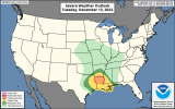
Day 5/Tuesday, progression of the front across the southern Plains
will occur, reaching the Ozarks/Arklatex/East Texas area by early
evening. Ahead of the front, strong southerly winds will advect
seasonably rich Gulf moisture northward, likely resulting in
sufficient instability for the development of severe/supercell
storms. At this time, the greatest risk remains apparent from
roughly the Arklatex region eastward straddling the
Arkansas/Louisiana border, where very strong/veering flow with
height should combine with ample CAPE to yield all-hazards severe
risk, including tornado potential.

Severe risk will likely continue overnight and into Day 6/Wednesday,
though a persistent antecedent surface high/cold air damming into
the southern Appalachians should suppress instability -- and thus
severe potential -- progressively farther southward as storms shift
eastward across the Gulf Coast states through the day. Still,
all-hazards severe risk is apparent across southern parts of
Mississippi and Alabama, and into the Florida Panhandle overnight,
warranting inclusion of a 15% area for Day 6.

Day 7/Thursday, persistence of the damming high should continue to
suppress instability southward. While some severe risk could
locally evolve across the Florida Peninsula, potential appears too
low to warrant areal inclusion.

With the front currently expected to move offshore overnight
Thursday or early Friday, severe weather potential should shift away
from the mainland.

..Goss.. 12/09/2022
 
Messages
2,842
Reaction score
4,594
Location
Madison, WI
GFS seems to have downtrended a bit with instability and thus composite parameters on the forecast soundings (EHI, STP, etc). However, check out this NAM hodograph (and accompanying SRH values) for southwest MS on Tuesday evening:
 

Attachments

  • nam_2022121012_084_31.57--90.48.png
    nam_2022121012_084_31.57--90.48.png
    238.3 KB · Views: 0

JBishopwx

Member
Sustaining Member
Messages
890
Reaction score
1,995
Location
Ackerman, MS
Special Affiliations
  1. SKYWARN® Volunteer
15971_f7212f681d487ef5a482bd4a30c6f4d5.png
1000001528.png
 

Attachments

  • 1000001526.png
    1000001526.png
    322.5 KB · Views: 0

JPWX

Member
Messages
1,499
Reaction score
4,050
Location
Smithville MS
Updated Day 2 Outlook. Expansion of Marginal and Slight Risk areas into more of North MS/West Tennessee. I can definitely see where all of central and north MS gets put under a Slight Risk. Along with the Marginal Risk getting into parts of western Alabama and the Enhanced Risk being extended east to south of Jackson and up to Vicksburg.MS_swody2 (14).pngMS_swody2_TORN.png
 
Back
Top