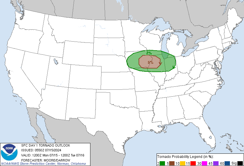
Strong long-track tornadoes will be likely from parts of central and southern Kansas southward into western Oklahoma.
...Tornado Outbreak Likely Across Parts of the Southern and Central
Plains Today and Tonight...
...Southern and Central Plains...
An upper-level low will move eastward across the Four Corners region
and central Rockies today as a lead shortwave rotates around the
southeastern side of the system into the southern and central
Plains. At the surface, a very moist airmass will advect northward
across Oklahoma into southern and central Kansas with surface
dewpoints reaching the mid 60s to lower 70s by afternoon. Strong
instability should be in place to the east of a well-developed
dryline situated from just east of Dodge City southward across far
western Oklahoma by mid-afternoon. Thunderstorms are forecast to
initiate rapidly during the mid to late afternoon along the dryline
with numerous severe thunderstorms moving east-northeastward across
the southern and central Plains during the late afternoon and early
evening. A very moist airmass, strongly unstable warm sector,
favorable deep-layer shear and impressive low-level shear appears
likely for a tornado outbreak from central and southern Kansas
southward across western Oklahoma.
At this time, surface maps show a very moist airmass across the
eastern third of Texas with lower to mid 70s F dewpoints at most
observation sites. This airmass is advecting northward quickly and
appears certain to overspread the moderate and high risk areas by
this afternoon. Deterministic and hi-res solutions suggest that a
strongly unstable airmass will be in place by afternoon with MLCAPE
values reaching the 3000 to 4000 J/kg range. In addition, the exit
region of a 45 to 60 kt mid-level jet is forecast to be located
across northwest Oklahoma and south-central Kansas by late afternoon
which will create strong deep-layer shear profiles over the top of a
pristine airmass. NAM forecast soundings late this afternoon show
0-6 km shear in the 50 to 60 kt range to the east of the dryline
with gradually veering winds with height in the low to mid-levels.
This wind profile will support discrete supercell formation. Backed
surface winds to the southeast, strong speed shear in the boundary
layer and a strengthening 40 to 50 kt low-level jet will be very
favorable for tornadoes. Low-level shear is forecast to increase
during the early evening with 0-3 km storm-relative helicities
reaching the 350 to 450 m2/s2 range across the moderate and high
risk areas. This will be favorable for strong tornadoes with several
long track tornadoes moving across the high risk and moderate risk
areas. High-end tornadoes will also be possible across the high risk
area. Forecast soundings also show very steep 700 to 500 mb lapse
rates of 8.0 C/km. This combined with the strong deep-layer shear
will make large hail likely with supercells. The more intense
supercells will likely produce hailstones of greater than 2 inches
in diameter. By late evening, MCS formation should take place as
several severe storm clusters move eastward across northern Oklahoma
and eastern Kansas. Some tornadoes along with large hail and wind
damage should be associated with this MCS.