Kory
Member
The push toward centralization is not a good one. What is the point of local offices then?I bet that is very annoying for you guys.
Follow along with the video below to see how to install our site as a web app on your home screen.
Note: This feature may not be available in some browsers.
The push toward centralization is not a good one. What is the point of local offices then?I bet that is very annoying for you guys.
yeah, there seems to be a lot of uncertainty. I have doubts about the northward extent of the CAPE.We have to closely match SPC now. So it's essentially the D2 outlook. I'm not buying the hype right now.
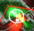
Am I seeing a horizontal vortex tube near the bottom left?Picture of the tornado as it was near/in Alexandria, LA. Credit to twitter user @Lucas_Wiseman
View attachment 166

Can you link us to that stream?Power flashes on John Humpress' stream, Rapides County. Interesting since the storm doesn't look that impressive on radar.
http://www.severestudios.com/storm-chasers/john.humphress.htmlCan you link us to that stream?
Here you go:Can you link us to that stream?