• Welcome to TalkWeather!
    We see you lurking around TalkWeather! Take the extra step and join us today to view attachments, see less ads and maybe even join the discussion.
    CLICK TO JOIN TALKWEATHER
  • April 2024 Weather Video of the Month
    Post your nominations now!

Severe WX Severe Weather Threat 4/2/17-4/3/17

Bama Ravens

Member
Messages
1,210
Reaction score
656
Location
Morris, AL (Northern Jefferson County)
HRRR has the line coming through Birmingham around 6am tomorrow morning.

refcmp.us_se.png
 
Messages
604
Reaction score
429
Location
St. Catharines, Ontario
Well, it's just about completely reorganized into a squall line now.
Interesting that the SPC is still only reporting 6 tornadoes, mostly from this morning, but radar indicated rotation has suggested around 15-25 so far. I wonder why they're so far behind with the reports.
 

WesL

"Bill, I'm talkin' imminent rueage"
Staff member
Administrator
Moderator
Sustaining Member
Messages
3,384
Reaction score
2,695
Location
Fayetteville, AR
Special Affiliations
  1. SKYWARN® Volunteer
Impressive view from GOES 16 via IR. Just wow.


andyhb

Member
Meteorologist
Messages
1,161
Reaction score
3,309
Location
Norman, OK
Well, it's just about completely reorganized into a squall line now.
Interesting that the SPC is still only reporting 6 tornadoes, mostly from this morning, but radar indicated rotation has suggested around 15-25 so far. I wonder why they're so far behind with the reports.
Severe weather ops take up a lot of time in the heat of the event, recording LSRs are generally put on low priority until the event is over.
 

WesL

"Bill, I'm talkin' imminent rueage"
Staff member
Administrator
Moderator
Sustaining Member
Messages
3,384
Reaction score
2,695
Location
Fayetteville, AR
Special Affiliations
  1. SKYWARN® Volunteer
Listening to Vicksburg area scanner reports of multiple flood related rescues including one officer that was caught up in rising water.
 

Tyler Penland

Mountain Snow Miser
Staff member
Moderator
Messages
254
Reaction score
154
Location
Blowing Rock, NC; Elevation 3,575ft
SWS from FFC regarding tomorrow.
...Widespread Severe Storms Likely Monday...

A potent weather system is expected move out of the lower
Mississippi River valley tonight and into the local area through
Monday. All of North and Central Georgia will be affected by this
system with damaging winds...tornadoes and large hail the primary
hazards.

Timing...Storms will move into portions of West Central and North
Georgia including the Atlanta metro between 11am and 2pm and last
for several hours. For areas from Columbus to Macon...we can
expect the activity between 1pm and 4pm and finally Abbeville to
Dublin between 3pm and 7pm. These time periods are subject to
change slightly based on later guidance.

Hazards...

Damaging winds...A line of severe storms will push through the
area with damaging winds of 60 to 80 mph the primary threat. This
will down trees and powerlines in the storms path and precautions
should be made now to secure any light outdoor objects like lawn
furniture.

Tornadoes...Ahead of the main line...individual storms are likely
to develop...especially over west central portions including the
Columbus area. There is a risk for long track tornadoes of EF2
intensity or greater with these storms.

Hail...Hail as large as an inch and a half will be possible with
these storms as well...especially south of the I20 corridor.

Please take this time ahead of the storms to review your severe
weather plan and make sure your NOAA weather radio is operational.
 

Kory

Member
Messages
4,928
Reaction score
2,119
Location
Tuscaloosa, Alabama
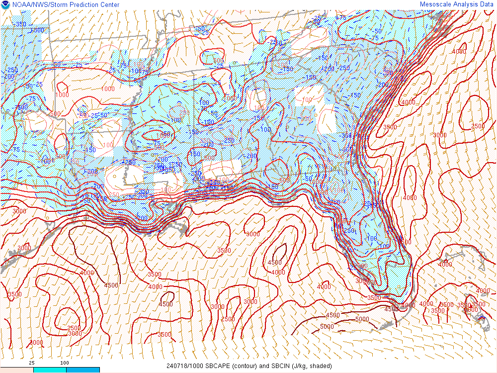
BMX is doing a live update on Periscope. They feel that the rain in MS is spreading eastward faster than anticipated. If it moves in, it obviously could impact the advection of higher CAPE values.
It's actually several hours ahead of projections. Might actually allow for better thermo recovery tomorrow afternoon behind the MCS (assuming it gets out in time and doesn't stall).

If we can get better recovery behind for tomorrow, maybe some isolated severe storms tomorrow afternoon IF we can get convection to fire. These MCS's are woeful to forecast.
 

Bama Ravens

Member
Messages
1,210
Reaction score
656
Location
Morris, AL (Northern Jefferson County)
It's actually several hours ahead of projections. Might actually allow for better thermo recovery tomorrow afternoon behind the MCS (assuming it gets out in time and doesn't stall).

If we can get better recovery behind for tomorrow, maybe some isolated severe storms tomorrow afternoon IF we can get convection to fire. These MCS's are woeful to forecast.
Satterwhite says that they think the steady rain behind the line will last long enough that they do not expect much redevelopment behind the line.
 

Psalm 148:8

Member
Messages
56
Reaction score
25
Location
West central GA
Praying we can scrape by tomorrow....Wednesday gas my greatest attention...but at this time I hear that the global models still not at a concensus.
 

Kory

Member
Messages
4,928
Reaction score
2,119
Location
Tuscaloosa, Alabama
Some pretty heavy totals coming out of West LA over a foot of rain. Classic upper level jet splitting leading to enhanced divergence and a stalled trailing end of a MCS....

Won't surprise me for some places to see 18"....
 

MattW

Member
Messages
316
Reaction score
217
Location
Decatur, GA
HAM Callsign
KG4GUF
Special Affiliations
  1. SKYWARN® Volunteer
NAM 3km has trended slightly more north for Atlanta over the last two runs. Also about an hour or so faster, does seem to limit things a tad.
 
Back
Top