• Welcome to TalkWeather!
    We see you lurking around TalkWeather! Take the extra step and join us today to view attachments, see less ads and maybe even join the discussion.
    CLICK TO JOIN TALKWEATHER
Logo 468x120

Severe WX Severe Weather Threat 4/2/17-4/3/17

Messages
148
Reaction score
210
Location
Trussville
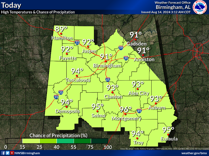
This looks to be a heavy rain, and wind event. With the HRRR having it come in earlier then most thought, could just get trough with a windy morning, with a few possible severe thunderstorm warning. Can't rule out a tornado warning, but this looks way to messy. I am speaking for central Alabama of course, but even further south where the mdt risk is, it could be scaled back some, maybe even go back to enhanced.
 
Messages
472
Reaction score
441
Location
Canton, GA
HRRR, other guidance, and radar trends seem to be on schedule for us folks further East. Unless something crazy occurs, still thinking the line will intensify over Central and North Central GA. Isolated cells look to develop ahead of the line over East Georgia and the Piedmont of South Carolina. Should be an interesting event.
 
Last edited:
Messages
179
Reaction score
59
Location
Adel, Ga
Lots of schools around here releasing at Noon including Daleville and Dothan. HRRR and NAM 3k both would say good call if they want the kids to leave just in time to play in the rain and get soaked on the trip home!

refcmp.us_se.png
 

Equus

Member
Messages
3,295
Reaction score
3,380
Location
Jasper, AL
Special Affiliations
  1. SKYWARN® Volunteer
Day one outlook at 6z has dropped the moderate and put in an enhanced as the highest category. Tor probs at 5%. Not the only recent day two to day one moderate downgrade recently if I recall.
 

Timbo64

Member
Messages
31
Reaction score
41
Location
Decatur, Al
https://www.facebook.com/pg/BradTravisWAFF48/videos
In the video "Locally heavy rain Monday FB live on a Sunday night" (starting at 15:20 in the video)
Brad talks about how the SPC Outlooks have been under-performing lately and the problems that's causing.
Brad: "When you issue a day 2 moderate risk and then, within 12 hours, you're down to a general thunderstorm forecast it's really a problem because that's who the school systems are getting their information from."
 
Last edited by a moderator:

Bama Ravens

Member
Messages
1,210
Reaction score
656
Location
Morris, AL (Northern Jefferson County)
image2.png
 

pritchlaw

Member
Messages
87
Reaction score
108
Location
Warrior, AL
This is becoming so common. 2 days out the risks are forecast too high, have to be scaled back once the event is almost happening. The SPC is losing credibility on their forecasts on these things with me. By the time they adjust it, the event is so close, or even already occurring, that anyone could have come up with their analysis. I'd hate to see them go all Weather Channel and just be slinging out sensationalism every time there's model spitting out some significant event that is likely not going to materialize.
 
Messages
472
Reaction score
441
Location
Canton, GA
So much for chasing anything today.
If you're feeling adventurous, and want to chase the rolling beauty of East Georgia, head over to Athens. You should see semi discrete convection begin to mature after noon. Central Georgia into the Piedmont/Sandhills of SC has always had the "higher" tornado potential for today.
 

Equus

Member
Messages
3,295
Reaction score
3,380
Location
Jasper, AL
Special Affiliations
  1. SKYWARN® Volunteer
Lot of TOR popping along the line from GA all the way to the FL panhandle. None look impressive. Am I missing something, or perhaps they were short lived spin ups that I missed on radar by a frame or two?
 
Messages
472
Reaction score
441
Location
Canton, GA
Lot of TOR popping along the line from GA all the way to the FL panhandle. None look impressive. Am I missing something, or perhaps they were short lived spin ups that I missed on radar by a frame or two?
Several mid level circulations have developed within the line. The Carroll and Paulding cells have shown tightening low level rotation at times, thus the warnings. The Carroll cell has really broadened.
 

Equus

Member
Messages
3,295
Reaction score
3,380
Location
Jasper, AL
Special Affiliations
  1. SKYWARN® Volunteer
Ah, ok. Thanks. I was only checking the low level scans.

If there's a tornado in the Ozark storm, it might legitimately hit KEOX in a couple moments. Let's hope not
 

Equus

Member
Messages
3,295
Reaction score
3,380
Location
Jasper, AL
Special Affiliations
  1. SKYWARN® Volunteer
Shades of 1/22, that. Going the HTX route of loving clear air mode but hiding scared of storms I guess.

Is it just me or is part of the line breaking into segments? Could be an interesting day
 
Back
Top