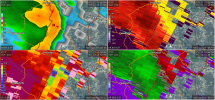
QLCS looks rather impressive off KJGX with several embedded supercells apparent. Storms developing ahead of the line may also intensify as per SPC watch and preceding MD. *May* be a TDS associated with the middle storm SW of Sandersville.
Regarding yesterday's event, I still have yet to see much in the way of damage reports from the most impressive real-time tornadic radar signature of the day, the Jena area storm, other than one "wind damage" report out of Midway.
It sounds like the towns lucked out, to the extent of escaping violent tornado damage, but I have to believe it was on the ground for some time and hit at least a few structures in/near the Fellowship community south/southwest of Jena and Midway. The TDS was massive for several scans.
*Edit: As I typed, that middle QLCS storm got a TORR for "radar confirmed," and one of the cells out ahead of it went tornado warned.