Radar indicated Tornado Warning in South Dakota;
683
WFUS53 KFSD 152208
TORFSD
SDC015-023-053-152245-
/O.NEW.KFSD.TO.W.0004.250715T2208Z-250715T2245Z/
BULLETIN - EAS ACTIVATION REQUESTED
Tornado Warning
National Weather Service Sioux Falls SD
508 PM CDT Tue Jul 15 2025
The National Weather Service in Sioux Falls has issued a
* Tornado Warning for...
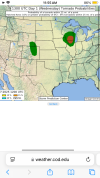
Northwestern Charles Mix County in south central South Dakota...
North central Gregory County in south central South Dakota...
South central Brule County in south central South Dakota...
* Until 545 PM CDT.
* At 508 PM CDT, a severe thunderstorm capable of producing a tornado
was located 10 miles east of Iona, or 15 miles south of
Chamberlain, moving southeast at 20 mph.
HAZARD...Tornado and quarter size hail.
SOURCE...Radar indicated rotation.
IMPACT...Flying debris will be dangerous to those caught without
shelter. Mobile homes will be damaged or destroyed.
Damage to roofs, windows, and vehicles will occur. Tree
damage is likely.
* This tornadic thunderstorm will remain over mainly rural areas of
northwestern Charles Mix, north central Gregory and south central
Brule Counties.
PRECAUTIONARY/PREPAREDNESS ACTIONS...
TAKE COVER NOW! Move to a basement or an interior room on the lowest
floor of a sturdy building. Avoid windows. If you are outdoors, in a
mobile home, or in a vehicle, move to the closest substantial shelter
and protect yourself from flying debris.
&&
LAT...LON 4365 9921 4352 9894 4336 9917 4351 9929
4353 9928 4355 9932 4358 9934
TIME...MOT...LOC 2208Z 319DEG 16KT 4357 9922
TORNADO...RADAR INDICATED
MAX HAIL SIZE...1.00 IN


.jpeg?width=1200&height=800&crop=1200:800)