
KakashiHatake2000
Member
Follow along with the video below to see how to install our site as a web app on your home screen.
Note: This feature may not be available in some browsers.
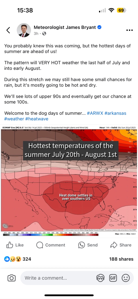
Feel that @Brice W have family from out of state that always visit in August. Always, like why??? lol. My whole demeanor changes in hot humidity so I am not sociable. I think ONE time in ten years it was 15% humidity and I was like hey yall! lolAugust typically is our hottest time of year. And the most humid too.
gotcha brice and oh how fun with august being your hottest and most humid time of the year

View attachment 45051
looks to be a true fire tornado , with a mesocyclone / wall cloud.
the rotation in the likely pryocumulonimbus is pretty intense as well.
View attachment 45052
later part shows again , wall cloud , and 2 tornadoes , with a inflow tail and a horizontal vortex at the top of the wall cloud
For an event that absolutely hit their ceiling, my vote would be 5/16.What do y’all think the most overpreforming and underperforming outbreaks this year were? For me it’d have to be 3/14 and 4/28.
Somebody in this forum said a while back that March 14 would have likely verified a 60% hatched, although I’m not sure if that’s 100% true.For an event that absolutely hit their ceiling, my vote would be 5/16.
I’m going to be honest, 4/2 actually surpassed my expectations. I was genuinely confused and didn’t initially understand why Broyles went with a high risk. There was so much uncertainty at play, but once those supercells started cranking and everything came together, my god. The Lake City, AR tornado had some of the most violent motion i’ve ever seen and I have absolutely little doubt it was a lot more violent than the rating it was given.What do y’all think the most overpreforming and underperforming outbreaks this year were? For me it’d have to be 3/14 and 4/28.
Lake City is easily up there on my list of top 5 best-looking tornadoes of 2025; the Tuscaloosa-esque vortex as it neared town is only very rarely seen (last time I can recall that happening on video was from the Jonesboro EF3 in 2020).I’m going to be honest, 4/2 actually surpassed my expectations. I was genuinely confused and didn’t initially understand why Broyles went with a high risk. There was so much uncertainty at play, but once those supercells started cranking and everything came together, my god. The Lake City, AR tornado had some of the most violent motion i’ve ever seen and I have absolutely little doubt it was a lot more violent than the rating it was given.
It’s also one of the most underrated tornadoes. It produced clear cur EF4 contextuals, and was slapped with a high end EF3 rating. I do remember the house that was mostly slabbed in that area wasn’t horribly built and had intense contextual damage around in and imo, that should have been enough for an EF4 rating. But you know, MEG…Lake City is easily up there on my list of top 5 best-looking tornadoes of 2025; the Tuscaloosa-esque vortex as it neared town is only very rarely seen (last time I can recall that happening on video was from the Jonesboro EF3 in 2020).
Oh, 100%. My top 5 “best-looking” this year:It’s also one of the most underrated tornadoes. It produced clear cur EF4 contextuals, and was slapped with a high end EF3 rating. I do remember the house that was mostly slabbed in that area wasn’t horribly built and had intense contextual damage around in and imo, that should have been enough for an EF4 rating. But you know, MEG…
