
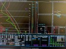
Hrrr has a small enhanced localized zone of higher tornado probs in west Alabama tommorowYea a friend sent me a TOR sounding from south of Columbus MS for tmrw from latest HRRR.
Had some juicy 3000+ CAPE but wind shear profile wasn't impressive.
Navigation
Install the app
How to install the app on iOS
Follow along with the video below to see how to install our site as a web app on your home screen.
Note: This feature may not be available in some browsers.
More options
-
Welcome to TalkWeather! We see you lurking around TalkWeather! Take the extra step and join us today to view attachments, see less ads and maybe even join the discussion. CLICK TO JOIN TALKWEATHER
You are using an out of date browser. It may not display this or other websites correctly.
You should upgrade or use an alternative browser.
You should upgrade or use an alternative browser.
Severe Weather 2023
- Thread starter KevinH
- Start date
CC: @StanD_WXYea a friend sent me a TOR sounding from south of Columbus MS for tmrw from latest HRRR.
Had some juicy 3000+ CAPE but wind shear profile wasn't impressive.
Attachments
Don't be surprised if a 5% tornado risk for portions of east missippi and west Alabama gets issued. You'll likely have a localized higher risk with any discrete or semi discrete convection or a spin up along the MCS.

The weak low pressure really backs winds and increases localized shear. Pretty sneaky threat. ESPECIALLY if a cell or two initiates near the frontal boundary almost near where a prototypical triple point would be12Z HRRR UH for tomorrow. Weird little super-localized threat on MS/AL border tomorrow. Small areal coverage and tiny temporal window.
View attachment 18647

 see
seeMay have a boundary of some sort layed down by today's storms as well.
3km cape at 200? In that localized enhanced zone tommorow. Not sure why many people arent talking about this pseudo frontal storms tommorow.
If cells fire along that boundary s environment exists for a decent potential for a tornado threat.
If cells fire along that boundary s environment exists for a decent potential for a tornado threat.
Jackson regaring Sunday:
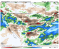
While still some five days out, models are coming into better agreement with severe parameters being favorable for some robust convection over portions of the forecast area Sunday afternoon. With sufficient deep-layer wind shear (45-55 knots 0-6 km), adequate instability as CAPE values hover around 1500 J/KG, steep mid-level lapse rates (6.5-8 C/km 700-500 MB with 27-29 vertical totals), and overall good forcing, and confidence is increasing that a portion of the CWA could be outlooked for the potential for at least isolated severe storms on Sunday. Once again, this is still several days away, and changes in model data, either supporting or against any severe threat, are expected.
Saturday and Sunday:


GFS Extended Control, Euro Weeklies Mean, and Euro Weeklies Control 35 to 46 day precipitation anomalies. You can forget about a drought across the Mid-South/Southeast region. The Mississippi River might be flooding by late Spring.
Attachments
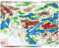
Updated Risk Areas for Saturday/Sunday:


Looks like a damaging e
Wind/ hail event from a quick look and see a elongated low pressure
Hodograph for south Alabama on Sunday 
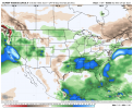
Nothing over-the-top for March but could definitely cause a few issues in AL and MS. Wind fields are pretty wonky-looking in C and N AL. Classic GA wedge seems to keep ATL metro northward out of the action, so hopefully that holds, though SPC has virtually all of MS/AL/GA under at least a marginal risk.


I think for any substantial tornado risk to appear would be if a mesolow of something to back winds more becomes evident. Surface winds are almost parallel to the elongated low veering them pretty good; severely hindering any substantial tornado risk. Maybe a very isolated spin up though.Nothing over-the-top for March but could definitely cause a few issues in AL and MS. Wind fields are pretty wonky-looking in C and N AL. Classic GA wedge seems to keep ATL metro northward out of the action, so hopefully that holds, though SPC has virtually all of MS/AL/GA under at least a marginal risk.
View attachment 18671View attachment 18670
I think it's a interesting thing. Gulf temperates are pretty high already. This will fuel mositure moving forward this spring.
- Moderator
- #478
Thread for weekend severe weather threat https://talkweather.com/threads/severe-weather-threat-march-11th-12th-2023.2095/#post-89034.
SPC is already hinting at next weekend too
- Thread starter
- #480
KevinH
Member
Classic Georgia wedge?Nothing over-the-top for March but could definitely cause a few issues in AL and MS. Wind fields are pretty wonky-looking in C and N AL. Classic GA wedge seems to keep ATL metro northward out of the action, so hopefully that holds, though SPC has virtually all of MS/AL/GA under at least a marginal risk.
View attachment 18671View attachment 18670