
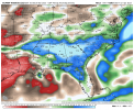
NWS Jackson mentioning the potential for an MCS during the mid thru late week timeframe.
Navigation
Install the app
How to install the app on iOS
Follow along with the video below to see how to install our site as a web app on your home screen.
Note: This feature may not be available in some browsers.
More options
-
Welcome to TalkWeather! We see you lurking around TalkWeather! Take the extra step and join us today to view attachments, see less ads and maybe even join the discussion. CLICK TO JOIN TALKWEATHER
You are using an out of date browser. It may not display this or other websites correctly.
You should upgrade or use an alternative browser.
You should upgrade or use an alternative browser.
Severe Weather 2023
- Thread starter KevinH
- Start date
CheeselandSkies
Member
Latest from SPC...
...D6/Saturday - D7/Sunday: Southern Plains into the Southeast...
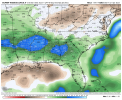
The 06/00Z ECMWF, GFS, and CMC have all trended toward a greater
potential severe-thunderstorm threat next weekend. In general, these
solutions show a surface low intensifying across the central High
Plains on Saturday, and then propagating east-southeastward along
the remnant front (from the previous system) across the southern
Plains and eventually into the Southeast on Sunday. As this occurs,
a notable EML overspreads seasonably rich low-level moisture, with
favorable buoyancy and deep-layer shear supporting organized
thunderstorm development along the remnant boundary and a trailing
cold front.
However, the above scenario represents a significant change from
previous ECMWF/GFS/CMC deterministic runs, with considerable spread
noted amongst global ensemble members. If extended-range guidance
shows consistency with this scenario going forward, then severe
probabilities will eventually be needed, but predictability remains
too low to introduce any 15% areas with this outlook.
..Dean.. 03/06/2023
- Thread starter
- #423
KevinH
Member
SMHLatest from SPC...
Well I don’t think *I* will be the one to start the thread this time lol
We are within range per the existing thread policy, but this far out, I would not want to start a thread until/unless we get a risk area highlighted by the SPC.
Until we get to D3, I am not putting a whole lot of emphasis on the models UNLESS every last one of them have considerable agreement on an event D4-8. Too many variables can cause too many outcomes that can change.
Just me…
Last edited:
Well since KGWX radar is down for 10 to 12 days for upgrades, then a severe weather risk can be expected. LOL!
CheeselandSkies
Member
SMH
Well I don’t think *I* will be the one to start the thread this time lol
We are within range per the existing thread policy, but this far out, I would not want to start a thread until/unless we get a risk area highlighted by the SPC.
Until we get to D3, I am not putting a whole lot of emphasis on the models UNLESS every last one of them have considerable agreement on an event D4-8. Too many variables can cause too many outcomes that can change.
Just me…
Case in point, the 12Z GFS came in with a totally different look for next weekend, with the system coming through on Friday before the moisture really has a chance to load up.
18Z GFS has a possible risk for parts of the South both Friday and again Sunday, but neither looks particularly high-end.
- Thread starter
- #426
KevinH
Member
Right on cue… shocker lolWell since KGWX radar is down for 10 to 12 days for upgrades, then a severe weather risk can be expected. LOL!
- Thread starter
- #427
KevinH
Member
Just wait…. I am sure the flip flopping will begin shortly lolCase in point, the 12Z GFS came in with a totally different look for next weekend, with the system coming through on Friday before the moisture really has a chance to load up.
18Z GFS has a possible risk for parts of the South both Friday and again Sunday, but neither looks particularly high-end.
CheeselandSkies
Member
Just wait…. I am sure the flip flopping will begin shortly lol
It already has!
tennessee storm chaser
Member
- Messages
- 1,877
- Reaction score
- 4,288
- Location
- jackson tennessee
- Special Affiliations
- SKYWARN® Volunteer
Any system coming perhaps over the next week and half at least will have a hard time with quality moisture return.. we maybe fixiingngetn a week to two weeks break severe weather wise until things fire back up by end of March ….. April could be shaping Up to be a violent month if the teleconnections line up like am seeing
- Thread starter
- #430
KevinH
Member
Any system coming perhaps over the next week and half at least will have a hard time with quality moisture return.. we maybe fixiingngetn a week to two weeks break severe weather wise until things fire back up by end of March ….. April could be shaping Up to be a violent month if the teleconnections line up like am seeing
Apparently April is (severe weather) violence awareness month.
If the Euro Weeklies are correct, not only will be dealing with additional severe weather potential, but a flooding risk as well going into April. Looks like a wet Spring ahead.
Attachments
- Thread starter
- #432
KevinH
Member
**IF**If the Euro Weeklies are correct, not only will be dealing with additional severe weather potential, but a flooding risk as well going into April. Looks like a wet Spring ahead.
- Moderator
- #433
The thermal profile looks well on the models and the GFS point soundings. We increase shear and the threat ramps up quickly for Sunday.
Last edited:
- Thread starter
- #434
KevinH
Member

If we turn off all the radars at once I'm pretty sure we would summon some kind of tornadic deity.Oh look well would you look at that…
Let me guess, this upgrade JUST HAPPENS to coincide with an upcoming potential event? Why do they (consistently???) perform these upgrades IN THE SPRING?!?!?
These were schedule at least a year in advance. The way I understand, the local NWS did not schedule these.Oh look well would you look at that…
Let me guess, this upgrade JUST HAPPENS to coincide with an upcoming potential event? Why do they (consistently???) perform these upgrades IN THE SPRING?!?!?
Looks like the much bigger update will happen in June.
https://www.roc.noaa.gov/wsr88d/PublicDocs/SLEP/Pedestal-SLEP-Update-02-21-23.pdf and https://www.roc.noaa.gov/wsr88d/PublicDocs/SLEP/Generator-Schedule-Update-02-21-23.pdf
Well as long as KGWX is back up before April.
Joke with Matt that they should go ahead and cut the trees that were blocking the radar while it was down.Well as long as KGWX is back up before April.
Looks like his video will be out today.
tennessee storm chaser
Member
- Messages
- 1,877
- Reaction score
- 4,288
- Location
- jackson tennessee
- Special Affiliations
- SKYWARN® Volunteer
Looks like his video will be out today.
Can’t wait see it … I be willing bet hundred bucks april 74 is one analogs