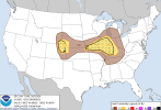
• Welcome to TalkWeather!
    We see you lurking around TalkWeather! Take the extra step and join us today to view attachments, see less ads and maybe even join the discussion.
    CLICK TO JOIN TALKWEATHER

Severe Weather 2023

Todays tornado threat seems to have shifted slightly south to SE IL / SW IN / NW KY. Also have a hatched moderate risk for wind, and hatched slight risk for hail. Enhanced risk overall.


Attachments

  • Screen Shot 2023-06-29 at 11.16.20 AM.png
    Screen Shot 2023-06-29 at 11.16.20 AM.png
    975.1 KB · Views: 0
  • Screen Shot 2023-06-29 at 11.16.25 AM.png
    Screen Shot 2023-06-29 at 11.16.25 AM.png
    793.9 KB · Views: 0
  • Screen Shot 2023-06-29 at 11.16.35 AM.png
    Screen Shot 2023-06-29 at 11.16.35 AM.png
    889.6 KB · Views: 0
  • Screen Shot 2023-06-29 at 11.16.43 AM.png
    Screen Shot 2023-06-29 at 11.16.43 AM.png
    886 KB · Views: 0
Wind driven upgrade to moderate risk today for Illinois.
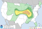
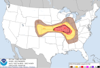
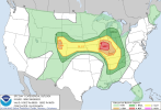
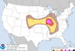
Looks like severe risk overall was upgraded to moderate, with the 5% tornado area expanded north a bit, and wind increased to 45% hatched. Hail looks about the same in the east, with an increase to 30% moderate in the west end. Also, 5% tornado risk was introduced to the WY/CO/NE area.
 

Attachments

  • Screen Shot 2023-06-29 at 1.13.25 PM.png
    Screen Shot 2023-06-29 at 1.13.25 PM.png
    932.6 KB · Views: 0
  • Screen Shot 2023-06-29 at 1.13.31 PM.png
    Screen Shot 2023-06-29 at 1.13.31 PM.png
    756.6 KB · Views: 0
  • Screen Shot 2023-06-29 at 1.13.39 PM.png
    Screen Shot 2023-06-29 at 1.13.39 PM.png
    833.3 KB · Views: 0
  • Screen Shot 2023-06-29 at 1.13.47 PM.png
    Screen Shot 2023-06-29 at 1.13.47 PM.png
    844.2 KB · Views: 0

Reed might not have to go far to chase. KGSP says:

DAY ONE...Tonight.
Isolated thunderstorms are possible this evening. Thunderstorms could
return from the northwest during the overnight hours. Cloud-to-ground
lightning strikes and briefly gusty winds will be the main threats.

.DAYS TWO THROUGH SEVEN...Saturday through Thursday.
Strong to severe thunderstorms could develop across the area on
Saturday. Thunderstorms may arrive from the northwest just about
anytime on Saturday, but the strongest thunderstorms will likely
occur during the afternoon and evening hours. Damaging winds will be
the main threat, but large hail is also possible.

Strong high pressure will create hot temperatures over the weekend.
High temperatures in the lower to middle 90s, with humid conditions
in place, will likely produce heat index values of 100 to 105 on
Saturday and Sunday afternoons, especially along and southeast of
the I-85 corridor.

Not untypical for our summers here but usually not this early with this kind of heat. I hope it doesn't become a regular pattern.
 
Back
Top